 |
A photograph showing the bridge across
Los Gatos Creek with the Los Gatos
Manufacturing Company at the end, c. 1900.
Photo by Alice Hare. [San Jose Public Library] |
When the South Pacific Coast Railroad first built its track south from San José, the track crossed to the east bank of Los Gatos Creek just in front of the Los Gatos Manufacturing Company mill. At the time, this route was intended to be the mainline for the railroad, but that would change quickly when clay was discovered along the path of the train and the entire right-of-way would have to move to the west bank of the river. Nonetheless, the route over the creek remained in place to support the mill and the clay quarry that was located at the end of the spur.
The first bridge over Los Gatos Creek was a simply-built narrow-gauge trestle with a redwood deck that sat atop piers supported by crossbeams. Like most things built by the South Pacific Coast, the deck was wide enough to support standard-gauge trains, with the expectation that the route would be upgraded at some point in the future. However, this was the only bridge over Los Gatos Creek that was never expanded. The spur was abandoned in 1907 when the narrow-gauge tracks in Los Gatos were pulled, and the bridge sat abandoned for years before the Southern Pacific Railroad finally demolished it around 1910. Nothing remains of this bridge.
 |
A popular postcard of the Los Gatos Manufacturing Company showing the wide bridge over Los Gatos Creek, 1905.
[San Jose Public Library] |
Further down the mainline, in the heart of Cats Canyon, the South Pacific Coast was forced to build yet another crossing over the creek. Unlike the bridge to the north, this one would remain a part of the mainline until the closure of the route, although it would be entirely replaced at one point.
 |
| A postcard showing the underside of the original narrow-gauge bridge prior to 1903. [CardCow.com] |
The original structure was primarily composed of a wooden double-intersecting Warren truss bridge, which was a fairly standard design that the South Pacific Coast used elsewhere along the line. Rather than passing through the truss span, the trains would run atop it over a wooden deck. The truss was built atop two wooden piers that were erected on the banks of the creek. Minor trestlework bridged the gap between the truss and the bridge abutments. Unlike the first bridge, this one was not wide enough for standard-gauge rail and certainly could not support the weight of such rolling stock. There are only a few photographs of this early bridge, including the photo above and one on file at the California State Railroad Museum.
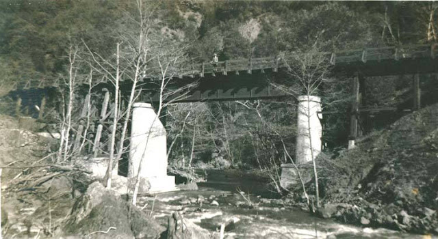 |
| Los Gatos Creek bridge #1 on a winter's day with a woman standing atop, c. 1930s. [Unknown] |
 |
An early postcard of the new bridge,
c. 1910s. [Unknown] |
The structure was replaced around 1903 with an entirely new bridge that has proven much more photogenic over the four decades it existed. The bridge consisted of a single prefabricated American Bridge Company steel plate-girder deck. This was installed atop two tall concrete piers that were anchored on either bank, roughly at the same locations as the older, wooden piers. New concrete abutments were installed and new trestlework connected the track from the abutments to the deck. Again, this was a standard design Southern Pacific adopted throughout the area in their upgrading of the old narrow-gauge tracks. Unlike the original bridge, this one did have a bit of a curve to it suggesting that the right-of-way was smoothed out a bit in the process of upgrading. The photograph at right shows a fairly wide right-of-way approaching the bridge from the south and very little brush or trees are nearby, hinting that they have recently been cleared for widening. Wooden railings were installed in the late 1920s or early 1930s, probably due to new safety laws.
 |
| A freight train passing over the bridge in 1938 during the final years of operation. [Wilbur C. Whittaker] |
Curiously, this trestle was one of the first removed by the Southern Pacific Railroad after the disastrous storms of February 1940. Bruce MacGregor and Richard Truesdale's
South Pacific Coast: A Centennial claims the photograph below was taken June 21, 1940, but that seems impossible since permission to abandon the line was not even granted until November. What is more likely is that this photograph is from June 1941, when much of the demolition work was conducted. Southern Pacific crews removed the rail, ties, trestlework, and prefabricated bridge, but they left the rest behind.
 |
| The demolition of Los Gatos Creek bridge #1, June 21, 1940/41. [Bruce MacGregor & Richard Truesdale] |
Geo-Coordinates & Access Rights:
Los Gatos Creek bridge (Manufacturing spur): 37.223˚N, 121.981˚W
Los Gatos Creek bridge #1: 37.205˚N, 121.990˚W
The bridge that once crossed over Los Gatos Creek to access the Los Gatos Manufacturing Company has long since disappeared. The construction of the State Route 17 bypass in 1956 destroyed any remnants of the trestle and the creek itself was diverted into a culvert at this location.
 |
| Northern curb of the bridge, looking south. A graffiti-covered concrete box sits atop the abutment. [Derek Whaley] |
The bridge in Cats Canyon, however, is entirely accessible from the west bank. People hiking along the Los Gatos Creek Trail will reach a point within sight of the James Lenihan Dam where the trail takes a steep climb upwards. To the left of this hill there is an overgrown path populated primarily with Scotch broom. Taking this path will bring a hiker to the northern abutment of the bridge, from which the nearest pier can be easily viewed through the trees.
 |
| Across the abutment toward the southern side one can see the piers and the clearing for the right-of-way, as well as some remnants of wood pilings. [Derek Whaley] |
From the top of the hill, both piers can be seen as well as the remnant right-of-way across the creek, which is extremely difficult to access safely. This right-of-way eventually ends in the parking lot on the northern face of the Lenihan Dam. Public access is not permitted.
 |
| A view from above the hill looking south with both piers visible as well as the right-of-way on the opposite bank. The area remains heavily overgrown and forested, and the opposite bank appears to be clear but unused. [Derek Whaley] |
Citations:
- Hamman, Rick. California Central Coast Railways. Second edition. Santa Cruz, CA: Otter B Books, 2002.
- MacGregor, Bruce, and Richard Truesdale. South Pacific Coast: A Centennial. Pruett Publishing, 1982.
- Whaley, Derek R. Santa Cruz Trains: Railroads of the Santa Cruz Mountains. Santa Cruz, CA, 2015.


No comments:
Post a Comment
Note: Only a member of this blog may post a comment.