Showing posts with label Bridges. Show all posts

Thursday, August 28, 2025

Bridges: North Coast Fills

The greatest engineering feat in Santa Cruz County’s history still survives to this day, though most people think little of it if they notice it at all. From October 1905 to June 1907, the quarrelsome Southern Pacific Railroad and Ocean Shore Railway put aside their differences to quickly and efficiently build an 11-mile-long line through the West Side of Santa Cruz to Davenport. To ensure the straightest and most level route possible, the companies approved the construction of at least thirteen trestles, which were afterwards filled with millions of cubic feet of rubble to support three standard-gauge tracks at the crest. These colossal structures remain today as testaments to the durability of early 20th century engineering and to the bold ambitions that motivated Progressive Era capitalists.

Shattuck & Desmond work crews in the process of filling the tall, slightly slumped trestle over Majors Creek, 1906. [Covello & Covello – Colorized using DeOldify]

Although the Southern Pacific’s Coast Line Railway was the first to incorporate in April 1905, it was the Ocean Shore Railway, incorporated a month later, that made the first move toward realizing its goal of connecting San Francisco and Santa Cruz via a coastal route. Grading for the Ocean Shore Railway began along the shoreline at Waddell Creek on June 1, 1905, an action that was intended to steal the march from the Coast Line Railway. The gambit forced Southern Pacific to show its cards. The company give up surveying beyond Agua Puerca Creek and it was revealed in August that Southern Pacific had acquired the exclusive contract to deliver the machinery of the Santa Cruz Portland Cement Company to the site of the planned quarry and refinery on San Vicente Creek by January 1, 1906. In addition, the railroad would become the sole rail freight carrier for the plant. But to secure these contracts, Southern Pacific needed to build a railroad to Davenport.

Thus, the race was on. Both railroads obtained most of their rights-of-way to the cement plant site by August 1905, but neither managed to secure an uninterrupted route. Instead, the rights-of-way crisscrossed each other constantly from Wilder’s Ranch to San Vicente Creek. They also crossed the county road at least six times, meaning there would be several grade crossings. None of this was appealing to the railroads or residents. In late June, T. J. Wilson of the Coast Line Railway and L. E. Rankin of the Ocean Shore Railway, both in charge of the rights-of-way of their respective railroads, met in Santa Cruz to discuss the issues with their routes. Meanwhile, Pratchner & Company began grading the Ocean Shore through the West Side of Santa Cruz.

The Wilder's Gulch fill, from "Plans of Oceanshore RR Co.," 1912.

Earlier, at the end of June, the Ocean Shore was granted permission to bridge Wilder Gulch and Sandy Flat, though it agreed not to fill these two trestles since the Wilder family wished to retain its view of and access to the Pacific Ocean. Once construction began a few weeks later, though, the railroad decided to install a fill Wilder Gulch anyway. In fact, this is the only substantial gulch on the line that did not host a trestle first. After consulting his lawyer, D. D. Wilder went to protest the fill at the company’s office in San Francisco. Despite this, the Ocean Shore continued construction, completing the fill in late November. Probably as part of a settlement with the family, the company committed to constructing a permanent trestle over Sandy Flat, as had been originally agreed.

The start of construction on the Coast Line Railway on the bluff above the Santa Cruz Union Depot yard, late 1905. [Courtesy ebay – colorized using MyHeritage]

Continued feuding and sabotage between the two railroads and unrelated problems elsewhere delayed the start of construction of the Coast Line Railway. While Southern Pacific had blocked the Ocean Shore Railway’s access to the Santa Cruz Beach for its proposed wharf, Ocean Shore in turn had blocked the Coast Line’s ability to cross through the Coast Dairies Company’s property, which was necessary for it to reach the plant site. No further progress could be made by either company and Southern Pacific would soon be forced to renege on its contract with the cement company. After several meetings, the two rivals came to an arrangement where rights-of-way would be exchanged, access at either end would be granted, the Ocean Shore would deliver the machinery for Southern Pacific as a contractor, and the two railroads would run parallel between Lombardi Gulch and the plant site, with Ocean Shore paying two-thirds of the cost since it intended to build two tracks.

The Lombardi Gulch fill, from "Plans of Oceanshore RR Co.," 1912.

The San Francisco Construction Company was hired to build the joint railroads from the Santa Cruz city limit at Moore Creek to the cement plant, as well as the Ocean Shore’s extension to Scott Creek. It subcontracted Pratchner & Chadwick to construct drainage tunnels and grade the right-of-way, while Shattuck & Desmond of Los Angeles were hired to build the trestle bridges and fill them. Hunter Bros. of Oakland were recruited to construct the Ocean Shore’s extension to Scott Creek. With speed the new priority, the plan shifted to constructing a single line of rail in order to fulfil the cement plant contract as close to the deadline as possible. It was understood that this line would afterwards become the first of the Ocean Shore Railway’s two tracks. Shattuck & Desmond also held the contract for the Coast Line Railway within the city limits, and it got to work in October to connect the line from the Santa Cruz Union Depot yard to the first meeting point of the two railroads just before the fill over Wilder Gulch, where equipment would be transferred between the two railroads once the line was completed to the plant site.

A double-headed Southern Pacific excursion train crossing the company's trestle over Sandy Gulch, ca 1947. [Courtesy Jim Vail – colorized using MyHeritage]

With all agreements made and contracts signed, construction resumed at a breakneck pace. Work began on the Ocean Shore’s 465-foot-long Sandy Flat trestle in mid-October. The wood for all the trestles came from Oregon via ships that deposited pilings and lumber on Parsons and Laguna Beaches. Steam donkeys installed atop the adjacent cliffs hauled the wood to the railroad grade, where other donkey engines moved it to the work site. This allowed bridges to be constructed quickly, though poorly since they were designed to be used only briefly. Unique among the trestles on the Ocean Shore line, the Sandy Flat trestle was designed to support a double track, since the railroad was contractually prohibited from filling the flat. Despite the design, the bridge likely never hosted a second set of rails since the Ocean Shore failed to install its second track. The Sandy Flat trestle was completed before the end of October, by which point construction crews had already shifted to a 300-foot-long trestle over Lombardi Gulch, the first joint bridge with the Coast Line Railway.

Ocean Shore Railway auditor Ted F. Wurm on right with family members standing on a trestle, presumably over Laguna Creek due to the parallel Coast Road to the right, 1906. [Marvin T. Maynard – Colorized using DeOldify]

Two joint trestles over Little Baldwin Creek and Baldwin Creek at Parson’s Beach—measuring 300 feet and 660 feet respectively—came next and were finished in mid-November. By early December, work was already nearing completion on the trestle over Majors Creek. Indeed, on December 9, the Ocean Shore’s construction train could travel nearly 7.5 miles up the coast to work on the deep cut through the Enright and Scaroni properties. Before work on the 1,100-foot-long Laguna Creek trestle was completed in late December, some bridge builders had already moved north to Yellow Bank. However, grading beyond Yellow Bank proved difficult, and the Coast Line Railway was still stuck in the West Side of Santa Cruz. This meant that neither railroad would be able to ship the first cars of machinery to the cement plant site by the first day of the new year. Fortunately for Southern Pacific and its contract, the cement company was also running behind schedule and had only sent six cars to Santa Cruz. The only realistic option was for all three parties to continue working toward their mutual goals and allow the deadline to pass.

An Ocean Shore Railway construction train atop a bridge near Davenport, 1906. [Western Railroader – Colorized using DeOldify]

In January 1906, the Santa Cruz Sentinel reported that crews were busy boring tunnels through the sandstone bluffs, a necessary step before the trestles could be filled. The Yellow Bank trestle was completed in mid-January allowing crews to move to the last two substantial trestles, over Liddell and San Vicente Creeks. Progress was slowed by heavy rains that hampered construction efforts across the line and caused the trestles at Baldwin and Laguna Creeks to settle. Both were repaired within a week and trackage was extended to the south bank of Liddell Creek by the first week of February. The Liddell trestle was completed in mid-February, even as heavy rains once more incapacitated the now-partially-filled trestles at Baldwin and Laguna Creeks. These rains also delayed completion of the San Vicente Creek trestle, though the track was extended to its southern edge by mid-March. This final trestle was completed the first week of April.

The Baldwin Creek fills at Parson's Beach, from "Plans of Oceanshore RR Co.," 1912.

As the Ocean Shore Railway was wrapping up construction of the first 11 miles of the route, the Coast Line Railway was finally making progress out of Santa Cruz. Construction of the trestle over Moore’s Creek delayed the company for at least a month, while further effort was required to widen and reinforce the fill at Wilder Gulch to allow the two lines to connect. Both the connection of the lines and the completion of the track to San Vicente were completed in the second week of April. This allowed Southern Pacific to finally haul the cement company’s machinery from a long siding on the Moore Ranch to the plant site beginning around April 15, 1906. Seventy carloads of machinery had accumulated on the siding and at the freight yard by this point. However, several factors slowed the delivery of machinery to the plant site, most notably the relatively low strength of the trestles and the fact that there were no sidings or spurs yet at the plant site. This meant that short trains of only a few cars had to continuously shuttle machinery and empty flatcars between Santa Cruz and the plant site, a tiresome and time-consuming process that further delayed construction of the plant.

The Yellow Bank fills and Coast Road realignment, from "Plans of Oceanshore RR Co.," 1912.

Simultaneously, Shattuck & Desmond’s crews shifted focus from bridge-building to bridge-filling. The Ocean Shore Railway had always planned to fill its trestles along the coast—it had little choice since it planned to run two parallel tracks with electrical equipment, which was a lot to ask from a trestle. Thus, all the trestles were relatively hastily built since they were never expected to support heavy or regular rail traffic. After its agreement with Southern Pacific, Ocean Shore expanded its plan to run three parallel tracks, with the Ocean Shore’s two tracks on the ocean side and the Coast Line’s track on the inland side. The width of the fills at the top were expected to be between 36 and 47 feet. Three to four steam shovels were eventually used to accomplish the monumental task.

The long fill over San Vicente Creek, from "Plans of Oceanshore RR Co.," 1912.

The first trestle to be filled was across Baldwin Creek, beginning in early February 1906. At Major’s Creek, an agreement was reached with the Santa Cruz County Board of Supervisors to incorporate the county road into the fill. Doing so eliminated a dangerous curve on the road and bypassed a grade crossing and short overhead railroad bridge. Similar agreements were made at Enright, where the county road was moved inland to avoid grade crossings, and at Yellow Bank, where the highway was redirected away from the fill. In late March, Shattuck & Desmond relocated its camp to Laguna Creek in order to fill the Laguna Creek and Yellow Bank trestles. Only around a third of the trestles had been filled at the time of the San Francisco Earthquake on April 18, which halted further progress for three and a half months. The Coast Line Railway had lain its rails to the south end of the Lombardi Creek trestle, but could go no further.

An Ocean Shore Railway train on a high fill hauling equipment, presumably for the cement plant, circa 1906. [Western Railroader – Colorized using DeOldify]

As work resumed in August, the Coast Line Railway was finally able to begin grading beyond the Wilder property. Its first task was to widen cuts to make space for a second set of rails. This required heavy use of dynamite in some places, which spread debris across the right-of-way and forced the suspension of all passenger and some freight service on the Ocean Shore line. The blasted rubble was transferred to waiting ballast cars, which took the aggregate to the nearest trestle to serve as fill. Making cuts, transferring rubble, importing additional aggregate from nearby quarries and the ruins of San Francisco, and dumping them to create towering fills took a lot of time and energy, leading to further delays. The largest fill across San Vicente Creek just south of the cement plant was 1,400 feet long and was estimated to contain approximately 1,250,000 cubic feet of material, primarily rock and shale.

An Ocean Shore construction train dumping rocks below the bridge over San Vicente Creek, circa May 1907. [Uncertain provenance – Colorized using DeOldify]

The Coast Line resumed laying rails in November 1906 and installed them whenever a fill or cut was ready, leading to piecemeal sections of track across the line that were gradually connected together. The completion of the San Vicente Creek fill in mid-June 1907, followed shortly afterwards by the installation of the Coast Line rails across it, marked the successful end to the joint construction project between the Ocean Shore Railway and Southern Pacific Railroad. Shattuck & Desmond, working for the Ocean Shore Railway on its longer route, constructed several additional fills to the north across Agua Puerca and Molino Creeks and smaller gulches in May and June 1907 before concluding the Ocean Shore’s first phase of construction in Santa Cruz County.

The single surviving Southern Pacific Railroad tracks crossing the San Vicente Creek fill, with the adjacent Ocean Shore line a sandy pathway beside it, circa 1930. Davenport Wharf and a warehouse can be seen in the distance. [Courtesy WorthPoint – colorized using MyHeritage]

The legacy of the joint Ocean Shore–Coast Line construction project to Davenport and beyond is still felt in many places along the North Coast today. For decades, the Southern Pacific Railroad’s wooden trestle over Sandy Flat, built independently sometime in 1906, welcomed picknickers, trainspotters, and photographers before it was finally filled, probably in the 1960s or 1970s. The joint fill at Majors Creek is now shared by Highway 1, while three short Ocean Shore fills north of Davenport have been repurposed for the highway.

The San Vicente Creek drainage tunnel below the former joint Ocean Shore–Coast Line Railway trackage, June 16, 2007, by Jef Poskanzer. [Courtesy Wikimedia Commons]

Beneath every single fill, the original tunnels still drain creeks and lagoons, rarely requiring maintenance despite being over a century old. Though mostly out of use since the closure of the cement plant in 2010, the Southern Pacific Railroad’s former right-of-way, now owned by the Santa Cruz County Regional Transportation Commission, officially remains an active line with tentative plans for reactivation in the near future. Much of the adjacent Ocean Shore Railway right-of-way remains intact and is used by local farmers as a makeshift road, though parts will be repurposed for the planned Monterey Bay Sanctuary Scenic Trail Network.

Citations & Credits:

  • Ocean Shore Railroad, "Plans of Oceanshore RR Co.," 1912, based on survey circa 1906.
  • Southern Pacific Railroad, maps and plans, California State Archives.
  • Various newspaper articles from the Santa Cruz Morning, Evening, and Weekly Sentinel; The Pajaronian; and the Santa Cruz Surf.

Friday, August 23, 2024

Bridges: Live Oak Area

The Santa Cruz Railroad had a goal—indeed a requirement—if it wanted to earn its first subsidy payment in 1874: it had to build 5 miles of operable railroad beginning in Santa Cruz and heading east. But this task would not be easy. The narrow-gauge right-of-way would have to cross the San Lorenzo River, Woods' Lagoon, the top of Schwan Lagoon, and Rodeo Gulch before it reached the 5 mile mark near the west bank of Soquel Creek. The largest engineering obstacle was obviously the river, while a long trestle was required to cross Woods' Lagoon. But four smaller trestles were still required before the railroad could achieve its initial goal.

The northern end of Schwan Lagoon with Loma Prieta in the distance, circa 1920. [University of California, Santa Cruz – colorized using MyHeritage]

Schwan Lagoon is today known as the eastern lake of Twin Lakes, though when the area was initially settled, it was a true lagoon, with brackish water flowing into the Monterey Bay. By the 1870s, the lagoon was mostly cut-off from the bay and its salinity had dropped substantially, though there was still a small outlet and the lake was sometimes inundated during king tides and winter storms. The west side of the lagoon had been owned by the family of Manuel Rodriguez since before California became a state, and his descendants would continue to own property there well into the twentieth century. The east bank, meanwhile, was owned by Jacob Schwan, a German immigrant whose name became associated with the lagoon. At the head of the lagoon, Leona Creek flows from the mountains through Arana Gulch and provides the lagoon with its most substantial source of freshwater. Two other unnamed feeders drain from to the east from nearby fields that were once scattered forests atop a coastal sandstone terrace. Between the creek and these feeders was the land of Henry B. Doane. It was over these creeks that the Santa Cruz Railroad had to cross in order to continue east toward Soquel Creek and Camp Capitola

Survey Map of East Santa Cruz showing property owners, circa 1870. Drafted by Thomas W. Wright, Santa Cruz County Surveyor. [Santa Cruz GIS]

After crossing Woods' Lagoon, passing through a narrow cut, and ascending to the top of the terrace, the Santa Cruz Railroad right-of-way reached Leona Creek. The original bridge over this year-round stream would have measured around 200 feet and was probably a trestle-type bridge, though no photographs have been found of the original structure. About 450 to the east, a bridge about 110 feet long crossed an unnamed seasonal feeder creek. Like the bridge before, this was likely of a simple trestle design. Continuing another 1,300 feet to the east, a short bridge probably around 70 feet long crossed the easternmost unnamed seasonal feeder creek of Schwan Lagoon. Again, this was likely a trestle style and would not have been very high above the ground.

The Southern Pacific Railroad's right-of-way through the East Side, circa 1890. [Santa Cruz GIS]

All three of these bridges suffered the same fate, though probably not at the same time. When the Southern Pacific Railroad took over the Santa Cruz Railroad and standard-gauged the tracks in 1883, the Leona Creek bridge was probably filled, with a wide culvert built at its center to allow the waters of the creek to pass under the right-of-way. The other two bridges may have just been widened initially since they were not very high above the ground.

Southern Pacific Railroad tracks through the Twin Lakes area, circa 1953. [UC Santa Cruz – colorized using MyHeritage]

Aerial photographs show that both of the eastern bridges had been filled by 1928, but the ground around them, especially the easternmost bridge, was still relatively clear of debris, suggesting the filling had occurred fairly recently, perhaps in the 1910s, when much of the local railroad infrastructure was improved. Culverts would have been built beneath both of these fills, too. However, in the mid-1950s, the site of today's Simpkins Family Swim Center and Shoreline Middle School was turned into an aggregate yard. In the process of creating this yard, the area was leveled and the seasonal creek bed was buried. This included any trace of the fill and culvert.

Lithograph of the residence of James Corcoran, circa 1880. [UC Santa Cruz]

To the east of Schwan Lagoon, another substantial lagoon had its origins in the Santa Cruz Mountains and Rodeo Gulch, through which its only significant freshwater source flowed. The west bank of this lagoon had been settled in the mid-1850s by James Corcoran, an Irish immigrant, who owned the property through which the Santa Cruz Railroad was built in 1874. He would eventually subdivide and the tracks would form his northern boundary with Philip Legett and Martin Kingsley. East of Rodeo Gulch, the right-of-way passed through the land of V. W. Thompson. The railroad faced no substantial obstacles across this 0.6-mile-long stretch that would become known as Del Mar or Cliffside in later years. But Rodeo Gulch itself required the most substantial bridge in the Live Oak area.

U.S. Forestry Service aerial survey showing Southern Pacific Railroad trackage through Live Oak, 1948. [UC Santa Cruz]

The bridge over Rodeo Gulch was the third most substantial structure between Santa Cruz and Soquel Creek, measuring about 300 feet long, but it probably still only required a trestle bridge due to the low flow of the creek through Rodeo Gulch. As with the bridges above, no photograph seems to exist of the original bridge over Rodeo Gulch nor does the Santa Cruz Sentinel report on the type of structure erected here. Like the other three bridges, the structure across Rodeo Gulch was either replaced or modified when the Southern Pacific Railroad standard-gauged the track in 1883. At the same time, it was shortened a little, with fill replacing some of the trestlework at either end. This second or modified bridge was replaced again, possibly as late as the 1920s, by a concrete viaduct-style bridge with regularly spaced support piers and a ballast deck. The fills on either side may have been extended further when this was installed.

The current railroad bridge over Rodeo Gulch, December 2018. Photo by Derek Whaley.

Of the original four Live Oak railroad bridges, only the Rodeo Gulch bridge survives. Two of the those at the head of Schwan Lagoon are now fills with culverts running beneath them, while the third has been completely buried and sits unnoticed beside the Simpkins Family Swim Center. Frustratingly for railroad explorers, this non-existent fill is the only one that is easily accessible without trespassing on the Santa Cruz Branch Rail Line. It sits directly adjacent to the turnaround at Shoreline Middle School. However, the smaller surviving fill can be viewed and accessed from the end of Live Oak Avenue. The fill over Leona Creek and the bridge over Rodeo Gulch are inaccessible to the public. All four of these sites are owned by the Santa Cruz County Regional Transportation Commission and are scheduled to be included as part of the county's coastal rail and trail project.

Citations & Credits:

  • Donald T. Clark, Santa Cruz County Place Names: A Geographical Dictionary, second edition (Scotts Valley, CA: Kestrel Press, 2008).
  • Bruce MacGregor, The Birth of California Narrow-Gauge: A Regional Study of the Technology of Thomas and Martin Carter (Stanford: University Press, 2003).

Thursday, December 1, 2022

Bridges: Woods Lagoon

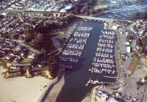
The area known as Twin Lakes referred to a section of unincorporated Santa Cruz County land between Woods Lake and Schwan Lake, both actually lagoons formed at the outlets of Arana and Leona Creeks respectively. While Schwan Lagoon retains much of its wetland charms, Woods Lagoon endured a substantial transformation in the 1960s when it became host to the Santa Cruz Small Craft Harbor. Yet long before this event occurred, the lagoon suffered its first major human terraforming effort, when the Chinese workers of the Santa Cruz Railroad installed a bridge across its midsection in 1875.

Southern Pacific #2764 running a Sun Tan Special across the Woods Lagoon bridge, July 28, 1940. Photo by Wilbur C. Whittaker. [Jim Vail – colorized using MyHeritage]

Woods Lagoon was named after John Woods and Mary Ann Silvey of Georgetown, Ohio. The Woods family moved to California during the Gold Rush but soon gave up and moved to Santa Cruz County. In 1849, John worked at the Bennett mill on Love Creek (today's Ben Lomond). Soon, though, he applied for recognition of a tract of land that he had acquired on the west bank of Arana Creek, which was registered to he and his wife on November 14, 1849.

Woods Lagoon, ca 1895. [Santa Cruz Public Libraries – colorized using MyHeritage]

Over subsequent years, the lagoon became a popular picnic and swimming spot, and it also later became well known to duck hunters. When the Santa Cruz Railroad's surveyors arrived in 1874, the Woods sold them a right-of-way through their property. The completion of the railroad two years later led the Woods to sell substantial acres of their property to interested parties, though the family kept a large section for themselves until after John's death on October 11, 1887. One such party was Samuel Hall, who founded Lake Marina in 1880, in the process briefly renaming Woods Lagoon. His resort failed after only one season, though. Shortly before John Woods' passing, Foster N. Mott founded Camp Seabright in 1884 on a small twelve-acre tract beside the lagoon. As a result, Woods Lagoon was sometimes called Seabright Lake in promotional material.

Early Southern Pacific diamond stack locomotive hauling a strange mixed train over the Woods Lagoon bridge, ca 1888. [University of California, Santa Cruz, Digital Collections – colorized using MyHeritage]

Woods Lagoon proved to be a mostly insubstantial impediment to the railroad's Chinese construction crews. The western approach to the bridge required a shallow cut that John Woods and his son dug by themselves. Beyond that, the bridge crossed Woods Lagoon at the narrowest point. Although no photographs survive of the original narrow-gauge bridge, it is likely that the later standard-gauge bridge, enlarged by the Southern Pacific Railroad in 1883, was in fact just an upgrade to the original structure. The photographs that survive show an austere open deck trestle viaduct with sixteen redwood piling piers, all standing almost perfectly upright, and wood abutments at either end. Some of the fill material pulled out of the shallow cuts on either approach to the bridge may have been dumped at the ends of the bridge to  reinforce the abutments.

Excursion train passing over the Woods Lagoon bridge, July 7, 1950. Photo by Wilbur C. Whittaker. [Jim Vail – colorized using MyHeritage]

This structure remained across the lagoon until Spring 1911, when it was replaced with a sturdier, more modern design. The new structure was composed of eighteen redwood piling piers, all tilted inward to provide additional support. These supported a redwood girder closed ballast deck with concrete abutments on either end. The abutments were likely installed to help reinforce the fills behind them. This also resulted in a slightly shorter span across the lagoon, with the bridge measuring around 282 feet. Most historical photographs of the lagoon date to this period.

Southern Pacific survey map showing a proposed pedestrian sidewalk on the north side of the Woods Lagoon bridge, 1946. [Vasona Branch]

After over fifty years of relative peace and quiet on Woods Lagoon, things changed rapidly. In 1964, the U.S. Army Corps of Engineers dredged out the section of Woods Lagoon between the lagoon mouth and the railroad bridge in order to create the Santa Cruz Small Craft Harbor. Until this time, Santa Cruz did not have a proper harbor protected from the elements, and commercial use of the Santa Cruz Municipal Wharf, built in 1914, had declined to almost nothing. With the new harbor, residents would be able to safely protect their yachts, sailboats, and motorboats from the elements. In the process of creating the harbor, East Cliff Drive was bisected. To correct for this, a new vehicular bridge was extended from the end of Murray Street, which had previously ended at Seabright Avenue, to Eaton Street.

Santa Cruz Small Craft Harbor with the Glen E. Coolidge Memorial Bridge and railroad bridge at upper-center, 1973. [Santa Cruz Public Libraries]

Plans to replace the railroad bridge began in July 1968. The trestle viaduct blocked access to Woods Lagoon beyond the railroad grade. Plans for a new bridge were finalized in December 1969 and work began the next year. To maintain continuous rail service, the railroad bridge was built between the viaduct and the Murray Street bridge. Rather than a trestle, which would not allow boats to pass under it, the new design called for a concrete girder closed ballast deck bridge suspended above the lagoon via six concrete piers and two concrete abutments. The bridge reached a height of 31.88 feet above the mean tide line. To achieve this extra height, the bridge had to begin further back along the railroad grade, extending the final length of the bridge to 425 feet. Once the new bridge was completed, the old viaduct was completely dismantled. The expansion of the upper harbor began in 1972 and was completed the following year, adding 560 more berths for boats.

The bridge over the Santa Cruz Small Craft Harbor, 2017. [Derek Whaley]

The 1971 railroad bridge remains in place today and is one of the more recent bridges along the Santa Cruz Branch Rail Line. However, due to the closure of parts of the line further to the east, the bridge is only currently used for maintenance-of-way vehicles.

Geo-Coordinates & Access Rights:
Western abutment: 36.9681, -122.0036
Eastern abutment: 36.9681, -122.0022

The Woods Lagoon bridge is one of the easiest railroad bridges to view since it runs directly to the north of the Glen E. Coolidge Memorial (Murray Street) Bridge over the Santa Cruz Small Craft Harbor. It can also be viewed from below by parking at the northern end of the Mariner Park Way parking lot off Atlantic Avenue and taking the road under the bridge alongside the harbor. Another road beneath the railroad bridge is accessible off Murray Street on the east side of the harbor. As with the entire Santa Cruz Branch Rail Line, the railroad right-of-way is owned by the Santa Cruz County Regional Transportation Commission and any walking along the tracks without permission is trespassing.

Citations & Credits:

  • Clark, Donald. Santa Cruz County Place Names: A Geographical Dictionary, second edition. Santa Cruz, CA: Otter B Books, 2002.
  • Santa Cruz County GIS maps.
  • Santa Cruz Sentinel. Various articles 1874–1973.

Thursday, December 24, 2020

Bridges: San Lorenzo River Mouth

On the eastern edge of the Santa Cruz Main Beach, the San Lorenzo River meanders gently, pulsing with the tides as it exits into the Monterey Bay. After the Santa Cruz Railroad incorporated in June 1873, the river would prove to be one of its greatest obstacles. Most of the problem was funding, but the geographic terrain at the river's mouth was always going to be an issue. A large sandbar ends the beach, jutting in between the bending river and the relentless sea. The beach was smaller then and the river was wider and deeper. At the time, there were no developments at the eastern end of the beach, with only grass and ice plants keeping the sand from washing away with the tide. The task of conquering this tenuous terrain was difficult but not impossible, but it was a constant struggle between human ingenuity and the tireless power of nature.

A Southern Pacific freight train steaming across the second bridge over the San Lorenzo River at the Santa Cruz Main Beach towards the Boardwalk, August 1946. Photograph by Ed Webber. [Fred Stoes – colorized using DeOldify]

The first railroad bridge over the river required a monumental feat of construction and funding to accomplish since it was erected by the ever cash-strapped Santa Cruz Railroad. Begun in November 1874, it was completed on April 17, 1875. Once done, the bridge was approximately 600 feet in length, with around 350 feet comprised of a trestle viaduct and the remainder an elevated, wooden double-intersecting Warren truss span through which trains could pass. The span was anchored on the eastern side by an abutment installed on the cliff, while the western side sat atop a large wooden pier. Like the other bridges along the line, the San Lorenzo River bridge was painted white using a lime and oil blend in hopes of protecting it from rot and fire.

The first bridge over the San Lorenzo River at the Santa Cruz Beach, ca 1890. [University of California, Santa Cruz, Legacy Digital Collections – colorized using DeOldify]

For two years, the bridge served its purpose while the railroad route was completed and regular service began. But the poorly-built structure was destined to fail, especially during the harsh Santa Cruz winters when powerful waves lashed the coast. The first such failure happened in late 1877, when part of the trestlework collapsed. Railroad investors were asked to hand over their profits from the previous year to fund repairs. They did so begrudgingly and the bridge was repaired. In late 1878, to protect the bridge's single pier from being undercut, wooden cladding was attached to all sides of it and the pier was weighted down with heavy rocks to give it more weight.

The first bridge viewed from the north showing severe damage following a winter storm in January 1881. [UCSC Legacy Digital Collections – colorized using DeOldify]

Winter storms struck again on January 27, 1881, and over fifty feet of the viaduct collapsed. The Santa Cruz Weekly Courier on May 4, 1881, explained: "The violence of the elements last winter was more than a match for his [Frederick A. Hihn's] patient investments, and when the bridge across the San Lorenzo went out to sea, it was the death knell of the Santa Cruz Railroad." The damaged pieces were not actually washed out, but rather were collected and taken to a warehouse awaiting reassembly. However, Hihn, the chief promotor of the railroad, was unable to convince investors to pay for the repairs. It marked the end for the Santa Cruz Railroad, which struggled to compete with the recently-opened South Pacific Coast Railroad.

The first bridge viewed from the south following the storm of January 27, 1881. [UCSC Legacy Digital Collections – colorized using DeOldify]

In May 1881, the Southern Pacific Railroad bought a controlling interest in the Santa Cruz Railroad and set to work repairing the line. The bridge was quickly restored and reopened on June 4, 1881. Over the next two years, the structure was reinforced and repaired repeatedly, and it was eventually expanded and heavily reinforced to allow it to carry standard-gauge trains. The core structure of the bridge—the truss span over the river—appears to have survived all of these storms and crises unscathed, so the real trouble was the viaduct, which was more exposed. Initially, the railroad seems to have simply driven additional piles into the sand. This allowed the upgraded standard-gauge bridge to reopen on November 15, 1883 along with the rest of the route.

People posing at the beach along the river with the first bridge and the vehicular bridge over East Cliff Drive visible in the background, ca 1895. [UCSC Legacy Digital Collections – colorized using DeOldify]

Over time, Southern Pacific replaced all of the piles with heavy-duty redwood logs and installed stronger bents to keep them stable. At some point in the 1890s, the railroad also belatedly added claddings to the entire truss span, turning it into a covered bridge.

The first bridge with the truss span covered in wood cladding, ca 1900. [UCSC Legacy Digital Collections – colorized using DeOldify]

As activity at the beach warmed up, interest in a new bridge arose. In February 1904, Fred Swanton, promotor of what would become the Santa Cruz Beach Boardwalk and a major investor in the Santa Cruz, Capitola & Watsonville streetcar line, hoped to complete the extension of his line to Capitola and beyond. He viewed a route across the river mouth as the best option and began negotiations with the city and Southern Pacific to install a parallel track beside the existing railroad bridge. In addition, he hoped to have a pedestrian bridge installed to provide easy pedestrian access to Seabright from the Main Beach.

The first bridge over the San Lorenzo River viewed from the south, with the truss in wood cladding, ca 1900. [UCSC Legacy Digital Collections – colorized using DeOldify]

Although the streetcar bridge was never built, Southern Pacific apparently took the initiative and began upgrading the former Santa Cruz Railroad bridge. On May 5, the Sentinel reported that a train was dumping gravel on either side of the viaduct at the beach to turn it into a fill. On May 15, news broke that the railroad intended to replace the old wooden truss with a modern steel bridge. Similar projects were announced across the county. Speculators hoped that Santa Cruz would become the main route of the Coast Division for San Francisco—Los Angeles traffic once the route through the mountains was standard-gauged and the Mayfield Cut-off was completed. Nothing so grand would come, but the new bridge would be built.

Earliest known photograph of the second bridge over the San Lorenzo River at the Santa Cruz beach, with not structures in the immediate vicinity and a pedestrian walkway beside the bridge, ca 1906. [UCSC Legacy Digital Collcetions – colorized using DeOldify]

The actual construction was a prolonged affair since neither local businesses nor Southern Pacific wished to negatively impact summer traffic to the beach. While the fill work was completed before the start of the summer season, most of the supplies for the new bridge only came in the Autumn. Loads of cement for the piers and abutments arrived on October 4 and it took over three months for the piers to be completed. The job was still not done by May, when the Sentinel reported that construction continued with trains using the older wooden bridge in the meantime. This is the only mention of both bridges coexisting during this period, and it means that their alignments were not identical. Even as construction was wrapping up, Seabright residents came to an agreement with Southern Pacific to install a permanent steel foot-bridge beside the new bridge.

Boaters beneath the second bridge over the San Lorenzo River with the L. A. Thompson Scenic Railway in the distance and some structures at right, ca 1915. [UCSC Legacy Digital Collections]

The structure, which was completed around mid-July 20, 1905, was approximately 305 feet in length, with the remainder of the old bridge completely buried in fill. Approximately 65 feet of the new bridge was a prefabricated steel plate girder open deck span that was anchored on one side by a concrete abutment and the other by a concrete pier. The pier also served as the western foundation for a 120-foot-long prefabricated Warren truss span with verticals. This was anchored to another concrete pier after which an identical truss connected to the eastern cliffside via a concrete abutment. The two truss bridges were open deck bridges through which trains could pass, as with the previous bridge. Southern Pacific officially designated the bridge #119.67 (based on the mile marker) on the Santa Cruz Branch.

A Southern Pacific excursion train heading to Watsonville over the second bridge over the San Lorenzo River. Below the bridge, the tracks for the miniature Sun Tan Jr. Railway head to the Shoot-the-Chutes at River Park, ca 1930. [UCSC Legacy Digital Collections – colorized using DeOldify]

Since it was built, the bridge has become a popular object for photography, with photos of the bridge spanning its entire history. Indeed, the very history of the lower end of the Boardwalk and the river mouth can be followed partially through photographs of this bridge. Most famously, the bridge featured in the 1987 film The Lost Boys, although it has appeared in other less well-known films and has become an iconic feature on the Santa Cruz waterfront. Every summer, thousands of people use the bridge and its adjacent pedestrian walkway to walk to and from the Boardwalk and Seabright.

The lower end of the Boardwalk in the 1930s with beachgoers lounging beside the San Lorenzo River and the second bridge in the distance. [UCSC Legacy Digital Collections – colorized using DeOldify]

Today, the second bridge across the river remains intact, but in a decreasing state of repair. A report delivered on August 31, 2012 commissioned by the Santa Cruz County Regional Transportation Commission, which owns the bridge, noted the bridge to be in poor condition with potentially high rehabilitation costs. That being said, it also noted that the bridge was in surprisingly good condition for its age and is cheaper to repair than to replace. The primary concern relates to long-term damage from two earthquakes. Built in 1905, the bridge sustained minor damage in both the 1906 San Francisco Earthquake and the 1989 Loma Prieta Earthquake. These two events caused the bridge to shift northward slightly in relation to its piers and anchors, although thus far these have not negatively impacted its stability. Ultimately, the bridge will need to be replaced in no more than 25 years even if repaired.

A Southern Pacific passenger train crossing the second bridge over the San Lorenzo River at the beach with beachgoers watching from below, ca 1920. [UCSC Legacy Digital Collections – colorized using DeOldify]

Until that time, the railroad bridge over the mouth of the San Lorenzo River remains a legacy of the Southern Pacific at its height and the Santa Cruz Main Beach right at the moment that it evolved from a scattering of bath houses into a full amusement park. The bridge is old and deteriorating, but represents an earlier age of rail and tourism. And to the many people who cross it legally on the adjacent footpath or illegally by hopping the crossties, it represents a core component of the Santa Cruz waterfront.

Citations & Credits:
  • Hamman, Rick. California Central Coast Railways. Second edition. Santa Cruz, CA: Otter B Books, 2002.
  • MacGregor, Bruce. South Pacific Coast: A Centennial. Boulder, CO: Pruett Publishing, 1980.
  • Santa Cruz Sentinel, 1904-1905.
  • Whaley, Derek R. Santa Cruz Trains: Railroads of the Santa Cruz Coast. Santa Cruz, CA: Zayante Publishing, forthcoming.

Friday, January 10, 2020

Bridges: Gharky's Vineyard

The grade between Mission Hill in Santa Cruz and the Hogsback within Henry Cowell Redwoods State Park is relatively steep for a railroad. Designed as it was in 1875 to access the Davis & Cowell property in Rancho Rincon—a requirement if the railroad wished to build through the property—meant that certain benefits of the earlier route surveyed by the San Lorenzo Valley Railroad in the late 1860s had to be sacrificed. Numerous solutions, too, had to be adopted, such as a tunnel through the Hogsback and substantial bridgework along the slide-prone Coon Gulch. One lesser known, but vitally important, section of track, though also had important bridgeworks installed.

Birds' Eye View of the City of Santa Cruz, 1907. Gharky's Vineyard is at the center-top of this painting, although at this time it is mostly just undeveloped land with an indistinguishable fill for the railroad right-of-way (an unseen train on the tracks is billowing smoke). Downtown Santa Cruz is from the center down and the San Lorenzo River is at right.
[Bancroft Library]
Along the northern boundary of the Santa Cruz city limits, David Gharky owned an 18.893 acre plot that ran beside the west side of (West) San Lorenzo River Road (State Route 9). The awkwardly-shaped property contained a small stream that watered private vineyards owned by Gharky. Unlike the route to the north, through which all gulches and gullies were culverted, Pogonip Creek through Gharky's Vineyard supported a small floodplain that made the grade into the forest all the steeper. To rectify this issue, the Santa Cruz & Felton Railroad constructed a substantial fill between today's Encinal Street and the northern boundary of Gharky's property, through his lands and those of J. Heller, with an 80-foot bridge across the creek itself, which passes under the right-of-way between modern Golf Club Drive and Encinal Street. The grade remained relatively steep since the fill was not heavily reinforced and, therefore, settled more than was desirable. Nonetheless, this worked for the light-weight rolling stock of the narrow-gauge Santa Cruz & Felton during the four years that it ran as an independent railroad.

Survey map of the City of Santa Cruz showing the location of David Gharky's land at the northern city limits, 1866. Map by Thomas W. Wright, Santa Cruz County Surveyor. [Jason Christian]
In 1879, the Santa Cruz & Felton was taken over by the South Pacific Coast Railroad, which ran heavier rolling stock and longer, heavier trains, despite remaining narrow-gauge. One of the company's many improvements along the Santa Cruz & Felton line was properly reinforcing the fill through Gharky's vineyard. In August, Chinese work crews moved in and completely regraded and refilled the stretch of track and removed the bridge, replacing it with a culvert and diverting the creek through a canal. It is probably around this time that the pond on the east side of the tracks along Pogonip Creek first formed. It remains today as the Salz Pond, although it is relatively inaccessible to the public. For three decades, nothing changed except the fill's widening around 1907 to support standard-gauge rails. At this time, the culvert was broadened slightly to an approximately five-foot-long ballast-deck bridge that runs over Pogonip Creek.

The creation of the Casa del Rey Golf Links at Pogonip in 1912 prompted the need for an access road. Rather than purchasing several easements from neighbors further south, Fred Swanton purchased only two: one through Gharky's old vineyard, and the other that continued through the adjacent lands once owned by Thomas W. Hinds. This new route met the railroad grade at a point where the tracks were high above the surrounding land, so a cut was made through the fill, and a new bridge installed atop the road.

The bridge over Golf Club Drive on a rainy day, c. 2012. [Derek R. Whaley]
The new bridge above Pogonip Avenue (later Golf Links Boulevard and now Golf Club Drive) was only 20 feet in length and involved no trestlework at all. Instead, a wood ballast bridge was installed over the road supported by two redwood piers, which were eventually shielded from damage with lumber coverings. This unassuming structure has remained in place for over one hundred years, in a sense marking the gateway to Pogonip to visitors of the park. The bridge remains in use by the Santa Cruz Big Trees & Pacific Railway and is now owned and maintained by Roaring Camp Railroads.

Geo-Coordinates & Access Rights:
Northern (Western) abutment: 36.9897N, 122.0335W
Southern (Eastern) abutment: 36.9895N, 122.0334W

The bridge remains quite visible and accessible to the public along Golf Club Drive. Visitors, however, are advised that the tracks atop the bridge remain an active railway and the area is also heavily frequented by the homeless, so caution is advised at all times. Furthermore, crossing the bridge or walking the tracks is considered trespassing without receiving permission from Roaring Camp Railroads.

Citations & Credits:

Friday, December 20, 2019

Bridges: Shady Gulch

Perhaps the most unchanged and best known feature of the railroad route between Santa Cruz and Felton is the long trestle bridge over Shady Gulch. Erected by the narrow-gauge Santa Cruz & Felton Railroad in early 1875, the bridge originally spanned both a natural, steep gully and the Eben Bennett toll road. From its top, passengers, crews, and brave trackwalkers could look down upon the California Powder Works, which sat at the bottom of the valley along the San Lorenzo River. Excursion trains would sometimes stop on the bridge to allow sightseers to enjoy the view for a moment.

The Shady Gulch bridge during the South Pacific Coast Railroad years, 1884. Photo by Taber. [Bancroft Library]
The original bridge was 262 feet long and thirty-eight feet high at its tallest point. The entire structure was originally composed of locally-sources coast redwood, formed into a rather standard trestle design. In the center of the bridge, five piers of varying lengths reached down to the bottom of the gulch via tall redwood posts, reinforced with bents and crossbeams. Atop the two sections of road, longer spans were erected, reinforced with multiple bents. The bridge had no walkway or railing along the top, but signs at either and and at the midway point did warn people of the dangers of crossing the bridge. This section of track also has a steep grade from the Potrero District north of Santa Cruz to Rincon, so the bridge itself has about a two percent incline from its south abutment to its north.

A Suntan Special crossing the Shady Gulch bridge, c. 1930s. Photograph by Fred Stoes. [Jim Vail]
When the Southern Pacific Railroad finally upgraded the route to standard-gauge in the second half of the 1900s, this bridge finally was replaced with a slightly more modern structure, albeit one that looks shockingly similar to its predecessor. The center portion remained a trestle design, with tall posts reaching the bottom of the gulch and more intricate bents and crossbeams supporting the posts. On either side of the bridge, more heavy-duty redwood piers were erected to support short, open-deck plate girder sections that sat over both road underpasses. At a later point, a support pier consisting of two steel girders and a girder bent were installed under each open deck to provide further support. By this point, second-growth redwood trees had mostly obscured the Powder Works, which would close a few years later anyway, and there is little view of anything outside the immediate area of the bridge today.

Streetview photograph of the Shady Gulch bridges, 2012. [Google]
For another twenty-five years, the narrow county road continued to run under the bridge, but increased traffic and the need for two lanes finally forced the local government to erect a bypass bridge. In 1930, the county road was rerouted across Shady Gulch via a new concrete bridge built beside the railroad bridge. The old road remains intact, albeit poorly maintained with its concrete surface long broken and buried under ninety years of forest debris.

Geo-Coordinates & Access Rights:
Northern (Western) abutment: 37.0071N, 122.0447W
Southern (Eastern) abutment: 37.0067N, 122.0440W

Today, the Shady Gulch bridge is one of the most recognizable railroad structures in the county, visible to everybody who drives State Route 9 between Santa Cruz and Felton. It is still used seasonally by the Santa Cruz Big Trees & Pacific Railway. The bridge is considered a part of an operational railway and crossing it is absolutely forbidden for reasons of trespassing and safety. People wishing to take photographs of the bridge can pull off (carefully) at either part of the abandoned county road that passes under the bridge. The former road also acts as an access trail for the Pogonip-UC Santa Cruz trail network.

Citations & Credits: