Showing posts with label sources. Show all posts

Thursday, October 24, 2024

Sources: Family History

The family history and genealogy industry is booming, with people now able to even analyse the DNA of their pets. In the United States and other former colonies with large populations descended from Europeans, the idea of tracing one's ancestors back to their immigrant ancestors and beyond is appealing. It helps people establish and build upon cultural connections to other countries and peoples. Researching genealogy and ancestry has its dark side, too, but most people search for their ancestors out of curiosity or to discover long-lost relatives. Because family history is often considered a topic for amateurs or retirees, it is sometimes disregarded as an important part of local history research. But that could not be farther from the truth!

Members of the Leibbrandt Family, circa 1900. [Courtesy UC Santa Cruz – colorized using MyHeritage]

One thing that every local historian learns early on is that every town has its founding families. Depending what one may be researching, these families may be important to identify early on. When a community is first established, there is usually only a small number of individuals living there. This means that intermarriage between these families is common and frequent. Indeed, it is more unusual to find a founding family that doesn't have genealogical connections to other members of the community, and when this does occur, it is usually because of religious or cultural reasons. Even areas of research that seem too niche or obscure may have unexpected genealogical ties to the wider community that are worth noting.

Genealogy of the family of José Joaquín Castro of Rancho San Andrés, an early Spanish settler whose family married into several other prominent Californio and American families. From Ronald G. Powell, The Tragedy of Martina Castro: Part One of the History of Rancho Soquel Augmentation (Zayante Publishing, 2020).

For Santa Cruz County, there are several early families whose importance to the area's history resonates to this day. Descendants of these families still live in the county, own businesses, run for politics, and lead community groups. Perhaps the most influential family has been the McPhersons, whose progenitor, Duncan McPherson, became co-owner of the Santa Cruz Sentinel in 1864. His descendants continued to run the newspaper until 1990. Meanwhile, a great grandson, Bruce A. McPherson, has served in the California State Assembly and Senate, as well as Secretary of State, and currently sits on the County Board of Supervisors. Members of the family, like most 19th century Santa Cruz families, married into several other prominent families, notably the Hinds and Miller families.

Members of the Bennett family, ca 1905. [UC Santa Cruz – colorized using MyHeritage]

Ways of using this type of source:

Researching genealogy is unique in that one searches for specific people, sometimes outside of an obvious context. To begin any family search, one must have at minimum a name (first and last) and a date. It can be a birth or death date, a marriage date, a burial date. The options are quite broad and don't have to be exact. From a name and a date, the entire world can open up. Alternatively, nothing may happen at all. A frustrating truism for any family history researcher is that the people who are best recorded are the famous and the infamous—if a person was just normal, as most people are, it may be difficult to find a lot of information on somebody.

An unnamed family, possibly in the Soquel or Live Oak area, posing in front of their home, circa 1890. [UC Santa Cruz – colorized using MyHeritage]

If you have a name, approximate date, and a location, then a good place to start a genealogical search is FindAGrave.com. This database compiles millions of headstones and cemetery records into one place, often with photographs of the headstones, newspaper clippings, and even photos of the deceased. It is ideal for people buried in the United States, United Kingdom, or other English-speaking countries, though it is gradually expanding beyond the Anglophone world. An account is not required, though if you create one, you can save your research. The benefit of starting with FindAGrave is that you can often fill in several blanks all at once, which can provide you with information to dig deeper. As with all genealogical websites, FindAGrave is not perfect and prone to errors, but the photographs, clippings, and gravesite details all help verify the information.

Frederick Duncan McPherson Sr.'s FindAGrave page.

Using the example of Frederick Duncan McPherson Sr.'s record, you can find a date of birth, place of birth, date of death, place of death, burial location, plot number, and several genealogical connections linked together by users based on headstone details and newspaper clippings. With this information in hand, other websites become more useful. FamilySearch.org is run by the Church of Jesus Christ of Latter Day Saints, who have a religious interest in family history. Members of the LDS Church also own Ancestry.com, Newspapers.com, and several other genealogical and genealogy-adjacent websites. From a simple search for Frederick Duncan McPherson Sr., his World War I draft registration card is available, as well as a birth record for his namesake son. This search also helpfully includes a link to the FindAGrave record and less helpfully links to the birth record for Frederick's grandson, Bruce, whose father shared the same name as his grandfather. Family members sharing the same name is one of the many difficulties a family history researcher will encounter.

Search results for historical documents relating to Frederick Duncan McPherson on FamilySearch.org.

Clicking on VIEW ALL below the first four items reveals thousands more records, some of which will relate to Frederick Sr., some to Frederick Jr., and others to completely unrelated Frederick McPhersons. Vetting these is the task of the researcher. Some of the most important sources can be census records, gathered every ten years in the United States. These can show where somebody is living, who they are living with, their relative ages, their street address, and other things that may or may not help in researching local history. FamilySearch offers scans of many important documents, including census records, marriage certificates, death notices, conscription and military files, and much more. Many of these are available anywhere, while some require special access only allowed at FamilySearch Centers, usually LDS churches. In Santa Cruz County, the only FamilySearch Center is the church in Live Oak at 220 Elk Street.

MyHeritage search results for Frederick Duncan McPherson.

As is to be expected, different websites provide slightly different resources. For the United States, Ancestry.com is generally considered the best website. It can often be accessed for free from your public library, or individuals can subscribe to the service for a fee. Ancestry provides millions of resources that can help a researcher dig deep into the genealogies of local families, connecting dots between them in ways they may not otherwise know. Street directories often show where businesses were located, while immigration records can pinpoint precisely when a person first entered the country and from where. Outside the United States, MyHeritage is often touted as a slightly better alternative, with more European-based resources. These can still be helpful for local history researchers, though, as Santa Cruz County actually has many families who immigrated from Europe and found there way to Santa Cruz in one lifetime. Therefore, their pre-US family history may be discoverable! Like Ancestry, MyHeritage requires a subscription fee to use—its free library version is less helpful than its competitor.

Results for searching for Frederick McPherson in Santa Cruz County from 1873 to 1990 on Newspapers.com.

Lastly, family history research would be significantly less valuable without using newspapers. While newspapers as a topic have already been discussed in an earlier Sources blog post, they are very important to family history research, especially if a person is proving difficult to pinpoint. Newspapers can help identify when a person lived in a place, what they did, and who they associated with. If they did anything notable, that should also appear. The best newspaper websites are Newspapers.com (subscription required) and the University of California, Riverside's California Digital Newspaper Collection.

Downsides and problems with this type of source:

The worst aspect of family history research—and one that does not get emphasized enough—is that it includes a lot of wishful thinking. Most of the primary source resources used in family history research were never meant to be used in the way family history researchers use them. Birth, marriage, and death certificates are legal documents the function to establish facts. That they include genealogical information on them is secondary. This is even more the case with census data, military records, and other government documents. Always stay skeptical when doing family history research, regardless of how reliable the source seems. Even cemetery records and obituaries can be wrong or leave out vital details. A good family history researcher will try to find at least two independent sources to prove a relationship, though this is not always possible.

Otto W. and Mary Antelman on the occasion of their 61st wedding anniversary, October 19, 1936. [UC Santa Cruz – colorized using MyHeritage]

One extremely dangerous aspect of family history research is relying on the research of others. People are fallible and family history research is hard and time-consuming. Even if a researcher discovers a mistake, they may forget to correct it everywhere or they may simply give up on their research. Almost all genealogical websites including FamilySearch, Ancestry, and MyHeritage, features user-created family trees that the website's algorithm will try to match with yours. This can be very helpful when researching leads, but never trust these other trees unquestioningly. And never merger another user's tree with yours—you never know what mistakes they've made in their research and you may not have the time to verify all of their information. It is always better to compare a user's tree and their sources and add the records manually to your own tree. It may take more time, but it ensures that your tree is of a consistent quality.

United States census record for the McPherson family, 1940.

More broadly, family history is difficult primarily because there are so many resources available and sometimes a source will look better than it is. Common names, such as Miller and Smith, are especially problematic because even a relatively small community may have multiple unrelated families with those surnames living at the same time. Add to that the tendency for English-descended families to favor John, William, Charles, and James as first names, and you may find certain branches of a family almost impossible to research with certainty. On the other hand, unique names can be both a godsend and a curse. Take for example the Leibbrandt family, owners of the most popular of the bathouses on the Santa Cruz Beach in the 1870s-1890s. This is a very unique name, so it is very easy to identify in records. However, it has been spelled inconsistently from the beginning, with even members of the family spelling it differently. It is at times Leibrandt, Liebbrandt, Liebrandt, Leibrant, Leibbrant, Libbrant, Libbrand, and more! Thus, when looking through genealogical records, all of these alternatives need to be searched. This also does not take into account text recognition errors, which may appear in both scanned documents and digitized newspapers.

The Umberger family in Santa Cruz, 1944. [UC Santa Cruz – colorized using MyHeritage]

The key takeaway is to be careful and thorough when doing family history. Family history is a vital tool for any local history researcher. It helps establish marital and ancestral relationships between families, especially founding families, and may explain otherwise strange events or unusual business partnerships. It can also reveal the origins of conflicts or feuds, as one branch of a family may have had a falling out with another. At the end of the day, family history is an important part of local history research and should not be discounted. 

Family History resources:

  • FindAGrave.com – A good first stop for anyone who died in the United States or any English-speaking country. Less reliable for non-English countries but still worth a look. The information here is not always 100% reliable, but still often provides a good starting point.
  • FamilySearch.org – The only entirely free family history research website, though an account is required to view anything. It includes a good selection of original documents and also features family trees from members. Some material is only available from designated Family Search Centres, which are often at LDS churches or local libraries (check the website for details).
  • Ancestry.com – A subscription site that can also be accessed for free from many libraries across the Western world. Ancestry offers the best original source information for United States ancestry. Be careful not to get lost in user-created genealogies, though, as these can be very poorly cited.
  • MyHeritage.com – Also a subscription site. Still useful for United States ancestry but also includes a broader selection of international sources, which can be good for tracing ancestors beyond North America. There are multiple subscription tiers, but many of these are just fluff that add little to genealogical research quality.
  • Newspapers.com – Owned by Ancestry.com, this website has the largest collection of global newspaper scans (most from microfilm and microfiche) in the world. It requires a subscription but it is worth it if researching newspapers beyond California. 
  • California Digital Newspaper Collection – Run by the UC Riverside as a free alternative to Newspapers.com for California. It does not include as many California newspapers but it does include some that aren't on Newspapers.com. UC Riverside provides most of the California newspapers for Newspapers.com and, after a set exclusivity period, they become available on the CDNC as well.

Thursday, February 15, 2024

Sources: Evolving Terminology

Everything is not always as it seems, and this is certainly the case when researching history. From changing colloquialisms to evolving definitions to extinct words, there is a wide range of linguistic obstacles someone may run into in their research—even when the history is relatively recent and in English! Language changes and that is something every researcher needs to always keep in mind.

The Hotel Lyndon across North Santa Cruz Avenue from the South Pacific Coast Railway's passenger depot, ca 1905. The tracks of the San Jose and Los Gatos Interurban Railway pass directly to the right of the hotel. [Los Gatos Public Library – colorized using MyHeritage]

Researchers of railroads and Santa Cruz County history will encounter many different terms from the wide variety of sources that are available to them, and it is important that the definitions of these terms are clear. Some are relatively straightforward but used inconsistently, while others are very different than they appear. Thus, this article will help break down some of the common terms railroad and local historians may find in order to help them in their future research. New terms with evolving meanings will be added to this list as needed.

Railroads

railway / railroad / road: Some terms are a matter of change over time, while others are a matter of specificity. Here, though, it is simply a matter of taste.

  • Railways developed in the United Kingdom in the early nineteenth century. They then were introduced in the United States, beginning on the East Coast. The term mostly stuck and even today, railway generally refers to British, Commonwealth, or East Coast companies. When it appears in the names of West Coast companies, an East Coaster or Brit is almost always to blame. It is often abbreviated as "RW" or "Rwy."
  • In contrast, the term railroad evolved mostly on the West Coast as a regional variant of the name and then spread back east. Early company registers and newspapers sometimes spelled the term "rail road" or "rail-road," but there is no functional or legal distinction between the terms and they have been interchangeable since the very beginning. It is usually abbreviated to "RR."
  • Frustrating in its simplicity, the term road is the oldest in relation to railroads and railways and can refer to either or any other vehicular thoroughfare. While few railroad companies neglected to include "rail" somewhere in their name, newspapers especially had no qualms about leaving off this pertinent detail, leaving many to confusion when reading primary sources. Road, importantly, can refer to railroads, railways, highways, backroads, or city streets.
Boulder Creek depot with people milling around, ca 1900. [UC Santa Cruz – colorized using My Heritage]

stop / station / depot: There is a lot of confusion around these three terms and they are often used interchangeably. However, there are differences.

  • A stop refers to any place that a train may stop, official or unofficial, regardless of the services offered at the location. Thus, a stop may include registered and unregistered flag-stops, freight stops including spurs and sidings, or former stations that still retain a small clientele.
  • A station on the other hand is an officially-registered stop that appears on a public timetable, an employee timetable, and/or in a station book. Station status does not confer any formal need for trains to stop at the location—that is determined by timetables and customer needs—but it recognizes a formal relationship between the railroad company and the stop, and in many places, a government recognition of the stop as well. This means that a railroad usually has to petition the state government to abandon a station, whereas this is not necessary for all types of stop.
  • A depot is a term that specifically refers to a structure at a stop (usually a station) where tickets can be sold to customers and/or freight can be transferred. Strictly speaking, a depot can exist where there is no longer a stop, as happened at the Santa Cruz Union Depot after 1940. Depots can be small or large, but generally feature a freight-storage and/or luggage-storage space and seats for passengers, when applicable. Smaller ticket offices and passenger shelters are not technically depots, but sometimes are included under this term. 
The trestle bridge over Shady Gulch, overlooking the California Powder Works, 1895. [UC Santa Cruz – colorized using MyHeritage]

bridge / trestle / truss: Not all railroad bridges are trestles, not that the common person would know this from common parlance. The term trestle and bridge have become synonymous over the past century even though railroad engineers generally keep the terms separate, for good reason! In reality, there are a lot of types of railroad bridges, and many are of mixed type. Differentiating them is important to historians.

  • A bridge is the term at its broadest definition and means any raised span. It can cross a tiny gully or it can cross a wide river—either way, it is called a bridge. When in doubt, call a bridge a bridge.
  • A trestle, meanwhile, is a bridge constructed using bents and posts arranged under the roadbed in a repeating pattern. The bents and posts can be made of any material, such as steel or concrete, but all of the historic trestles in Santa Cruz County were made of wood. 
  • A truss is a different type of bridge that is usually prefabricated and later moved into place. They often appear as boxes or curved structures with triangular supports redistributing the weight across the superstructure. The right-of-way can either be built on top of the truss—a deck truss—or inside the truss—a through truss. Multiple trusses can also be linked together with piers sitting at anchor points between each span.

Types of truss bridges used in Santa Cruz County. (Derek R. Whaley)

Truss designs also vary heavily across the world. Three variants of the Warren truss-style of bridge dominated the river and creek crossings in the Santa Cruz Mountains. In addition, Howe, Pratt, and Lattice truss bridges could be found over specific spans. Truss bridges are usually named after their original designers and stand apart from each other by how the support beams are arranged. Other common types of bridges found in Santa Cruz County include wood and plate-girder ballast and open deck bridges, which were used heavily for short spans and in more recent years.

Santa Cruz County had many different types of railroad bridges to cross the rivers, creeks, gullies, and gulches, especially along the mountain branches. The following is a brief list of some of those found along the Santa Cruz to Los Gatos route:

  • Golf Course Drive: wood ballast deck
  • Shady / Powder Works Gulch (Highway 9): wood trestle, replaced by wood trestle with two open-deck plate girder spans
  • Coon Gulch / Inspiration Point: wood open-deck Howe truss, replaced by concrete arch half-bridge
  • Big Trees / Henry Cowell (San Lorenzo River): wood trestle with open-deck Warren truss, replaced with wood trestle with lattice through truss, replaced with steel through Warren truss atop one concrete pier with a short plate girder span
  • Mt. Hermon (Zayante Creek): deck plate girder bridge atop two concrete piers
  • Jackass Flats (Zayante Creek): open-deck Warren truss bridge atop two concrete piers with two plate girder spans
  • Los Gatos Creek (Creek Trail): open-deck Warren truss bridge, replaced with plate girder span atop two concrete piers
  • Forbes Mill spur (Los Gatos Creek): wood trestle
Union Traction streetcar no. 24 at the end of track on Woodrow Avenue, 1926. [UC Santa Cruz – colorized using MyHeritage]

horsecar / streetcar / interurban / tramway / cablecar / incline railway: Santa Cruz County has featured a variety of conveyances that rely on rails and this has led to a lot of confusion over the years.
  • A horsecar or rather horse-drawn car is a form of railroad transport where a horse pulls a car or cars along a wood or metal rail. It is the earliest form of railroad and dates back several centuries before the creation of the first self-powered railroad. Santa Cruz County had three horsecar lines: the City Railroad, the Pacific Avenue Street Railroad, and the East Santa Cruz Street Railroad.
  • Streetcars are a more general term that can refer to horse-powered or self-powered railroad systems, though they more generally apply to "traction railroads," i.e., street railroads powered electrically from overhead lines. They are also sometimes called trolley systems in the United States. Santa Cruz County has had a number of traction lines, including the Santa Cruz, Garfield Park & Capitola Railroad, the Santa Cruz Electric Railroad, the Santa Cruz, Capitola & Watsonville Railroad, and the Union Traction Company.
  • Interurban lines rely on heavier-duty traction engines that can run longer distances, sometimes under their own power, though they usually include sections where overhead lines provide direct power. The cars are usually larger and they cater to both rural and urban passengers. Santa Cruz County only had one interurban, the Watsonville Transportation Company (later the Watsonville Railway and Navigation Company), but Los Gatos also featured the more well-known interurban, the Peninsular Railway Company.
  • The term tramway has divergent meanings depending which continent you are on. In British Commonwealth countries, tramway almost always is interchangeable with "trolley" or "streetcar" system, referring to an urban or suburban passenger railway network. In the United States, it has a more limited meaning and usually applies to industries, especially logging. Tramways in this context refer to short tracks where freight can be wheeled from one destination to another, such as lumber from a mill to the lumber yard. Tramways can be quite long, especially if shuttling logs from the forest to a mill, but they are always directly associated with the operations of an industry.
  • Cablecars never graced Santa Cruz County—they are almost exclusive to San Francisco and a few other cities built upon rolling hills. Cablecars, also often called trolleys, are unique in that they get their motive power from underground cables that are always moving. Cablecars latch onto these cables to move and release the cable to stop. All of the cables are run from centralized hubs.
  • Incline railways are another special mode of transportation specific to steep hillsides. Essentially, a car is pulled up or down a hill with a cable attached to an engine located at the top of the incline. When the cable is released, the car descends, and when the cable is pulled, the car ascends. Santa Cruz County featured at least one true incline railroad in the form of the Molino Timber Company's incline, which lowered flatcars full of splitstuff down from China Ridge to alongside Aptos Creek during the mid-1910s. Other inclines related to logging may also have existed in the county, though evidence is scarce. The only remaining incline railway operating in Santa Cruz County today is the privately-owned car run by Shadowbrook Restaurant on Soquel Creek in Capitola.
The F. A. Kilburn docked at the Port Rogers Wharf in Watsonville, ca 1905. [Derek R. Whaley – colorized using MyHeritage]

wharf / pier: A topic of great consternation among some, greater confusion among many, and little importance in the end, yet the question remains: what is the true difference between a pier and a wharf?
  • It must be stated that all of Santa Cruz County's structures for receiving ocean-going ships before 1904 were called a wharf regardless of any official terminology. And this is an important fact to understand. In the context of early California history, the term wharf is the word for pier—the terms are synonymous. Both are structures that jut into the ocean and both are built atop pilings. 
  • In nautical terms, wharves are often, though not necessarily, structures that parallel a shoreline allowing vessels to pull alongside the wharf to transfer cargo. Importantly for defining Santa Cruz's structures, wharves usually are wider and include warehouses or other industrial or commercial structures on them for storage and to conduct trade. Wharves are also usually designed to accept multiple large ships simultaneously. Using this definition, Santa Cruz County had six wharves: Powder Works Wharf, Soquel/Capitola Wharf, Spreckels/Aptos Wharf, Railroad Wharf, Port Rogers/Watsonville Wharf, and Santa Cruz Municipal Wharf
  • Piers, on the other hand, are often solitary structures that are meant simply to convey goods from a ship to the shore. They are frequently designed to only receive one vessel at a time, most often at the end, and they rarely have warehouses or commercial structures built atop them. Piers are also almost always narrower than wharves and are less likely to include railings and other structural features. This definition would therefore include the Cowell Wharf, Electric/Pleasure Pier, the Santa Cruz Portland Cement Company's pier at Davenport, and the Seacliff Pier.

Local History

hotel: Modern people apply a certain respectability and status to the term hotel, but this need not apply to the term in the past. Derived from the French word "hôtel," which itself is the modern spelling of the Middle French "hostel," the true roots of the term hotel can be found. At its most basic essence, it means a guesthouse or shelter. Hotels in the United States, especially before about 1920, could be anything from a small boarding house with only a few rooms—akin to a bed and breakfast of today—to a quick and easy roadhouse atop a tavern—like today's motel—to a deluxe resort with gardens, ballrooms, and other amenities. Hotel applied to all of these types of businesses. An inconsistent differentiation sometimes named smaller hotels "houses," while rural hotels were often called a "farm" since their owners still maintained some agricultural or pastoral activities on the side.

Sam's Senate Saloon and "Wheelmen's Rest," on the Soquel–San Jose Road, ca 1900. [UC Santa Cruz – colorized using MyHeritage]

saloon: Similar to hotels, saloons are a greatly misinterpreted thing before 1900. The term is also French and comes from "salon," which itself comes from the Old High German "sal," meaning "house" or "hall." And this is all some early saloons were: lounges or small public houses (pubs). Not all saloons served alcohol, or even food! In the 1800s, saloon meant the same thing that "salon" does today, so the term could refer to a beauty parlor for women or a barbershop. Parties could be held in a saloon since it could serve as a dance hall. Houses may feature a private saloon because it just referred to the lounge or reception area. It was only in the twentieth century, especially with the rise of the Western genre in literature and film, that the term saloon came to mean a tavern or bar.

Neptune Casino on a very busy summer day, 1904. Photo by Charles Leon Aydelotte. [San José Public Libraries – colorized using MyHeritage]

casino: Shifting from French to Italian, the word casino did not always refer to gambling. The word in its original language is the diminutive of "casa" and literally just means "little house" or "cottage." Italians once used the term to refer to their holiday homes, so casino evolved to refer to places of leisure. And leisurely people enjoy playing games. While not all games involve gambling, many do, so casino gradually became linked to gambling rooms and, ultimately, entire buildings focused on gambling. This transition was slow, and when the Santa Cruz Beach Boardwalk was first built in the first decade of the twentieth century, casino still retained the broader definition of "place of pleasure," hence why the Casino Arcade below the Cocoanut Grove is still called that today.

Bathhouses on the Santa Cruz Beach, ca 1877 [Chico State – colorized using MyHeritage]

bathhouse: The bathhouse is another term that has evolved much over the past two centuries, and Santa Cruz has witnessed this evolution first hand. When the first bathhouses appeared on the beach, the term referred more accurately to bathing sheds or changing rooms. People would rent bathing costumes and then change in the bathing house before venturing onto the beach where they would enter the water and bathe in the surf or river. Modest women could even rent portable bathhouses, that would be rolled to the water's edge by a horse so that the women could leave directly from the house and enter the water. The term retained that meaning even as it added a second definition: "place where people go to bathe." By the mid-1870s, bathhouses began to add indoor, heated saltwater and freshwater "baths," where people could bathe without risking injury from the surf. As these became deeper, people could enjoy indoor plunge bathing, which now refers to simply swimming in a standard swimming pool. All of the terms related to bathhouses were replaced over the decades, though the principals survive to this day.

Thursday, May 11, 2023

Sources: Subdivision Plans

Almost every property in Santa Cruz County and in the surrounding areas was once a part of a larger property. On the coast and in the Pajaro Valley, most of these were Mexican ranchos. Elsewhere, they were large land grants, often in nearly uninhabitable mountain terrain. Eventually, the forests were cut down, the swamps were drained, and roads were extended, making much of the land in the region usable by settlers. Over time, the large ranchos and tracts were subdivided into smaller, more manageable properties. And the plans of these subdivisions can be very useful in researching local railroad history.

The railroads of the Santa Cruz Mountains passed through several large properties. These included the coastal ranchos, the Pajaro Valley ranchos, Ranchos Zayante and Rincon on the San Lorenzo River, and Rancho Rinconada de los Gatos in Santa Clara County. Other large tracts through which railroads passed include the Santa Clara Valley Mill & Lumber Company's properties high up Zayante Creek, the Pacific Manufacturing Company's properties in the Ben Lomond area, Grover & Company's lands around Brookdale, and the various timber companies that owned property in and north of Boulder Creek. When the early railroads built their routes, these were still large property blocks, so negotiating easements and rights-of-way were relatively straightforward. However, as time passed, these large properties shrunk and subdivisions were created, often directly beside or around the railroad tracks.

A property developer creating a new subdivision can deal with the presence of a railroad in a number of ways:

  • In select cases, they may petition the Southern Pacific Railroad to create a dedicated station for their subdivision. This is how Glen Arbor, Olympia, Call of the Wild, and Seabright all obtained their stations. Similarly, resorts such as the Boardwalk, Mount Hermon, Twin Lakes, Eva, and Manresa were allowed stations because the resort owners petitioned the railroad.
  • Alternatively, a subdivision may be created around an already-established station, with the property developers integrating the station into its plans (and the name sometimes changing as a result). This occurred at Eccles, Meehan (formerly Doughertys), Farley (Claus), Glenwood, Laurel (Highland), and elsewhere. In some cases, large-scale communities developed around former freight stations, such as at Ben Lomond (Pacific Mills), Brookdale (Reed's Spur), Aromas (Sand Cut), and Capitola (Soquel).
  • In the majority of cases, the property is subdivided with acceptance of the adjacent railroad but no active engagement with it. Sometimes proximity to a nearby railroad station is offered as a perk, other times the railroad goes entirely unmentioned. And in rare instances, it is left off the subdivision plan itself, suggesting that the developer wanted to downplay the presence of the railroad.
The plans created for subdivisions can often reveal a lot about the developer's strategy regarding the railroad. And other details in the plans including the layout of the subdivision, the year it was surveyed and registered, the people involved, the owners of adjacent properties, and the details of the railroad itself all make them an invaluable resource when researching local railroad history.

Ways of using this type of source:

When it comes to railroad research, the number one reason to view a subdivision plan is to see how the property developers intended to interact with the railroad right-of-way. The area around Brookdale in the San Lorenzo Valley provides several different examples demonstrating the various relationships. Brookdale was developed from the land of Grover & Company, a lumber company, which had been purchased in the late 1890s by James Harvey Logan, a superior court judge. At the time, there were two train stations in the area: Reed's Spur and Steen's Spur. Both of these were industrial spurs catering to local logging operations, which had shut down by the time Logan had purchased the property.

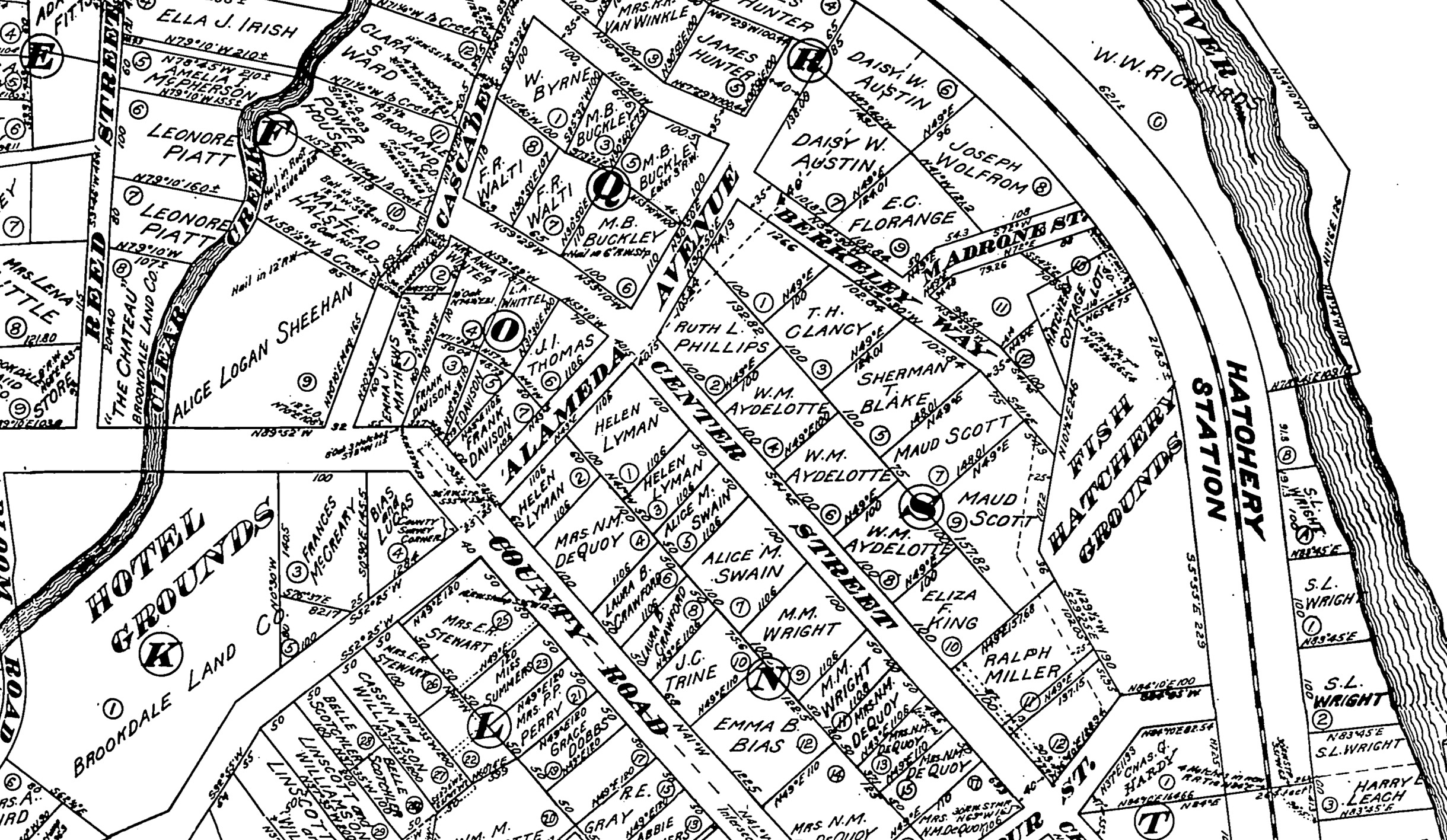
Map of Brookdale (assembled from four tiles), 1910. [Santa Cruz County GIS]

This map above lays out the town in some detail. By this point, Reed's Spur had become the official station for Brookdale and Steen's Spur had become Fish Hatchery. There was also a new station directly across the river to the southeast called Siesta. Notably on this map, the station locations are emphasized, but the spurs and facilities are nowhere mentioned. This map is primarily about property ownership, so other details are lacking. Yet the importance of the railroad line passing through the property development is obvious. The three stations are mentioned and clearly play some role in the life of the community.


Map of Huckleberry Island, April 1903. [Santa Cruz County GIS]

This map of Huckleberry Island is in some ways the opposite of the Brookdale map. The railroad right-of-way is shown, but it is there purely for geographic accuracy, nothing more. The actual railroad passes through an adjacent tract owned by the Hartman family (who are not named on this plan). For whatever reason, no agreement was made with the family and the railroad to allow a flag-stop for Huckleberry Island. Granted, the subdivision was just across a bridge from Brookdale station, but the fact that the developers of the subdivision mostly ignored the railroad in their plans is relevant to understanding the history of this little community.

Excerpt from a revised Map of Brookdale, ca 1911. [Santa Cruz County GIS]

At the other extreme is the above extract from a revision to the 1910 Map of Brookdale. Notice the sudden addition of "North Brookdale Station" at the end of Irwin Way. This station never existed but was rather the fanciful idea of the property developer, surveyor, or cartographer.  Yet the suggestion of such a station is reasonable—this community is separated from Brookdale station by a wide bend in the river putting it 0.9 miles away The next nearest station is Harris (formerly Boulder Mill), which is across the river and therefore inaccessible at this time. Thus, the closest station is actually Filbert 0.8 miles to the north along the main county road (Highway 9). It therefore makes sense that the developer would petition for such a station, but there is no evidence that a station was ever requested and Southern Pacific certainly never established one at this site. Its presence on this map is both evidence of hope and a warning to researchers not to trust everything found on a subdivision plan.

Plan of East Brookdale, August 1909. [Santa Cruz County GIS]

Some of the most useful subdivision plans aren't even necessarily of the specific area in question. This plan of East Brookdale from August 1909 shows Siesta station in detail, despite the fact that it's actually focused on an adjacent subdivision. The plan shows the approximate length of the railroad spur and implies a relationship with the subdivision. Curiously, Siesta is not named, perhaps because the station itself did not have a name at the time this plan was made. The station's prominence in this plan makes clear that it would be available to residents and vacationers to the East Brookdale subdivision. For railroad researchers, it is also very helpful that visual details of the adjacent bridge over the San Lorenzo River are provided, making this plan even more helpful.

Excerpt of the Map of Brookdale, ca 1911. [Santa Cruz County GIS]

Shifting to another use for these maps, they can be used to identify important people, including those who lived on the property before it was subdivided, those who subdivided it, those who lived on it when the map was made, and neighbors to the subdivision. In this random excerpt from the circa 1911 revised Map of Brookdale, several names jump out, some individuals and some businesses. The most important business is the Brookdale Land Company, which subdivided the property on behalf of Judge Logan. Other important property holders include the Fish Hatchery and the Brookdale Lodge. Then there are individuals: Ralph Miller, former co-owner of the Neptune Baths at the Santa Cruz Main Beach; Fred R. Walti, owner of a large slaughterhouse in Santa Cruz; John W. Linscott, superintendent of county schools; and several other people connected to county business and government. All of these may provide clues as to why the subdivision was created, who it hoped to attract, and how the railroad was involved.

Map of the Clear Creek area, 1894. [Santa Cruz County GIS]

One final important use for subdivision plans, town maps, and similar documents is to show a progression. Brookdale was not always a large property subdivision. Once it was just a lumber mill along the county road to Boulder Creek. This map surveyed by E. D. Perry in 1894 shows a very different area than would later emerge. Everything is in a grid pattern corresponding with a standard township division of 36 sections in a 6 mile by 6 mile grid. The railroad bridges are very helpfully numbered, presumably according to the South Pacific Coast Railway's formula. The relationship between the railroad, San Lorenzo River, and county road are much more apparent since there are no small properties confusing the scene. A 'white sulphur spring' is apparently located on the east bank of the river along a small brook. Most importantly, the names of the several large property owners are visible across the page: Grover and Logan, Castle, Ordway, Peterson, and the Hartman Tract. There's also the promise of some development in the area with 'Island Park' already labeled over Huckleberry Island.

Local history resources:

While there are various places you can go to find a few subdivision plans, Santa Cruz County has a one-stop online place to find almost all of them relating to the county. Geographic Information Services (GIS) for Santa Cruz County includes many different maps of the county, but among those are subdivision and other property plans documenting the entire property history of the county.

You can access the GIS Web portal at https://gis.santacruzcounty.us/gisweb. Type in or navigate to a property, click on it (make sure only one property is selected, because it sometimes will click two), and then click on "Recorded Maps & Docs." Under the "Recorded Maps" and "Non Recorded Maps" sections are sometimes dozens of items relating to the property or the larger property within which it is found. Most subdivision plans are under "Recorded Maps," but other things such as rancho boundaries, early area surveys, smaller private subdivisions, and court maps may be found under "Non Recorded Maps." There are also several other categories of maps that may be useful, depending on your topic.

Monterey County has a similar GIS map viewer that can be found here: https://maps.co.monterey.ca.us/portal/apps/webappviewer/index.html?id=a43bf9d208474b7c941a09eeeea7dea2. Unlike the Santa Cruz version, this GIS site shows many of the subdivisions at the overview level and users can see small thumbnails of the available plans and maps when they click on a property. This makes it both more and less convenient to users, depending on how you want to search for your plans.

Unfortunately, Santa Clara and San Benito Counties do not appear to have similarly useful online web tools to search for historical subdivisions and property information. While they have GIS websites, these do not seem to allow for historical breakdowns of properties.

Online map tool:

To assist researchers and those interested in local history, Santa Cruz Trains is created an online map showing all of the ranchos, named subdivisions, and organized towns and cities in Santa Cruz County. The focus currently is on Felton and Ben Lomond, but the map will be expanded to the entire county as time permits.

Friday, July 8, 2022

Sources: Aerial Photographs

The invention of the hot air balloon, photography, and, many years later, airplanes, made capturing the passage in time over a large geographic area much easier. Whereas maps and surveys are incapable of capturing all of the contours and developments in an area with precision and completeness, aerial photographs can capture everything just as it was on the day a kite, balloon, or airplane flew over a specific place and took a photograph. Balloon- and kite-based aerial photographs usually only captured one or a couple photographs of a place, but airplane-based aerial photographs often captured a series of photographs that could later be pieced together to create a long sequence (a mosaic).

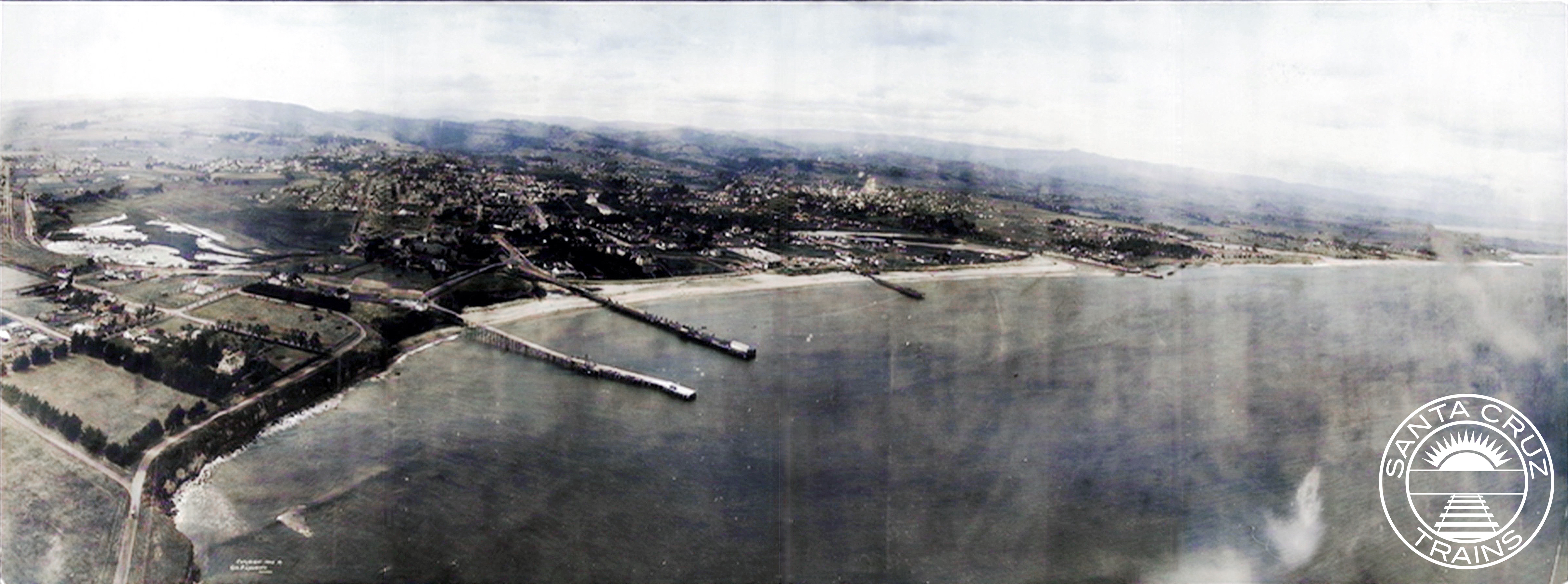
George Lawrence's panoramic photograph of the Santa Cruz Main Beach, 1906. [Bancroft – colorized using DeOldify]

When it comes to researching local history, aerial photography does not always come to mind. And this make sense. Assuming a researcher is looking into the history of a location, the first place they may turn is ground-based photographs. From there, they will likely look into primary and secondary sources, such as newspapers, land deeds, and history books. Even after that, they may turn to more specific visual resources such as fire insurance maps, panoramas and street scene photographs, and family or corporate histories to try and piece together what's missing from the earlier sources. Thus, aerial photographs are often forgotten and, even if not, may be a resource of last resort. That's because they can be difficult to use, are often low resolution, and often do not provide any additional information. Nonetheless, aerial photographs should not be dismissed out of hand.

Ways of using this type of source:

Like with much of the Central Coast of California, local aerial photograph dates to a coastal panorama of the Santa Cruz Main Beach captured by George Lawrence in mid-1906. He began his career using various balloons to take photographs, but after several accidents, he switched to using kites that carried 50 lbs. cameras and took photos with four feet wide negatives. These highly-detailed images were not taken from the top looking straight down, as with later airplane-based photographs, but were taken from about a 35˚ angle, which allows the contours of the horizon and the scale of buildings to be more prominent.

Close-up from the George Lawrence panorama of Bay St. at the Ocean Shore Railway crossing, with Gharkey St. in the foreground, 1906. [Bancroft]

These early aerials are more of a transition from traditional panoramic photography and airplane-based aerial imagery. This lends it the strengths of both. In regard specifically to Lawrence's photograph, you can see several features that a traditional overhead aerial photo would miss, such as the Bay Street bridge over the Ocean Shore Railway's tracks with a wagon passing over it, electrical or telephone lines running along West Cliff Drive, the pilings under the Cowell and Railroad wharves, or more generally the visual styles of the buildings on Beach Hill. Meanwhile, the photo also allows you to view the Santa Cruz Beach and downtown from an angle a traditional photograph would be unable to capture—taken as it is from high above the Point Santa Cruz Lighthouse—and it shows the viewer things that would probably not be photographed, such as how undeveloped the Seabright/Twin Lakes area was or how denuded the hills were of trees. For more on this specific aerial panorama, check out Peter Nurkse's article on the subject here: "Notes on the 1906 Aerial Panorama of Santa Cruz by George Lawrence."

The earliest aerial photograph of Santa Cruz County date to 1928, over twenty years after George Lawrence's kite cameras. The technology used was first tested during World War I, with airplanes flying high over battlefields and behind enemy lines looking for enemy movements and positions. The cameras and how they were mounted onto planes were refined substantially throughout the war but were still not entirely ready for public use afterwards. The cost of the technology alone made it difficult to justify. By the mid-1920s, though, aerial photography planes—many of them war surplus—became available for commercial use and several companies popped up across the United States to capture aerial images for use by local governments, companies, and individuals. Many of the early aerial photographs of Santa Cruz County were captured by Fairchild Aerial Surveys, incorporated in 1924.

1931 aerial photograph showing the remnants of the Ocean Shore Railroad right-of-way from Bay St. (top right) to Delaware Ave. (far left). [UC Santa Barbara]

Aerial photographs by their very nature need to be high-resolution. Thus, even in the 1920s, they show a high degree of detail. Their primary use in research is to identify when specific structures or other features visible from the air first were built and how they were situated. Parcels are quite often distinct due to boundary fences, roads, agricultural plantings, and different yard layouts, meaning that aerial photographs can be quite useful in determining the physical boundaries of an estate or business. They also can show to some degree the layout and quality of roads, waterways, railroads, and other human-made topographical features.

Over the decades, the quality of film changed, especially following World War II, when aerial photography shifted from a convenient tool for reconnaissance into a precision bomb-targeting tool. As before, technological improvements quickly dispersed from the military after the war into the public and private sectors. Thus, aerial photographs from the 1950s and 1960s are often of a very high quality, even by today's standards. From the early 1970s onward, color photographs increasingly replaced two-tone, allowing researchers to see an even greater range of details in the photographs. This remained the state of aerial photography more or less into the late 1990s.

Aerial photograph of Laguna St. and the former Ocean Shore Railroad right-of-way, ca 1964. [UC Santa Barbara]

One of the major features of later twentieth century aerial photograph was higher contrast photographs. In the first half of the century, photos were usually pretty flat, with shadows muted and even many details slightly fuzzy. World War II aerial photographers realized that higher shutter speeds could capture sharper images. This also resulted in sharper shadows and generally brighter photographs. Certain details, such as color shading on roofs and fields could be better discerned, often making property boundary markers easier to see, and features such as automobiles and railroad tracks also became more visible.

The late 1990s and especially the early 2000s had the most substantial shift in aerial photography in that it shifted from the troposphere to the exosphere. The first such global positioning system (GPS) satellites went into the upper atmosphere in the late 1970s, but it was not available to the public until the mid-1980s and not widely until 2000. The rapid expansion of GPS meant that commercial firms, non-profits, and public government agencies could take high-resolution photographs from space and send them back to earth. These can be taken constantly and are stored digitally, so they do not require the same type of infrastructure—planes, film, and photo paper—to maintain. While a few companies still capture aerial photographs in the old manner, this is usually done for specifically outlined reasons and the results are often not made public. The most recent airplane-based aerial survey of Santa Cruz County was made in 2003.

Google Maps satellite image showing Laguna St. and Delaware Ave., ca 2016. [Google Maps]

There are several different websites and applications that allow people to view GPS-recorded photographs, but none are more popular than Google Maps and Google Earth. Indeed, Google Maps always maintains two separate sets of satellite images, one called "Globe View" (which also allows for an artificial 3D effect based on stereoscopic technology) and one simply called "Satellite." The desktop app version of Google Earth, meanwhile, allows for limited historical views, which are made up of old airplane-based mosaics superimposed on an otherwise modern map. The benefits of Google Maps and Earth are obvious: a user can zoom in quite close with quite a good level of detail and then quickly move somewhere else without having to find another photograph or mosaic. The aerial photographs are so seamlessly sewn that you often don't even know you're looking at thousands of overlapping images. The compression factor in the file sizes also means that you don't have to download huge TIFF files to view details, as you do with traditional aerial photographs, and the color quality is maintained since the images are digitally native.

For researchers, there are many reasons why satellite imagery is superior. The color and level of detail often far outpace traditional aerial photographs. If you can find historical satellite aerials, such as on the Google Earth desktop app, you can see progressions of development in an area over a relatively short space of time. Even by comparing the two different Google Maps layers—"Globe View" vs. "Satellite"—you can see changes, since the two maps do not reflect the same exact moment in time and may be a few years different.

Whether you are looking at kite panoramas from 1906 or Google Maps from 2022, aerial photographs can be helpful when doing local history research. These photographs, unlike almost any other resource, depict visual representations of change over a long period of time. They can show urbanization, the expansion of roads and railroads, the development or collapse of industries, and even the damage caused by natural disasters. And unlike so many other sources, they show things agnostically: an aerial photo captures both the target of its attention and all the details around it, which sometimes is a lot.

Downsides and problems with this type of source:

Just because aerial photographs can be extremely helpful in research doesn't mean they don't have problems. Earlier aerial photos suffered from several issues. They depicted both a larger and a smaller area than airplane-based aerial photos—larger because they could see beyond the range of a top-down photograph, smaller because the details become increasingly difficult to discern the further the camera is from the subject. Airplane-based aerial photos capture everything from the same distance more or less. Earlier panorama aerials also were taken far enough away that individual details can't always be made out, such as business names, the routes of roads that may be obscured by buildings or trees, or the nature of features far in the distance.

Low-resolution aerial photograph of Laguna St. and the Ocean Shore Railroad right-of-way, 1957. [UC Santa Barbara]

Airplane-based aerial photographs became the standard from the 1920s and had several of their own issues. First and foremost, it is almost impossible to gauge depth on a single aerial photograph, especially in the first half of the century. While multiple photographs can be turned into stereographs—a technique used by the military to gauge the terrain and size of buildings—single photos just show rooftops. Thus, you can't get much detail from them regarding the style and makeup of structures except for their physical location, footprint, and maybe their roofing type. Similarly, other features such as trees and gardens, vehicles, and even roads can be difficult to discern. Roads can often be obscured by tree cover and railroads are sometimes too pale against the landscape to follow with accuracy. These issues improved after World War II, but they never disappeared entirely.

Low-resolution color aerial photograph of Laguna St. and Delaware Ave., 1972. [UC Santa Barbara]

A strange step-back occurred in the 1970s, as an increasing number of aerial photography cameras shifted to using color film. While adding color had its benefits, the film quality itself was often subpar, rendering blurrier photographs and low resolutions. Color film also had a strong tendency to fade over a relatively short period of time, especially when left out in any light. This problem persisted throughout the entirety of the color film period until digital photography replaced film in the early 2000s. In most cases and despite its clear downsides, two-tone photographs are often better for researching aerial photographs. Another problem with all film-based photography is that high-resolution versions are saved in TIFF files, which are immense, slow to download, and often difficult to browse online.

Color aerial photograph of Laguna St. and Delaware Ave., 2001. [UC Santa Barbara]

Satellite imagery has many different problems from its predecessors. Since satellite images today are all digital, the color doesn't fade. Also, compression software means loading the images is less of a problem. Downloading the images, however, is nearly impossible now since the mosaics are no longer separable—they are glued together prior to uploading. So if a person wants a satellite image of a place, they must use screen captures, which can be tedious and breaks copyright. Earlier satellite photos, such as those from the 1990s and early 2000s, are also often poor quality since the digital images were not yet of a sufficient quality. Even more problematic, though, it is often impossible to determine the precise date that a specific satellite image was taken since it is often a mosaic composed of several different photos taken over an unspecified period of time. For example, the "Globe View" of the Santa Cruz Beach Boardwalk right now still shows the park's pre-2016 configuration, while the "Satellite" view shows its current layout.

3D technologies such as that used on Google Maps and Google Earth also sometimes distort things, making them appear different than they truly are. The superimposition of street Labels, too, can cause unconscious problems by giving you a false sense of a street's history based on its modern name. It's often a good idea to turn off Labels when researching if you feel it may distract. The seamlessness of Google Street View is another potential problem in that, much like the different aerial views, it may glue together photographs from several different photo shoots but gives you a sense of continuity. The Street View of the Boardwalk, for example, was taken in 2011, which fortunately is noted at the bottom of the screen.

Like all research resources, aerial photographs have their upsides and their downsides. In many cases, they are tools of last resort, but they should not be dismissed out of hand. Just be cautious when using them and remember that they depict a specific time and place and not everything may be as it appears.

Local History Resources:

The following is a selection of California-specific aerial photograph databases that have material available online. It is by no means a complete list and more material may be added as it is discovered or made available digitally.

UC Santa Barbara Library's Aerial Photography database

By far the most accessible source for California-specific aerial photographs is UC Santa Barbara Library's Aerial Photography database (https://www.library.ucsb.edu/geospatial/aerial-photography). This repository includes millions of mosaics and individual aerial photographs from throughout the state and many of them can be downloaded for free directly from the website. The FrameFinder tool is the easiest means of finding photos, although it can be quite overwhelming. Individual dots are placed on the map, each oof which represents an aerial photograph, usually part of a larger mosaic. You can click the Flight ID record for information relating to the flight, including usually a list of all of the photographs that are include in the mosaic and their individual record numbers. More simply, you can click the Free Download link beside Scan to see and download the photograph. The FrameFinder is currently the best way of accessing photographs, unfortunately, because the other method—the AP Flights Catalog—doesn't allow you to select individual photographs to view.

Fresno State University Henry Madden Library's Map and Aerial Photograph Collections

Fresno State University has its own collection of maps and aerial photographs (https://guides.library.fresnostate.edu/mapcollections/aerialphotocollection) that cover all of California, although their collection is far less extensive than UC Santa Barbara's. Its MALT indexing tool is regrettably only useful for the Fresno area, so users from outside that area must search for photos from the Digitized Collections website, which can be more tedious. Nonetheless, nearly 4,000 photographs are available of Santa Cruz County ranging from 1937 to 1993.

UC Santa Cruz University Library's Maps & Aerial Photos database (currently offline)

The most convenient option would be to access UC Santa Cruz's collection of maps and aerial photographs (https://guides.library.ucsc.edu/maps), but unfortunately the digitized photographs were taken down in 2020 and are still not back online. It is still possible to look through the Aerial Photo Flight Indexes to determine if UCSC has a photograph you need for your research. The index PDFs include specific details of the flight an the customized maps on the pages allow you to identify precisely what photograph would be the most useful.

Google Maps and Google Earth

The easiest and two of the best options for accessing current and near-current satellite photographs of Santa Cruz County are Google Maps (https://www.google.com/maps/) and Google Earth (https://earth.google.com/web/). On Google Maps, to avoid distraction, turn off Labels, and for the most recent map turn off "Globe View" (this will also avoid the 3D effect and avoid you accidentally going to Street View). Capturing images from it is a pain, so use your computer's screen capture app. Also remember that all Google Maps are under copyright, so using them in commercial products is legally not allowed.