
The invention of the hot air balloon, photography, and, many years later, airplanes, made capturing the passage in time over a large geographic area much easier. Whereas maps and surveys are incapable of capturing all of the contours and developments in an area with precision and completeness, aerial photographs can capture everything just as it was on the day a kite, balloon, or airplane flew over a specific place and took a photograph. Balloon- and kite-based aerial photographs usually only captured one or a couple photographs of a place, but airplane-based aerial photographs often captured a series of photographs that could later be pieced together to create a long sequence (a mosaic).
 |
| George Lawrence's panoramic photograph of the Santa Cruz Main Beach, 1906. [Bancroft – colorized using DeOldify] |
When it comes to researching local history, aerial photography does not always come to mind. And this make sense. Assuming a researcher is looking into the history of a location, the first place they may turn is ground-based photographs. From there, they will likely look into primary and secondary sources, such as newspapers, land deeds, and history books. Even after that, they may turn to more specific visual resources such as fire insurance maps, panoramas and street scene photographs, and family or corporate histories to try and piece together what's missing from the earlier sources. Thus, aerial photographs are often forgotten and, even if not, may be a resource of last resort. That's because they can be difficult to use, are often low resolution, and often do not provide any additional information. Nonetheless, aerial photographs should not be dismissed out of hand.
Ways of using this type of source:
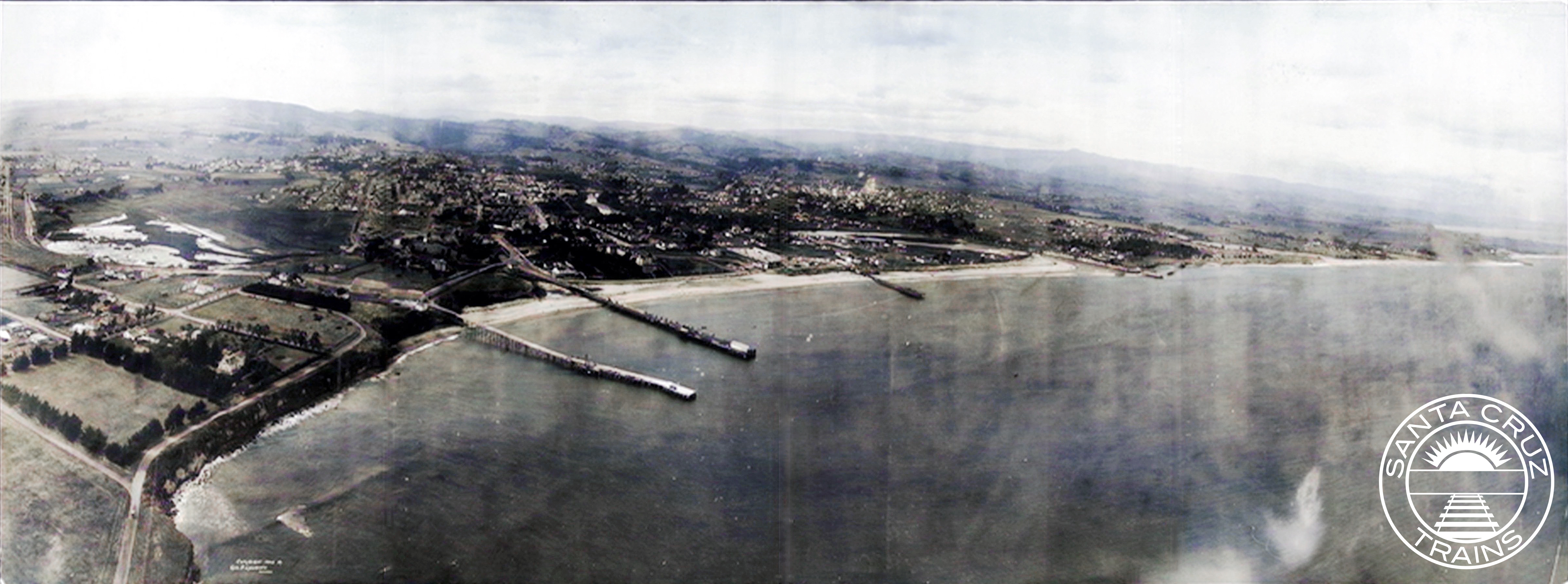
Like with much of the Central Coast of California, local aerial photograph dates to a coastal panorama of the Santa Cruz Main Beach captured by George Lawrence in mid-1906. He began his career using various balloons to take photographs, but after several accidents, he switched to using kites that carried 50 lbs. cameras and took photos with four feet wide negatives. These highly-detailed images were not taken from the top looking straight down, as with later airplane-based photographs, but were taken from about a 35˚ angle, which allows the contours of the horizon and the scale of buildings to be more prominent.
 |
| Close-up from the George Lawrence panorama of Bay St. at the Ocean Shore Railway crossing, with Gharkey St. in the foreground, 1906. [Bancroft] |
These early aerials are more of a transition from traditional panoramic photography and airplane-based aerial imagery. This lends it the strengths of both. In regard specifically to Lawrence's photograph, you can see several features that a traditional overhead aerial photo would miss, such as the Bay Street bridge over the Ocean Shore Railway's tracks with a wagon passing over it, electrical or telephone lines running along West Cliff Drive, the pilings under the Cowell and Railroad wharves, or more generally the visual styles of the buildings on Beach Hill. Meanwhile, the photo also allows you to view the Santa Cruz Beach and downtown from an angle a traditional photograph would be unable to capture—taken as it is from high above the Point Santa Cruz Lighthouse—and it shows the viewer things that would probably not be photographed, such as how undeveloped the Seabright/Twin Lakes area was or how denuded the hills were of trees. For more on this specific aerial panorama, check out Peter Nurkse's article on the subject here: "Notes on the 1906 Aerial Panorama of Santa Cruz by George Lawrence."
The earliest aerial photograph of Santa Cruz County date to 1928, over twenty years after George Lawrence's kite cameras. The technology used was first tested during World War I, with airplanes flying high over battlefields and behind enemy lines looking for enemy movements and positions. The cameras and how they were mounted onto planes were refined substantially throughout the war but were still not entirely ready for public use afterwards. The cost of the technology alone made it difficult to justify. By the mid-1920s, though, aerial photography planes—many of them war surplus—became available for commercial use and several companies popped up across the United States to capture aerial images for use by local governments, companies, and individuals. Many of the early aerial photographs of Santa Cruz County were captured by Fairchild Aerial Surveys, incorporated in 1924.
 |
| 1931 aerial photograph showing the remnants of the Ocean Shore Railroad right-of-way from Bay St. (top right) to Delaware Ave. (far left). [UC Santa Barbara] |
Aerial photographs by their very nature need to be high-resolution. Thus, even in the 1920s, they show a high degree of detail. Their primary use in research is to identify when specific structures or other features visible from the air first were built and how they were situated. Parcels are quite often distinct due to boundary fences, roads, agricultural plantings, and different yard layouts, meaning that aerial photographs can be quite useful in determining the physical boundaries of an estate or business. They also can show to some degree the layout and quality of roads, waterways, railroads, and other human-made topographical features.
Over the decades, the quality of film changed, especially following World War II, when aerial photography shifted from a convenient tool for reconnaissance into a precision bomb-targeting tool. As before, technological improvements quickly dispersed from the military after the war into the public and private sectors. Thus, aerial photographs from the 1950s and 1960s are often of a very high quality, even by today's standards. From the early 1970s onward, color photographs increasingly replaced two-tone, allowing researchers to see an even greater range of details in the photographs. This remained the state of aerial photography more or less into the late 1990s.
 |
| Aerial photograph of Laguna St. and the former Ocean Shore Railroad right-of-way, ca 1964. [UC Santa Barbara] |
One of the major features of later twentieth century aerial photograph was higher contrast photographs. In the first half of the century, photos were usually pretty flat, with shadows muted and even many details slightly fuzzy. World War II aerial photographers realized that higher shutter speeds could capture sharper images. This also resulted in sharper shadows and generally brighter photographs. Certain details, such as color shading on roofs and fields could be better discerned, often making property boundary markers easier to see, and features such as automobiles and railroad tracks also became more visible.
The late 1990s and especially the early 2000s had the most substantial shift in aerial photography in that it shifted from the troposphere to the exosphere. The first such global positioning system (GPS) satellites went into the upper atmosphere in the late 1970s, but it was not available to the public until the mid-1980s and not widely until 2000. The rapid expansion of GPS meant that commercial firms, non-profits, and public government agencies could take high-resolution photographs from space and send them back to earth. These can be taken constantly and are stored digitally, so they do not require the same type of infrastructure—planes, film, and photo paper—to maintain. While a few companies still capture aerial photographs in the old manner, this is usually done for specifically outlined reasons and the results are often not made public. The most recent airplane-based aerial survey of Santa Cruz County was made in 2003.
.png) |
| Google Maps satellite image showing Laguna St. and Delaware Ave., ca 2016. [Google Maps] |
There are several different websites and applications that allow people to view GPS-recorded photographs, but none are more popular than Google Maps and Google Earth. Indeed, Google Maps always maintains two separate sets of satellite images, one called "Globe View" (which also allows for an artificial 3D effect based on stereoscopic technology) and one simply called "Satellite." The desktop app version of Google Earth, meanwhile, allows for limited historical views, which are made up of old airplane-based mosaics superimposed on an otherwise modern map. The benefits of Google Maps and Earth are obvious: a user can zoom in quite close with quite a good level of detail and then quickly move somewhere else without having to find another photograph or mosaic. The aerial photographs are so seamlessly sewn that you often don't even know you're looking at thousands of overlapping images. The compression factor in the file sizes also means that you don't have to download huge TIFF files to view details, as you do with traditional aerial photographs, and the color quality is maintained since the images are digitally native.
For researchers, there are many reasons why satellite imagery is superior. The color and level of detail often far outpace traditional aerial photographs. If you can find historical satellite aerials, such as on the Google Earth desktop app, you can see progressions of development in an area over a relatively short space of time. Even by comparing the two different Google Maps layers—"Globe View" vs. "Satellite"—you can see changes, since the two maps do not reflect the same exact moment in time and may be a few years different.
Whether you are looking at kite panoramas from 1906 or Google Maps from 2022, aerial photographs can be helpful when doing local history research. These photographs, unlike almost any other resource, depict visual representations of change over a long period of time. They can show urbanization, the expansion of roads and railroads, the development or collapse of industries, and even the damage caused by natural disasters. And unlike so many other sources, they show things agnostically: an aerial photo captures both the target of its attention and all the details around it, which sometimes is a lot.
Downsides and problems with this type of source:
Just because aerial photographs can be extremely helpful in research doesn't mean they don't have problems. Earlier aerial photos suffered from several issues. They depicted both a larger and a smaller area than airplane-based aerial photos—larger because they could see beyond the range of a top-down photograph, smaller because the details become increasingly difficult to discern the further the camera is from the subject. Airplane-based aerial photos capture everything from the same distance more or less. Earlier panorama aerials also were taken far enough away that individual details can't always be made out, such as business names, the routes of roads that may be obscured by buildings or trees, or the nature of features far in the distance.
 |
| Low-resolution aerial photograph of Laguna St. and the Ocean Shore Railroad right-of-way, 1957. [UC Santa Barbara] |
Airplane-based aerial photographs became the standard from the 1920s and had several of their own issues. First and foremost, it is almost impossible to gauge depth on a single aerial photograph, especially in the first half of the century. While multiple photographs can be turned into stereographs—a technique used by the military to gauge the terrain and size of buildings—single photos just show rooftops. Thus, you can't get much detail from them regarding the style and makeup of structures except for their physical location, footprint, and maybe their roofing type. Similarly, other features such as trees and gardens, vehicles, and even roads can be difficult to discern. Roads can often be obscured by tree cover and railroads are sometimes too pale against the landscape to follow with accuracy. These issues improved after World War II, but they never disappeared entirely.
 |
| Low-resolution color aerial photograph of Laguna St. and Delaware Ave., 1972. [UC Santa Barbara] |
A strange step-back occurred in the 1970s, as an increasing number of aerial photography cameras shifted to using color film. While adding color had its benefits, the film quality itself was often subpar, rendering blurrier photographs and low resolutions. Color film also had a strong tendency to fade over a relatively short period of time, especially when left out in any light. This problem persisted throughout the entirety of the color film period until digital photography replaced film in the early 2000s. In most cases and despite its clear downsides, two-tone photographs are often better for researching aerial photographs. Another problem with all film-based photography is that high-resolution versions are saved in TIFF files, which are immense, slow to download, and often difficult to browse online.
 |
| Color aerial photograph of Laguna St. and Delaware Ave., 2001. [UC Santa Barbara] |
Satellite imagery has many different problems from its predecessors. Since satellite images today are all digital, the color doesn't fade. Also, compression software means loading the images is less of a problem. Downloading the images, however, is nearly impossible now since the mosaics are no longer separable—they are glued together prior to uploading. So if a person wants a satellite image of a place, they must use screen captures, which can be tedious and breaks copyright. Earlier satellite photos, such as those from the 1990s and early 2000s, are also often poor quality since the digital images were not yet of a sufficient quality. Even more problematic, though, it is often impossible to determine the precise date that a specific satellite image was taken since it is often a mosaic composed of several different photos taken over an unspecified period of time. For example, the "Globe View" of the Santa Cruz Beach Boardwalk right now still shows the park's pre-2016 configuration, while the "Satellite" view shows its current layout.
3D technologies such as that used on Google Maps and Google Earth also sometimes distort things, making them appear different than they truly are. The superimposition of street Labels, too, can cause unconscious problems by giving you a false sense of a street's history based on its modern name. It's often a good idea to turn off Labels when researching if you feel it may distract. The seamlessness of Google Street View is another potential problem in that, much like the different aerial views, it may glue together photographs from several different photo shoots but gives you a sense of continuity. The Street View of the Boardwalk, for example, was taken in 2011, which fortunately is noted at the bottom of the screen.
Like all research resources, aerial photographs have their upsides and their downsides. In many cases, they are tools of last resort, but they should not be dismissed out of hand. Just be cautious when using them and remember that they depict a specific time and place and not everything may be as it appears.
Local History Resources:
The following is a selection of California-specific aerial photograph databases that have material available online. It is by no means a complete list and more material may be added as it is discovered or made available digitally.
UC Santa Barbara Library's Aerial Photography database
By far the most accessible source for California-specific aerial photographs is UC Santa Barbara Library's Aerial Photography database (https://www.library.ucsb.edu/geospatial/aerial-photography). This repository includes millions of mosaics and individual aerial photographs from throughout the state and many of them can be downloaded for free directly from the website. The FrameFinder tool is the easiest means of finding photos, although it can be quite overwhelming. Individual dots are placed on the map, each oof which represents an aerial photograph, usually part of a larger mosaic. You can click the Flight ID record for information relating to the flight, including usually a list of all of the photographs that are include in the mosaic and their individual record numbers. More simply, you can click the Free Download link beside Scan to see and download the photograph. The FrameFinder is currently the best way of accessing photographs, unfortunately, because the other method—the AP Flights Catalog—doesn't allow you to select individual photographs to view.
Fresno State University Henry Madden Library's Map and Aerial Photograph Collections
UC Santa Cruz University Library's Maps & Aerial Photos database (currently offline)
The most convenient option would be to access UC Santa Cruz's collection of maps and aerial photographs (https://guides.library.ucsc.edu/maps), but unfortunately the digitized photographs were taken down in 2020 and are still not back online. It is still possible to look through the Aerial Photo Flight Indexes to determine if UCSC has a photograph you need for your research. The index PDFs include specific details of the flight an the customized maps on the pages allow you to identify precisely what photograph would be the most useful.
Google Maps and Google Earth
The easiest and two of the best options for accessing current and near-current satellite photographs of Santa Cruz County are Google Maps (https://www.google.com/maps/) and Google Earth (https://earth.google.com/web/). On Google Maps, to avoid distraction, turn off Labels, and for the most recent map turn off "Globe View" (this will also avoid the 3D effect and avoid you accidentally going to Street View). Capturing images from it is a pain, so use your computer's screen capture app. Also remember that all Google Maps are under copyright, so using them in commercial products is legally not allowed.
No comments:
Post a Comment
Note: Only a member of this blog may post a comment.