
Almost every property in Santa Cruz County and in the surrounding areas was once a part of a larger property. On the coast and in the Pajaro Valley, most of these were Mexican ranchos. Elsewhere, they were large land grants, often in nearly uninhabitable mountain terrain. Eventually, the forests were cut down, the swamps were drained, and roads were extended, making much of the land in the region usable by settlers. Over time, the large ranchos and tracts were subdivided into smaller, more manageable properties. And the plans of these subdivisions can be very useful in researching local railroad history.
The railroads of the Santa Cruz Mountains passed through several large properties. These included the coastal ranchos, the Pajaro Valley ranchos, Ranchos Zayante and Rincon on the San Lorenzo River, and Rancho Rinconada de los Gatos in Santa Clara County. Other large tracts through which railroads passed include the Santa Clara Valley Mill & Lumber Company's properties high up Zayante Creek, the Pacific Manufacturing Company's properties in the Ben Lomond area, Grover & Company's lands around Brookdale, and the various timber companies that owned property in and north of Boulder Creek. When the early railroads built their routes, these were still large property blocks, so negotiating easements and rights-of-way were relatively straightforward. However, as time passed, these large properties shrunk and subdivisions were created, often directly beside or around the railroad tracks.
A property developer creating a new subdivision can deal with the presence of a railroad in a number of ways:
- In select cases, they may petition the Southern Pacific Railroad to create a dedicated station for their subdivision. This is how Glen Arbor, Olympia, Call of the Wild, and Seabright all obtained their stations. Similarly, resorts such as the Boardwalk, Mount Hermon, Twin Lakes, Eva, and Manresa were allowed stations because the resort owners petitioned the railroad.
- Alternatively, a subdivision may be created around an already-established station, with the property developers integrating the station into its plans (and the name sometimes changing as a result). This occurred at Eccles, Meehan (formerly Doughertys), Farley (Claus), Glenwood, Laurel (Highland), and elsewhere. In some cases, large-scale communities developed around former freight stations, such as at Ben Lomond (Pacific Mills), Brookdale (Reed's Spur), Aromas (Sand Cut), and Capitola (Soquel).
- In the majority of cases, the property is subdivided with acceptance of the adjacent railroad but no active engagement with it. Sometimes proximity to a nearby railroad station is offered as a perk, other times the railroad goes entirely unmentioned. And in rare instances, it is left off the subdivision plan itself, suggesting that the developer wanted to downplay the presence of the railroad.
Ways of using this type of source:
When it comes to railroad research, the number one reason to view a subdivision plan is to see how the property developers intended to interact with the railroad right-of-way. The area around Brookdale in the San Lorenzo Valley provides several different examples demonstrating the various relationships. Brookdale was developed from the land of Grover & Company, a lumber company, which had been purchased in the late 1890s by James Harvey Logan, a superior court judge. At the time, there were two train stations in the area: Reed's Spur and Steen's Spur. Both of these were industrial spurs catering to local logging operations, which had shut down by the time Logan had purchased the property.
 |
| Map of Brookdale (assembled from four tiles), 1910. [Santa Cruz County GIS] |
This map above lays out the town in some detail. By this point, Reed's Spur had become the official station for Brookdale and Steen's Spur had become Fish Hatchery. There was also a new station directly across the river to the southeast called Siesta. Notably on this map, the station locations are emphasized, but the spurs and facilities are nowhere mentioned. This map is primarily about property ownership, so other details are lacking. Yet the importance of the railroad line passing through the property development is obvious. The three stations are mentioned and clearly play some role in the life of the community.
 |
| Map of Huckleberry Island, April 1903. [Santa Cruz County GIS] |
This map of Huckleberry Island is in some ways the opposite of the Brookdale map. The railroad right-of-way is shown, but it is there purely for geographic accuracy, nothing more. The actual railroad passes through an adjacent tract owned by the Hartman family (who are not named on this plan). For whatever reason, no agreement was made with the family and the railroad to allow a flag-stop for Huckleberry Island. Granted, the subdivision was just across a bridge from Brookdale station, but the fact that the developers of the subdivision mostly ignored the railroad in their plans is relevant to understanding the history of this little community.
 |
| Excerpt from a revised Map of Brookdale, ca 1911. [Santa Cruz County GIS] |
At the other extreme is the above extract from a revision to the 1910 Map of Brookdale. Notice the sudden addition of "North Brookdale Station" at the end of Irwin Way. This station never existed but was rather the fanciful idea of the property developer, surveyor, or cartographer. Yet the suggestion of such a station is reasonable—this community is separated from Brookdale station by a wide bend in the river putting it 0.9 miles away The next nearest station is Harris (formerly Boulder Mill), which is across the river and therefore inaccessible at this time. Thus, the closest station is actually Filbert 0.8 miles to the north along the main county road (Highway 9). It therefore makes sense that the developer would petition for such a station, but there is no evidence that a station was ever requested and Southern Pacific certainly never established one at this site. Its presence on this map is both evidence of hope and a warning to researchers not to trust everything found on a subdivision plan.
 |
| Plan of East Brookdale, August 1909. [Santa Cruz County GIS] |
Some of the most useful subdivision plans aren't even necessarily of the specific area in question. This plan of East Brookdale from August 1909 shows Siesta station in detail, despite the fact that it's actually focused on an adjacent subdivision. The plan shows the approximate length of the railroad spur and implies a relationship with the subdivision. Curiously, Siesta is not named, perhaps because the station itself did not have a name at the time this plan was made. The station's prominence in this plan makes clear that it would be available to residents and vacationers to the East Brookdale subdivision. For railroad researchers, it is also very helpful that visual details of the adjacent bridge over the San Lorenzo River are provided, making this plan even more helpful.
 |
| Excerpt of the Map of Brookdale, ca 1911. [Santa Cruz County GIS] |
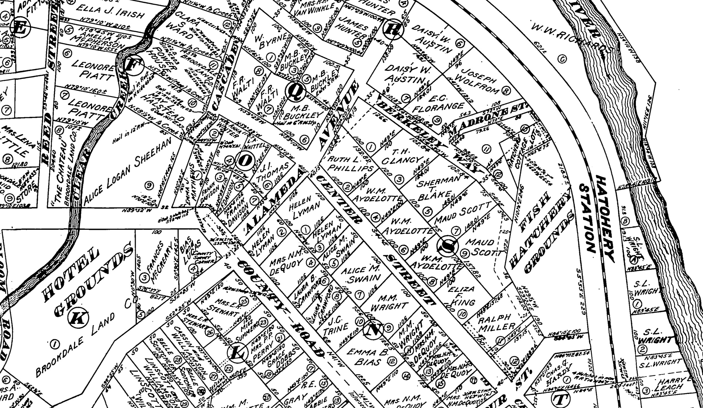
Shifting to another use for these maps, they can be used to identify important people, including those who lived on the property before it was subdivided, those who subdivided it, those who lived on it when the map was made, and neighbors to the subdivision. In this random excerpt from the circa 1911 revised Map of Brookdale, several names jump out, some individuals and some businesses. The most important business is the Brookdale Land Company, which subdivided the property on behalf of Judge Logan. Other important property holders include the Fish Hatchery and the Brookdale Lodge. Then there are individuals: Ralph Miller, former co-owner of the Neptune Baths at the Santa Cruz Main Beach; Fred R. Walti, owner of a large slaughterhouse in Santa Cruz; John W. Linscott, superintendent of county schools; and several other people connected to county business and government. All of these may provide clues as to why the subdivision was created, who it hoped to attract, and how the railroad was involved.
| Map of the Clear Creek area, 1894. [Santa Cruz County GIS] |
One final important use for subdivision plans, town maps, and similar documents is to show a progression. Brookdale was not always a large property subdivision. Once it was just a lumber mill along the county road to Boulder Creek. This map surveyed by E. D. Perry in 1894 shows a very different area than would later emerge. Everything is in a grid pattern corresponding with a standard township division of 36 sections in a 6 mile by 6 mile grid. The railroad bridges are very helpfully numbered, presumably according to the South Pacific Coast Railway's formula. The relationship between the railroad, San Lorenzo River, and county road are much more apparent since there are no small properties confusing the scene. A 'white sulphur spring' is apparently located on the east bank of the river along a small brook. Most importantly, the names of the several large property owners are visible across the page: Grover and Logan, Castle, Ordway, Peterson, and the Hartman Tract. There's also the promise of some development in the area with 'Island Park' already labeled over Huckleberry Island.
Local history resources:
While there are various places you can go to find a few subdivision plans, Santa Cruz County has a one-stop online place to find almost all of them relating to the county. Geographic Information Services (GIS) for Santa Cruz County includes many different maps of the county, but among those are subdivision and other property plans documenting the entire property history of the county.
You can access the GIS Web portal at https://gis.santacruzcounty.us/gisweb. Type in or navigate to a property, click on it (make sure only one property is selected, because it sometimes will click two), and then click on "Recorded Maps & Docs." Under the "Recorded Maps" and "Non Recorded Maps" sections are sometimes dozens of items relating to the property or the larger property within which it is found. Most subdivision plans are under "Recorded Maps," but other things such as rancho boundaries, early area surveys, smaller private subdivisions, and court maps may be found under "Non Recorded Maps." There are also several other categories of maps that may be useful, depending on your topic.
Monterey County has a similar GIS map viewer that can be found here: https://maps.co.monterey.ca.us/portal/apps/webappviewer/index.html?id=a43bf9d208474b7c941a09eeeea7dea2. Unlike the Santa Cruz version, this GIS site shows many of the subdivisions at the overview level and users can see small thumbnails of the available plans and maps when they click on a property. This makes it both more and less convenient to users, depending on how you want to search for your plans.
Unfortunately, Santa Clara and San Benito Counties do not appear to have similarly useful online web tools to search for historical subdivisions and property information. While they have GIS websites, these do not seem to allow for historical breakdowns of properties.
Online map tool:
To assist researchers and those interested in local history, Santa Cruz Trains is created an online map showing all of the ranchos, named subdivisions, and organized towns and cities in Santa Cruz County. The focus currently is on Felton and Ben Lomond, but the map will be expanded to the entire county as time permits.
No comments:
Post a Comment
Note: Only a member of this blog may post a comment.