Showing posts with label Coast Line Railroad. Show all posts

Thursday, August 27, 2026

Stations: Orby

Orby served as the Coast Line Railway’s primary team track south of Davenport, where rolling stock could park along its 2,600-foot-long (52 carlengths) siding that ran from a point slightly east of Swift Street to just before the Cliff Drive (now Natural Bridges Drive) crossing. The station itself was located west of Swift Street and featured a sign and a platform, but no other facilities. Though few people lived in the vicinity of the station, passengers could flag trains or stop there. What other purpose Orby served when it was established is unknown, yet the Ocean Shore Railway a quarter mile to the south clearly saw the same potential. The Shore Line Investment Company, Ocean Shore’s real estate subsidiary, had purchased 35 acres of Louis C. Rapetta’s ranch in June 1905, though what the company planned to do with this is unknown. When the San Vicente Lumber Company began scouting for sites to erect a massive lumber mill, Ocean Shore offered the ranch, which, after some bureaucratic delays, the company accepted. The location was directly between the lines of the Ocean Shore Railway—which set up a station named Rapetti sometime in mid-1908—and the Coast Line Railway’s Orby station.

The Wm. Wrigley Jr. Company factory on Mission Street on the West Side of Santa Cruz, circa 1955. [Courtesy University of California, Santa Cruz – colorized using MyHeritage]

The San Vicente Lumber Company’s mill and yard quickly evolved into an interchange between the two railroads. A long, curving track passed through the yard, linking the lines and eliminating the need for the junction further west at Wilder’s Ranch. Trackage within the mill property catered to both railroads. Ocean Shore maintained a siding that ran along the north side of the Moore Creek fill to allow carloads of timber to be dumped into the adjacent millpond (today’s Antonelli Pond). Another spur supported a repair shop for the lumber company’s rolling stock, while a car shed straddled the main track through the yard. On the northern end of the property, two spurs connected to the main track just before its connection with the Coast Line Railway. These spurs allowed cars to be rolled directly from the lumber stacks to Orby’s siding, where the daily freight train collected them.

San Vicente Lumber Company viewed northeast from the Ocean Shore tracks across the log pond, circa 1920. [UC Santa Cruz – colorized using MyHeritage]

After the Ocean Shore Railroad collapsed in late 1920, the San Vicente Lumber Company took over most of the line and ran it until early 1923. By this time, the Santa Cruz Portland Cement Company plant in Davenport had extensive trackage and there was little need for the extra siding space at Orby. In response, Southern Pacific reduced its siding length to 43 carlengths in May 1923. However, a new freight customer arrived on the scene just in time to save the station. In November 1922, Walti, Schilling & Company acquired 70 acres from Stella Tolle west of Moore Creek on Shaffer Road. The company needed to replace its aging slaughterhouse and stockyard on 7th Avenue near Twin Lakes and this new location outside the city limits, on a large tract, and directly alongside the Davenport Branch, was a perfect solution. The company only needed 10 acres for its cold storage plant and modern slaughterhouse, so it leased the remaining acreage to G. Marcucci and P. Guidotti, who planned to grow artichokes on the property. The Walti–Schilling plant opened in late 1923, supported by a private spur installed by Southern Pacific.

The fire at the Coast Drum and Box Company factory on Mission Street, September 4, 1953. [Santa Cruz Sentinel-News – colorized using MyHeritage]

Although Orby maintained a flag stop until the end of passenger service on the Davenport Branch in 1932, few people lived around the station or called trains there. In 1936, the Santa Cruz City Council rezoned the area around the spur for industrial use, opening it up for development. The first customer was John L. Debenedetti, who negotiated with the Union Ice Company to erect a cold storage warehouse for artichokes and peas. Competition heated up the next year when two businesses opened a shared facility between Swift Street and Fair Avenue to the east. The Coast Drum & Box Company had been operating in Davenport since the late 1920s but had been acquired in 1937 by the Half Moon Bay Drum & Box Company, run by Louis G. Pardini. The company relocated in September 1937 to Fair Avenue, where it built a substantial box, drum, basket, and lumber mill. Directly to the west, the Santa Cruz Artichoke and Brussels Sprout Growers’ Association built a packing house, with its workers using the manufactured products from next door. Southern Pacific installed a split spur to access both facilities. The Half Moon Bay Drum & Box Company’s primary plant in Daly City burned down in May 1939, leading Pardini to shift all of the company’s operations south to Santa Cruz.

Label for Pfyffer Bros. Brussels sprouts, packed at the company's plant on the West Side, circa 1950.

Other vegetable packing plants moved in over the next two decades. Davenport Artichoke Growers and Shippers relocated from its namesake town in October 1940 and was rebranded as Pfyffer Brothers, owned by Fred and Joseph Pfyffer. The Birds Eye division of the General Foods Corporation took over the former Santa Cruz Artichoke and Brussels Sprout Growers’ Association packing house in summer 1951, though it had been operating in part of the facility since 1948. In turn, the growers association moved into a new plant on nearby Ingalls Street in February 1952. Edward V. Moceo, sales manager of the company, quit following the move. In 1959, he founded his own packing firm, E. V. Moceo Company, in a new facility on Almar Avenue, which afterwards served as the easternmost extent of the industrial area. Santa Cruz had become one of the largest vegetable packing centers in California, collecting produce grown along the entire Santa Cruz North Coast and San Mateo County coastline by train and truck. Every harvest season throughout the 1940s, four to five boxcars left daily from the spur at Orby, supplying grocery stores and restaurants across the Central Coast and beyond.

The Thomas J. Lipton Company factory on the West Side, circa 1971. [Courtesy UC Santa Cruz]

Despite all of this activity, Southern Pacific decided that Orby could just as well function as a northern extension of its downtown yard and, therefore, abandoned the station on August 1, 1954. That same day, the Wm. Wrigley Jr. Company’s chewing gum and candy factory opened to great anticipation. Construction of the plant had begun in 1951 and required the relocation of the Debenedetti’s warehouse and the installation of a 400-foot-long siding, which ran along the entire south side of the plant. The company employed hundreds of staff year-round, leading to the suburban development of the West Side to the city limits. The largescale factory also attracted other new industries to the area. The Borchers Brothers construction firm moved to Fair Avenue in 1964. It did not stay for long, though, and in 1968 the warehouse was taken over by Peerless Portable Metal Buildings. In 1970, the Mondo Bros. Distributing Company moved from Amat Street to a warehouse and office on a spur just beside Swift Street, wholesaling in beer and wine. The last and largest industry to arrive in the West Side came on July 6, 1971: the Thomas J. Lipton Company. This massive complex sat slightly below the railroad grade, so a forked pair of spurs curved down from Swift Street to two loading bays on the north side of the plant. It more than doubled the number of year-round jobs provided by the other businesses, cementing the West Side as a core industrial center in Santa Cruz.

Liquid cars parked behind a diesel locomotive beside the Wrigley plant, 2010. [Courtesy 1TrickPony at West Coast Rail Forms]

The year 1970 was the peak for the former Orby area, and the decline came swiftly after. Previously in December 1954, the Coast Drum & Box Company had rebranded as the Santa Cruz Veneer Products Company but the firm shut down in 1967 due to high costs and declining sales. It would not be the last. The West Side’s success had drawn hundreds of families to the crowded cliffs overlooking the Monterey Bay. Joining these were an increasing number of Silicon Valley tech workers who wanted beachfront property within reach of their workplaces. As a result, property costs skyrocketed and the local industries struggled to turn a profit. The packing houses shuttered first, followed by the larger industries. Reluctantly and with much public dismay, Lipton shut its doors on December 14, 2002, the last freight customer still operating on the West Side. Shortly afterwards, Union Pacific detached the Wrigley siding and Mondo Bros. spur and removed the Lipton spur.

A cement car and diesel locomotive on the Swift Street siding, 2010. [Courtesy 1TrickPony at West Coast Rail Forms]

Geo-Coordinates & Access Rights:

36.95933, -122.05028

The Monterey Bay Sanctuary Trail runs directly beside the Swift Street Siding, which was used into the mid-2010s to temporarily park rolling stock. Remnants of the spurs can still be seen beside the main track and almost all of the buildings that once used these spurs still stand, playing host to a wide variety of commercial and light industrial businesses. While the tracks are the property of the Santa Cruz County Regional Transportation Commission and trespassing is not allowed, most of the surviving rail infrastructure can be viewed from the safety of the adjacent trail.

Credits & Citations:

  • Henry E. Bender, Jr., "SP Davenport Branch
  • The Bulletin. 1907.
  • Department of Commerce and Labor—Coast and Geodetic Survey. "Santa Cruz Harbor and Vicinity, California." 1910.
  • The Illustrated Sporting and Dramatic News. 1907.
  • San Mateo Times. 1930.
  • Santa Cruz Evening News. 1922–1940.
  • Santa Cruz Evening Sentinel. 1905.
  • Santa Cruz Morning Sentinel. 1936.
  • Santa Cruz Sentinel. 1959–2002.
  • Santa Cruz Sentinel–News. 1951–1954.
  • Santa Cruz Surf. 1908.
  • Shore Line Investment Company. "Rapetta Ranch." Undated. Courtesy California State Library.
  • Southern Pacific Company. Coast Division Time Tables. 1907-1923.
  • Southern Pacific Company. List of Officers, Agencies and Stations. 1949.
  • Southern Pacific Company. "Orby station plan." July 1909. Courtesy California State Library.
  • Union Pacific Railroad Company. Roseville Service Unit—Santa Cruz Industrial Lead, Davenport, CA. March 17, 2004.

Thursday, January 25, 2024

Maps: Santa Cruz to City Limits

Mapping industrial areas can be a difficult task even when all the factors are known, and it is much more difficult when there remain unknowns. Santa Cruz's West Side industrial area remains poorly documented, partially because many people today have forgotten that it ever existed. When the Ocean Shore Railway and Coast Line Railway (a Southern Pacific subsidiary) first passed through the West Side in 1905 on their way to Davenport, the West Side was a land of fields with scattered homes along West Cliff Drive but little in the interior west of The Circles. And little changed for decades.

Ocean Shore maintenance shops near the Garfield Park subdivision,  ca 1910s. [Courtesy UC Santa Cruz – colorized using MyHeritage]

The first commercial development using the railroad on the West Side was the Ocean Shore Railway itself. In a section of an undeveloped subdivision east of The Circles and north of the Santa Cruz Lighthouse, the railroad established its Southern Division's maintenance shop, wye, and engine shed. The buildings, spurs, sidings, and wye covered seven blocks, from Gharkey to Oregon Street, and from Centennial to beyond Laguna Street. This facility was flanked on either side by passenger stops. To the north was the main Santa Cruz Bay Street station, where the ticket office for the Ocean Shore Railway was located, though this structure was always only intended to be temporary. After passing through a cut under Bay Street, the line terminated at the Bay Street (now West Cliff Drive) truss bridge, where a passenger shelter was located above the Southern Pacific Railroad's Union Depot. Passengers could walk up the short pathway from the depot to the shelter to switch trains. In the opposite direction of the maintenance yard was the Garfield Avenue shelter, which provided a transfer point with the Union Traction Company's electric streetcars as well as a drop off for visitors to the Vue de l'Eau Casino and the Christian Church Tabernacle at the center of The Circles.

Map showing railroad stations and rights-of-way, streetcar routes, and major roads and waterways through the Santa Cruz West Side to just beyond the city limits, 1906-1980. [Click to enlarge]

On the Coast Line Railroad, there were some parallels through the West Side in the early years. The track departed the Santa Cruz Union Depot via a track that climbed up the hill on the west side of Neary Lagoon. At California Street, it turned southwest to more or less parallel Mission Street. California Street was the first flag-stop of the Coast Line and featured a small shelter in the V formed from the intersection of Bay and California Streets. Another stop, presumably with a small shelter, was at Younglove Avenue, which, like the Ocean Shore's Garfield Avenue stop, catered to people transferring onto a Union Traction streetcar or departing for the tabernacle or casino.

Aerial photograph showing Rapetti and Orby stations and the San Vicente Lumber Company mill, August 8, 1919. [Courtesy UCSC – colorized using MyHeritage].

Just east of Moore Creek, both railroads set up their final stations within the city limits. The Coast Line Railroad was first with Orby near Swift Street, probably named after a racehorse. What its original intended customer base was is unclear, but it may have been established to help passengers access Swanton's Beach, today's Natural Bridges. The Ocean Shore Railway only established a stop beside Moore Creek in 1911 to provide railroad service to San Vicente Lumber Company's mill. The mill, established that year, had dammed Moore Creek, creating what later became known as Antonelli's Pond, and erected a large lumber mill beside it. The railroad extended a looping spur along the east side of the mill, with a second spur that went toward the millpond. The Coast Line soon took advantage of this new customer, as well, and extended its own spur until the two looping spurs of the railroads met in front of the mill. The Coast Line installed two parallel spurs north of the mill to pick up lumber shipments.

Fire damage at the Walti, Schilling & Company slaughterhouse, December 1, 1931. [Courtesy UCSC – colorized MyHeritage]

In 1920, the San Vicente Lumber Company leased the Ocean Shore's southern division and continued to use it until 1923, when its mill shut down. This left the entire West Side industrial area to the Southern Pacific Railroad, which only gradually added customers. Southern Pacific's first customer was the City of Santa Cruz's light and sewer pumping station at Neary Lagoon. In 1909, a short spur was installed above the lagoon where an oil tanker could park to provide fuel to the plant. On the opposite end of the West Side, across a substantial trestle bridge that spans Moore Creek, Walti, Schilling & Company built a slaughterhouse that opened in 1923, having relocated from a slaughterhouse at Twin Lakes. This facility operated off of a spur associated with Orby for decades, only closing in 1977.

Advertisement for Pfyffer Bros. Brussels sprouts, ca 1940s. [ebay]

The industrial district centered around Orby and Swift Street grew slowly over the ensuing decades. The Union Ice Company was the first to transfer there, erecting an artichoke and peas packing plant on behalf of J. L. De Benedette in late 1936. Construction required the area to be rezoned for industrial use, which was granted, opening the entire area up to further development. The next business to join was the Coast Box & Drum Company, an alternative name for the Half Moon Bay Box & Drum Company, which moved onto a spur beside Swift Street in 1937. It focused on making packaging materials for local artichoke, sprout, and apple growers. At the same time, the Santa Cruz Artichoke Growers Association moved into an attached packing house, operating off the same spur. Three years later, the Davenport Artichoke Growers Association relocated into a large packing house next door to Union Ice and was renamed Pfyffer Bros., run by Fred and Joseph Pfyffer.

The Wm. Wrigley Jr. Company's plant on the West Side shortly after opening, ca 1954. [Courtesy UCSC]

The largest and best-known industry on the West Side was the Wm. Wrigley Jr. Company's gum factory, opened in 1954. Construction of the plant began in 1951 and required the shifting of the Union Ice Company's packing house and the installation of a new spur. Wrigley, meanwhile, was given a long spur that ran behind the plant. This was likely when the so-called Swift Street siding was installed, as well, which once ran from Natural Bridges Drive to Swift Street. As the Wrigley plant was under construction, Birds Eye, another produce company, opened a packing house to the east on Fair Avenue in 1951. A decade later, around 1961, the E. V. Moceo Company opened its own packing house across the tracks from it.

The Thomas J. Lipton Company plant on the West Side, ca 1970. [UCSC]

The prominence of Wrigley and the growing collection of packing houses around Swift Street attracted new industries to the area. The construction firm of Borchers Brothers moved to Fair Avenue in 1964 and established the easternmost spur on the West Side. They did not stay for long, though, and in 1968 the warehouse was taken over by Peerless Portable Metal Buildings, moving from a warehouse on Delaware Avenue. However, it seems this company did not use the spur since it was designated vacant in 1977. More importantly, though, was the construction of the largest plant on the West Side: the Thomas J. Lipton Company's factory, also on Delaware Avenue. This massive complex, which opened in 1969, was below the railroad grade, so a forked pair of spurs curved down from near Swift Street, across a field, and to two separate loading bays on the east side of the plant. In 1970, Mondo Bros. Distributing Company relocated from Amat Street to a warehouse and office on a spur just beside Swift Street, wholesaling beer and wine. This was likely the last new industry to operate off of an industrial spur on the West Side.

The former Davenport Branch with the detached Mondo Bros. spur in the foreground and the Swift Street siding in the distance, November 28, 2017. [Derek Whaley]

From the mid-1970s through to the mid-1990s, patronage of industrial spurs on the West Side plummeted. When the Union Pacific Railroad continuously welded the track in the early 2000s, only the Swift Street siding remained intact. The spurs that once catered to Mondo Bros., Wrigley, and Moceo all remain in place, suggesting they were the last businesses to stop using their spurs, but they have been disconnected from the Santa Cruz Branch Rail Line. This entire stretch of rail can be followed along the Monterey Bay Sanctuary Scenic Trail.

Thursday, January 5, 2023

Stations: California Street

The Coast Line Railroad had already been operating for six years when it established a flag-stop at the intersection of Bay Street and California Street on the West Side of Santa Cruz. While the reason for the station is not entirely clear, it does follow a pattern begun in June 1910, when the railroad added five new flag-stops along its route, probably to undermine the customer base of the rival Ocean Shore Railway. Some of these stops later became permanent stations. On November 16, 1913, California Street first appeared on employee timetables.

A Southern Pacific Railroad excursion train crossing Bay Street at California Street on its way to Davenport, ca 1947. [University of California, Santa Cruz, Digital Collections – colorized using MyHeritage]

Why the railroad created a flag-stop at California Street is not entirely clear. Since it does not appear in agency books, the station was likely considered within the boundaries of the Santa Cruz freight yard. Its inclusion as a flag-stop in employee timetables, however, suggests it was primarily a passenger stop. If so, the easiest explanation for its existence is that it was the nearest stop to Santa Cruz High School. Students who lived north of the city along the Coast Line Railroad route could catch a morning southbound passenger train and get off at California Street, where they could then walk the half mile to the school.

The original Santa Cruz High School on fire, October 1, 1913. [Santa Cruz Public Libraries – colorized using MyHeritage]

The timing of the station’s opening is important, though. The June 1913 timetable does not show the station, while the November timetable does. An intermediate timetable released on September 21 has been lost. As a result, it is unknown if the station was established before or after the October 1 fire that burned the high school to the ground. Assuming it was founded after that fire, the flag-stop was probably intended to support students moving between various teaching locations, since classes were decentralized until the school was rebuilt. When the new facility opened in fall 1915, the railroad left the flag-stop on its timetables to continue to support students who lived north of Santa Cruz. As late as the mid-1920s, the station was mentioned in property advertisements as an incentive. A Southern Pacific survey map from 1949 even shows a shelter shed at the location, though no further description of this structure seems to have survived. However, on August 1, 1932, California Street was removed as a flag-stop when regular passenger service ended along the Davenport Branch.

Southern Pacific proposed improvement map showing the Bay and California Streets intersection. Although dated September 15, 1949, this is clearly based on an earlier plan since it shows both a station shelter and the start of the pumpworks spur. [California State Archives]

California Street also marked the junction point of the municipal pumpworks spur with the Davenport Branch. The construction of a sewage pumping station on the west side of Neary Lagoon had been approved in a special election held on June 20, 1887. Bids for construction only went out in March 1888 and the facility was completed in August. In addition to pumping sewage, the Santa Cruz Electric Light and Pump Company was able to produce electricity through the excess power created from the seventy-two horsepower Pitchford Improved Corliss steam engine, which ran the pump.

Lands acquired along the Davenport Branch for the sewage pumping plant, 1927. [Santa Cruz GIS]

A spur off the Coast Line Railroad to the pumpworks was a natural conclusion since the right-of-way passed directly beside the facility. The idea was first suggested in June 1908 and Southern Pacific quoted the city $891 to install a 580-foot-long spur. The primary purpose of this spur was to park oil cars that would provide fuel to the plant. Relocating the oil tankers to this spur would also allow the old oil tanker spur on Park Street, at the site of the former Santa Cruz Railroad depot, to be abandoned. In November, the price was accepted but the spur was not installed due to a dispute over payment between the city and railroad. Southern Pacific finally laid the spur in March 1909, but would not allow the city to use it until the city paid the amount that it owed for the installation. When this amount was paid is unknown.

Sanborn fire insurance map showing the pumping station and incinerator, 1917. [Library of Congress]

The next year, the city announced its intention to build a garbage incinerator beside the wastewater pumping station. The matter went to a long public debate with the plant only opening at the site in early 1915. The facility featured a 176-foot-high chimney and was oil powered, allowing it to use the adjacent oil cars on the spur track. Below the incinerator, the city’s dump quickly emerged, attracting rats, foul odors, and widespread complaints.

View across Neary Lagoon looking toward the Santa Cruz Union Depot, ca 1920. [UCSC Digital Collections – colorized using MyHeritage]

By the 1920s, the company that controlled the pumpworks had merged with other local power companies to become Coast Counties Gas & Electric. Under increasing pressure from the public due to water pollution in Neary Lagoon and Cowells Beach and vile smells emanating from the incinerator and wastewater, Coast Counties and the city began downsizing its operations along the Bay Street spur. The incinerator and dump were closed in early 1927 with a new city dump opening on the Scaroni Ranch four miles north of Santa Cruz. Meanwhile, Coast Counties shut down the old sewage plant and relocated it in 1928. Responsibility for the spur and oil tankers was taken over by Central Supply Company also in 1928. Over the next few years, the plant came to rely less on crude oil for fuel. At the same time, a new oil tanker spur had been installed in 1932 on the northern edge of the city limits at the end of Vernon Street. The city eventually negotiated the sale of the old incinerator property in June 1933 for $800 and, at the same time, asked Southern Pacific to remove the spur. 

The empty lot beside the railroad tracks where the California Street shelter once stood, 2022. [Google StreetView]

The Santa Cruz Wastewater Treatment Facility still occupies the southern end of the property. The former site of the incinerator is now the location of the Neary Lagoon Park tennis courts and playground. Between these and the lagoon is the former dump site, which is now reclaimed forest. The site of the California Street flag-stop still exists as the undeveloped section of land beside the Santa Cruz Branch Rail Line at the corner of California Street and Bay Street.

Geo-Coordinates & Access Rights:
36.9636N, 122.0357W

The railroad right-of-way across California and Bay Streets is included within Segment 7 of the Santa Cruz Coastal Rail Trail, which is currently under construction and scheduled to be completed in summer 2023. Once completed, pedestrians and bicyclists will be able to pass directly beside the site of the former flag-stop. Currently, the location is still a stop for Metro buses. Perhaps at some point in the future, when passenger rail service is restored, passengers may be able to entrain and detrain at the Bay Street/California Street stop once again.

Citations & Credits:

  • Koch, Margaret. Santa Cruz County: Parade of the Past. Santa Cruz, CA: Western Tanager Press, 1991.
  • Santa Cruz Evening News, various articles, 1908-1932.
  • Santa Cruz Sentinel, various articles, 1888-1933
  • Santa Cruz Surf, various articles, 1887-1888.
  • Southern Pacific Railroad, various records, 1905-1941.

Thursday, September 8, 2022

Curiosities: Travel Times and Speeds

Railroads do not operate in a vacuum—they run according to schedules. For large-scale railroad companies such as Southern Pacific, these are extraordinarily complex schedules that must take into account hundreds of its own trains as well as the schedules of other railroad companies and various bus systems. Thus, it should be unsurprising that railroad timetables, both public and internal-use, are invaluable sources of information to railroad historians. Yet, in the end, the primary purpose of any timetable is to keep a schedule. In fact, the entire standarization of time itself into zones was done for this precise purpose: to make it possible for railroads to run on time. And like all railroads, those that operated in and around the Santa Cruz Mountains ran according to these published schedules.

Men at the ticket window of the Santa Cruz Union Depot, 1911. [University of California, Santa Cruz, Digital Collections – colorized using MyHeritage]

Travel times for regularly-scheduled trains can vary greatly depending on the length of the route, the terrain, the gauge of rail, and the type of train. In the Santa Cruz Mountains, the terrain was a major factor, with many sharp curves and steep grades. Travel speeds through the forest were also often quite slow due to the risk of debris falling on the track that could potentially derail the train. As a result, Southern Pacific passenger train speeds were limited by 1940 to:

• 30 miles per hour between Vasona Junction and Los Gatos
• 20 mph between Los Gatos and Eva
• 25 mph between Eva and Santa Cruz, with a brief 15 mph section between Wright and Glenwood
• 20 mph between Santa Cruz and Davenport
• 30 mph between Santa Cruz and Watsonville Junction (Pajaro)
• 20 mph between Felton and Boulder Creek
• Between 40 and 75 mph (depending on locomotive type) between Gilroy and Watsonville Junction

In the earliest days of travel in Santa Cruz County, most trains ran as mixed, which means they carried both passenger and freight cars. On the other hand, the South Pacific Coast Railroad and the Southern Pacific Railroad both ran dedicated, regularly-scheduled passenger trains from the early 1880s. They did continue to operate mixed trains, but many of their trains were either regular or express passenger trains. Regular trains could stop at any registered station or flag-stop, as well as various recognized but unrecorded stops. These are, therefore, the slowest trains. Express trains, in contrast, usually only stop at a few locations along a line in order to achieve a faster travel time. Some express trains, such as the Del Monte Limited, Santa Cruz Limited, San Francisco Limited, and the seasonal Sun Tan Special were given names due to their popularity.

Early Santa Cruz County railroads, namely the Santa Cruz Railroad and the Santa Cruz & Felton Railroad, were narrow-gauge and rather crudely-built. This meant that they had slow travel times and often experienced delays or outright cancellations of service due to problems with the line or mechanical failures. When the railroads were operating normally, though, they were much better means of conveyance than the alternative of wagons or walking between destinations.

Santa Cruz Railroad's Santa Cruz depot on Park Street (now Chestnut Street), ca 1880. [Harold van Gorder Collection, Santa Cruz Museum of Art & History – colorized using DeOldify]

Santa Cruz Railroad and Branch

The earliest schedule that exists for a county railroad is that of the Santa Cruz Railroad, published in the Santa Cruz Sentinel on May 15, 1875. At this time, the line was only completed between Santa Cruz (Park Street Station) and Aptos on a journey that took about 50 minutes to cover 8.7 miles of track resulting in a train running at about 10.4 miles per hour. The first full timetable for the 21.5-mile-long Santa Cruz Railroad from Santa Cruz to Pajaro was released on June 10, 1876. At the time, an express train from Santa Cruz to Pajaro took 1 hour, 50 minutes, which translates to an average speed of 11.7 mph. The regular mixed train, in contrast, took 1 hour, 55 minutes, resulting in an average speed of 11.2 mph. Both of these trains were scheduled to meet with Southern Pacific passenger trains travelling along the Coast Division line between San José and Salinas. By 1879, the schedules had become drastically reduced, with the regular having a 1 hour, 45-minutes run and the express 1 hour, 25 minutes, resulting in speeds of 12.3 mph and 15.2 mph respectively.

When Southern Pacific took over in 1881, it immediately set about streamlining the system. The regular passenger train's time was reduced to 1 hour, 40 minutes run, while the express train was reduced to 1 hour, 3 minutes. On the final timetable before the line was standard-gauged in 1883, the time of the regular train was reduced further to 1 hour, 30 minutes, while that of the express increased slightly to 1 hour, 10 minutes. These meant that regular trains were running at 14.3 mph and express at 20.5 mph at the end of the narrow gauge era.

The upgrade to standard gauge tracks made trains larger but slightly safer to operate. Over time, this led to a gradual reduction in travel times across the Santa Cruz Branch. In 1890, regular trains took 1 hour, 25 minutes to travel from Pajaro to Santa Cruz, but express trains could make the distance in only 53 minutes. That resulted in speeds of between 15.2 and 24.3 mph. These were reduced further to 1 hour, 10 minutes for regular trains and 50 minutes for express trains by 1909. The speeds by this time, therefore, reached an average of 18.4 mph and 25.8 mph. These times remained the standard for the next 29 years, until regular passenger service ended along the Santa Cruz Branch.

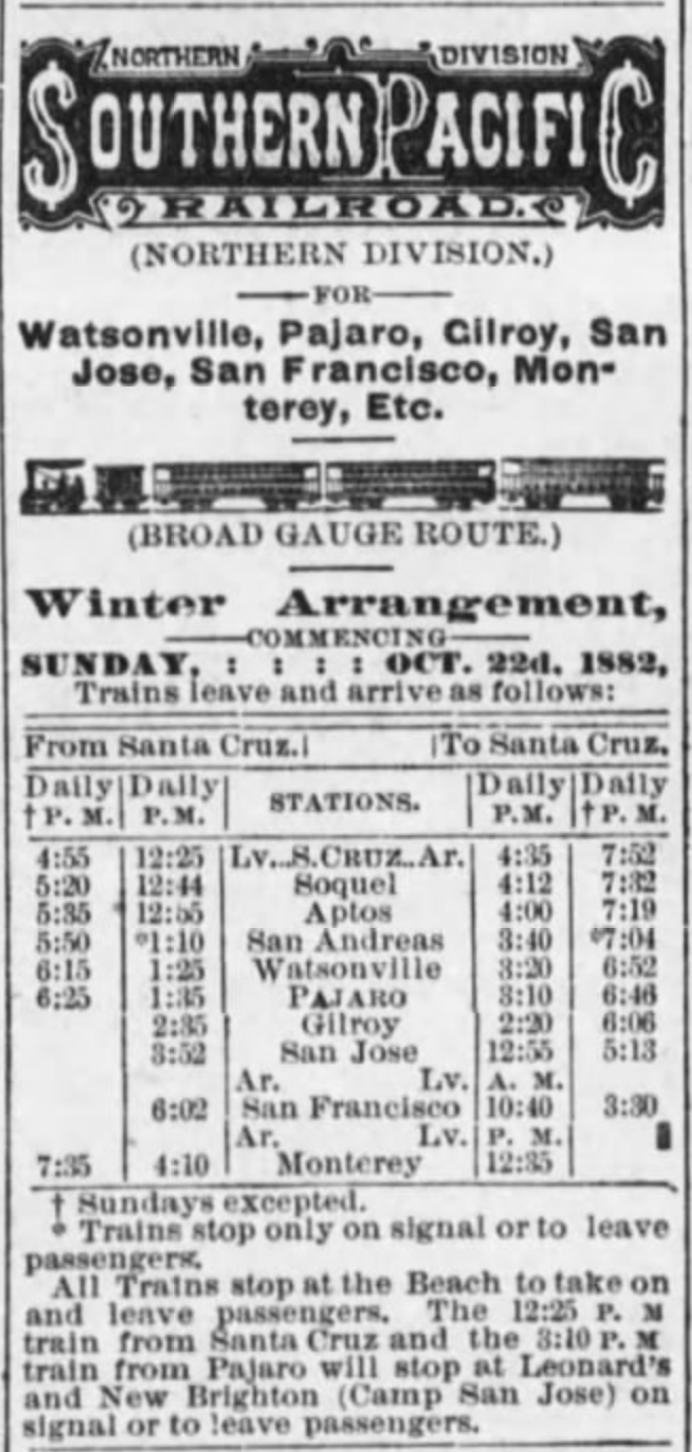
Southern Pacific Railroad schedule published in the Santa Cruz Sentinel, February 10, 1883.

San Francisco to Santa Cruz via Pajaro

The Santa Cruz Railroad was the first system in the county with the ability to connect to the Southern Pacific Railroad's Coast Division mainline at Pajaro, later Watsonville Junction. Once Southern Pacific took over and upgraded the line, a fluid exchange could happen linking Santa Cruz directly to San Francisco, although in reality there was rarely a through line between the points. Most of the time, passengers had to detrain at Pajaro and board a local train.

Passenger travel between Santa Cruz and San Francisco via the Coast Division mainline was never fast. In 1882, travel between the points—a distance of 121 miles—took around 5 hours, 10 minutes. This meant that the average speed of a journey to san Francisco was 23.4 mph. Around 1890, an express option was added that took just over 4 hours, which averaged 30.1 mph.  Over the next twenty years, the time was cut down further, eventually reaching 3 hours, 35 minutes in 1913. That brought the average speed up to 33.8 mph. From there, though, times increased again since all through traffic to San Francisco was directed north along the former South Pacific Coast route and then via the Los Altos Branch, popularly called the Mayfield Cutoff. By the end of passenger service along the Santa Cruz Branch in 1938, travel time from Santa Cruz to San Francisco via Watsonville Junction was 4 hours, 11 minutes, averaging a speed of 28.9 mph. Sun Tan Specials running from 1940 used this line to bring people to the Santa Cruz Beach and its travel time was 3 hours, 30 minutes, essentially the same as the regular passenger trains of the early 1910s.

Santa Cruz & Felton Railroad Time Table No. 2, from the Sentinel, February 10, 1877.

Santa Cruz & Felton Railroad

In some ways, the Santa Cruz & Felton Railroad was the shortest-lived of all the railroads in the county since it was wholly absorbed into the South Pacific Coast Railroad's mainline system in May 1880. It also did not formally engage in passenger service until several months after it began freight service in late 1875. But during the four years that it operated as a passenger railroad, it had a set scheduled that appeared in the local newspapers. Its No. 2 timetable, published in February 1877, gave travel time between Santa Cruz—then located at the Railroad Wharf—and Felton—near the Mountain Community Resources—as 1 hour exactly. This means that the 7-mile-long route transported passengers at a speed of...7 miles per hour. The Santa Cruz & Felton Railroad offered three runs in each direction. Later in the year, this was reduced to two runs, and in mid-1878 only one run each direction. This remained the status until the South Pacific Coast took over.

Cover of South Pacific Coast Railroad time table no. 3, March 28, 1886.

South Pacific Coast Railroad and Railway

The opening of the South Pacific Coast Railroad to Santa Cruz in 1880 heralded the first (nearly) seamless direct service between San Francisco and Santa Cruz. Nearly because a ferry was still required to transfer passengers from San Francisco to the Alameda Mole near Oakland. The South Pacific Coast was a narrow-gauge railroad that ran directly through the Santa Cruz Mountains, passing through Fremont, San José, Los Gatos, and eight tunnels before reaching the seaside town. Little changed along the line even after Southern Pacific acquired it in 1887, by which point it had reincorporated as the South Pacific Coast Railway. The entire line was not standard-gauged until spring 1909, after which most Santa Cruz–San Francisco traffic went via the Mayfield Cutoff rather than by the original Alameda route.

In the nearly thirty years from 1880, travel times between Alameda Junction and Santa Cruz remained remarkably stable. The speed of the train was always fastest between Alameda and Los Gatos, after which trains encountered a meandering track of steeper grades and sharper curves. Nonetheless, the route as a whole made good time. The April 4, 1881 timetable gave the travel time as 3 hours, 37 minutes, which resulted in an average speed of 20.8 miles per hour across 75.3 miles of trackage. Two years later, the time was reduced to 3 hours, 19 minutes leading to an uptick in the average speed to 23 mph. The timetables soon stabilized for the next decade at the slightly faster time 3 hours, 22 minutes, with trains travelling at an average speed of 22.4 mph. Perhaps due to safety concerns or constant repairs along the line, Southern Pacific eventually moved the time up around 1894 to 3 hours, 30 minutes, averaging 21.5 mph, which it retained until the 1906 San Francisco Earthquake shut down the line and it was standard-gauged.

Passengers boarding a South Pacific Coast Railway train at Ben Lomond, ca 1907. [UCSC Digital Collections – colorized using DeOldify]

Felton & Pescadero Railroad and Boulder Creek Branch

Travel time on the 7.30-mile-long Felton & Pescadero Railroad, a subsidiary of the South Pacific Coast Railroad, varied depending on which direction the train was travelling between Felton and Boulder Creek. If the train was heading north, it took 45 minutes to reach Boulder Creek. If it was heading south, possibly because trains needed to use their brakes more, it took 50 minutes to reach Felton. This meant that trains were travelling 9.7 and 8.8 miles per hour respectively. When Southern Pacific took over the line in 1887, it managed to cut the average travel time down to 33 minutes, which more or less remained standard for the next twenty years. Trains, therefore, could transport passengers between the two termini at a speed of 13.3 mph.

In 1908, when the line shifted to standard gauge, trains were finally able to run at a faster clip. For the first year, trains transported passengers between Felton and Boulder Creek in only 22 minutes! This meant the trains were running at an average speed of 19.9 mph. Clearly this was deemed unsafe, or perhaps the company changed to less efficient locomotives, since in 1909 the time was moved back to 30 minutes. Over two decades, the speed bounced between 25 and 30 minutes for the remainder of its time as a passenger line, which ceased around May 1931. Taking an average travel time of 27.5 minutes, the trains during the final years of the Boulder Creek Branch ran at a speed of 15.9 mph.

Ocean Shore Railway timetable no. 19, July 16, 1911.

Davenport-bound Railroads

Two railroads traversed the northern marine terraces of Santa Cruz County: the Ocean Shore Railway, later Railroad, and the Coast Line Railroad, a subsidiary of Southern Pacific. Both standard-gauge railroads were built at about the same time—between 1905 and 1907—and both had the stated, though unrealized, goal of linking Santa Cruz to San Francisco via a coastal route. The Ocean Shore did make it as far north as Swanton, 15.5 miles from Santa Cruz, but the most important destination along the line was Davenport, at least in the earlier years. This location was 10.8 miles from Santa Cruz on the Ocean Shore Railway, and 11.4 miles on the Coast Line Railroad.

The Ocean Shore's short, fourteen-year existence running passengers along the coast was a relatively consistent affair. All of the company's regular trains were mixed and trains took 28 minutes to run between Santa Cruz and Davenport. This resulted in an average speed of 23.1 miles per hour. The Coast Line, in contrast, began running incredibly slow trains. Initially, mixed trains took up to 1 hour, 15 minutes to transport passengers from Santa Cruz to Davenport, probably due to the number of freight stops trains along the way. So much time resulted in a dismal 9.1 mph speed. This soon picked up, though, and Southern Pacific managed to cut the time to 1 hour in late 1909, allowing trains to run at 11.4 miles per hour. By 1913, enough passenger traffic had picked up that dedicated passenger trains could operate, and these only took 30 minutes, matching the Ocean Shore's travel time and running at a far more comfortable speed of 22.8 mph. Both railroads retained this time for passenger trains until each ceased regular passenger service, in 1920 for the Ocean Shore, and in 1932 for Southern Pacific.

Southern Pacific's morning Santa Cruz express train arriving at San Francisco, August 19, 1937. Photo by Wilbur C. Whittaker [Jim Vail – colorized using DeOldify]

The Mayfield Route

The most efficient service that ever ran between Santa Cruz and San Francisco was the direct trains that Southern Pacific ran along the Los Altos Branch, commonly called the Mayfield Cutoff. What it "cut off" was San José, saving trains a major bottleneck of a station and saving several miles of track miles travelled. The Los Altos Branch, between Vasona Junction and Mayfield near Palo Alto, opened in 1908 and allowed through service from Santa Cruz beginning in mid-1909. The route proved so efficient that the mile markers along the Santa Cruz Branch were actually reversed so that they oriented north through the mountains rather than south toward Pajaro. By 1909, the latter route had been reduced to 120.5 miles between San Francisco and Santa Cruz, while the new Mayfield route was a trifling 79.2 miles.

In the early years of the Mayfield route, trains running between the two termini took 3 hours, 20 minutes to reach their destination. That meant they ran at an impressive average speed of 23.8 miles per hour. As with the South Pacific Coast Railway before it, the speed would have been considerably faster north of Los Gatos and slower through the mountains. In the early 1920s, Southern Pacific managed to shave off nearly half an hour from travel, reducing the time to 2 hours, 52 minutes, resulting in trains running at 27.6 mph. Over the subsequent twenty years, this time only got faster. By February 1940, just prior to the sudden shutdown of the route, regular trains travelling on the Mayfield route could reach San Francisco from Santa Cruz in only 3 hours, 9 minutes at a speed of 26.0 mph. But more incredible was the travel time of express trains, which could make the morning commute in 2 hours, 38 minutes at the then-incredible speed of 30.1 mph.

This was the end of regular or express commuter service in the Santa Cruz Mountains. Except for the occasional excursion train and the seasonal Sun Tan Specials, locals who wished to travel anywhere by train first had to drive or take a bus to Watsonville Junction, Los Gatos, or San José. An era of efficient, comparatively rapid transport had ended.

Citations & Credits:

  • Nanney, Duncan. Personal correspondence.
  • Santa Cruz Sentinel. Various articles, 1875-1940.
  • Southern Pacific Railroad Company, various records. California State Railroad Museum.

Thursday, August 12, 2021

Curiosities: The Ocean Shore Railway's 26-Mile Gap

The Ocean Shore Railway—a project over thirty years in the making—began with a bang and then died a slow and painful death as natural disasters, financial crises, bankruptcy, and mismanagement doomed the most optimistic railroad in the history of the Central Coast of California. On top of all the drama and failure, though, the most remarkably fact about the Ocean Shore Railway is how close it came to succeeding in a task that had dogged so many companies before it. The Ocean Shore's story is truly that of the Little Engine That Could, pushing on despite everything to finish its visionary route from San Francisco to Santa Cruz along the windswept margins of San Mateo County's foggy coastline.

An Ocean Shore Railway construction train atop a bridge near Davenport, 1907. [Western Railroader – Colorized using DeOldify]

Of course, the Ocean Shore Railway had not intended to fail. Indeed, right up until its declaration of bankruptcy in 1911, the company was working feverishly to achieve its primary goal. The Ocean Shore Railway Company had been incorporated in May 1905 to build two parallel eighty-mile-long standard-gauge electric railroad tracks down the coastline from San Francisco to Santa Cruz, where it would have linked up with other subsidiary networks and ultimately meet the Atlantic & Pacific Railroad at the Nevada state line. A branch line was planned for the hills above Pescadero with a possible extension to Big Basin and Boulder Creek. Other branches, most temporary for logging purposes, would likely have followed. Several town development projects were planned along the coast, most notably at Montara and El Granada north of Half Moon Bay.

An Ocean Shore construction train pouring fill below the bridge over San Vicente Creek south of Davenport, 1907. [Uncertain provenance – Colorized using DeOldify]

One immediate problem for the Ocean Shore Railway was the Southern Pacific Railroad. The Octopus controlled most land transportation on the West Coast and was not going to let an upstart railroad get in its way. Indeed, Southern Pacific preempted the Ocean Shore's incorporation by a month when it established its own Coast Line Railroad in April 1905 with almost identical goals as its rival, sans double tracks and electrification. Yet the Ocean Shore knew that Southern Pacific only really wanted the lucrative cement plant contract in Davenport, while the Ocean Shore hoped that the timber in the Pescadero and Butano basins would more than justify the loss of the plant's patronage. Nonetheless, Southern Pacific was certainly duplicitous in some of its dealings with the Ocean Shore Railway.

Ocean Shore Railway's depot in Santa Cruz overlooking the Southern Pacific yard, 1907. [Louis L. Stein, Jr. – Colorized using DeOldify]

In Santa Cruz, Southern Pacific leased land from the Cowell Lime Company at the beach and built a short spur for loading lime, conveniently blocking the Ocean Shore's access to land it had purchased to erect a deep-water pier. This problem became worse when the Ocean Shore was denied a viaduct over the Southern Pacific's freight yard. This viaduct was essential for accessing the company's proposed central depot in downtown Santa Cruz. Together, these two actions effectively stranded the Ocean Shore in West Santa Cruz with no outlet south, thereby imperilling its plans for a route across the county and beyond.

Meanwhile, the two railroads actually hired the same contractor to build both of its tracks north. Since the Ocean Shore had more ready cash and planned to build a double track, one of its tracks was built first. This benefited the Ocean Shore immensely in 1906. The earthquake delayed construction of a second track (Southern Pacific's) by a year, meaning that the Ocean Shore was able to profit off the cement plant's initial output during that time. However, once Southern Pacific did reach Davenport in 1907, it conveniently installed its wye in such a way to deny the Ocean Shore any further access to the cement plant. Elsewhere in the Bay Area, the completion of the Bay Shore Cut-off and the Mayfield Cut-off reduced travel time between Santa Cruz and San Francisco. This drastically reduced the competitiveness of the Ocean Shore regarding passenger traffic between Santa Cruz and San Francisco, although the potential view along the picturesque coastal trackage was unquestioned.

Work crews in the process of filling the tall trestle bridge over Panther Beach beside the Yellowbank Dairy, with the Coast Road visible through the bridge, 1906. [Covello and Covello – Colorized using DeOldify]

Construction of the Ocean Shore in Santa Cruz County began in mid-1905 and continued apace through to the earthquake on April 18, 1906. Although constructed using the same contractors as the Coast Line Railway, the Coast Line was running behind schedule so the Ocean Shore's initial single track was built to Davenport first. In February 1906, the Ocean Shore leased the Union Traction Company in order to extend its network further south to Watsonville—the anticipated next step in its scheme to build the line to Nevada. Beyond Davenport, grading crews made it to Scott Creek where they built a wye beside a small resort area the company hoped to develop called Folger, named after the coffee magnate. Freight traffic to Davenport began in late January 1906 and, following short delays from the earthquake, regular passenger service to Davenport began on June 15. Meanwhile, the track to Scott Creek was completed by October, several months behind schedule, but still not too far above upper estimates.

The long, partially filled trestle bridge across San Vicente Creek and Davenport Beach, 1906. [Gary Griggs – Colorized using DeOldify]

Along the route south of San Francisco, progress was moving more slowly. Track layers had only reached Mussel Rock outside Daly City by the time of the earthquake, but grading had been completed for many miles further south, with much of the equipment located on Devil's Slide, which was the most precarious part of the route. This proved disastrous when the earthquake struck, since much of that machinery was either buried or tossed into the sea. While railroad crews in San Francisco used its rolling stock to help remove debris following the quake and fires, the construction crews further to the south had weeks of work ahead of them recovering machinery, restoring rights-of-way, and reinforcing hillsides against further slides.  It was several months before actual progress resumed on the Northern Division, but work did slowly resume. Regular passenger service only began in October 1907 to Tobin (Pedro Valley).

The Ocean Shore Railway's Pedro Point Tunnel north of Devil's Slide following abandonment of the line, 1928. [Uncertain provenance – Colorized using DeOldify]

Unfortunately for the Ocean Shore Railway, many of its wealthier financiers pulled out of the company in the months following the earthquake. A few were ruined by the earthquake, but others just decided to be more cautious with their money. The resort at Folger was probably one of the casualties of this restructure even though construction on the Southern Division continued without more than a hitch. The railroad found more investors and scraped together enough funds to continue building through the rest of 1906 and into early 1907. Construction to Half Moon Bay resumed after the Devil's Slide mess was cleared. Meanwhile, a new contract was made with Shattuck and Desmond to continue building the line from Scott Creek to Pescadero. In June 1908, the subsidiary Scott Creek Railway was incorporated to extend a track up Scott Creek and Little Creek to the timber tracts of the San Vicente Lumber Company. This proved to be the Southern Division's most profitable and reliable customer throughout the 1910s.

Advertisement for the San Juan Pacific Railway, 1907. [Unknown provenance]

Optimism was always the Ocean Shore Railway's greatest strength and weakness. The earthquake led to the Ocean Shore abandoning its purchase agreement of the Union Traction Company, although it retained an option to purchase it at a later date. On December 28, 1906, the railroad incorporated its first subsidiary, the Monterey, Fresno & Eastern Railway, and soon afterwards this company leased the Watsonville Transportation Company in the hopes that it could extend the small interurban line to Hollister and Fresno. In February 1907, alongside the lease of the interurban, Ocean Shore incorporated another subsidiary, the Ocean Shore & Eastern Railway, which was intended to build a railroad line from Santa Cruz to Watsonville, likely using the Union Traction line, although it did not resume its deferred payments at this time. In April 1907, the San Joaquin Valley Western Railroad was founded to connect Watsonville to Fresno, and in May the San Juan Pacific Railway was incorporated to link Chittenden to San Juan Bautista and its new cement plant, with plans to eventually extend its line further south through the Gabilan Range. All but the last of these projects came to nothing.

Ocean Shore Railway train on a high fill across a beach near Davenport, ca 1908 [Western Railroader – Colorized using DeOldify]

The nail in the coffin of the Ocean Shore Railway proved to be neither Southern Pacific interference nor the 1906 earthquake. Instead, it was the Knickerbocker Crisis which led to the Panic of 1907. A stagnant economy following the earthquake had led to a recession and by October 1907, the New York Stock Exchange was half the value it had been the previous year. The actual panic occurred when several banks, most notably the Knickerbocker Trust Company, failed to seize control of the United Copper Company. The collapse of Knickerbocker led to a run on money and the withdrawal by many from high-risk investments. Although the crisis was short-lived, it led to many of the remaining and new investors in the Ocean Shore Railway to pull out. Funds were solicited locally in early 1908, allowing construction to continue, but the railroad was running entirely on rapidly-increasing debt.

Idealized postcard of Granada Depot on the Ocean Shore line, 1908. Image produced by Charles H. Kendrick Company. [Cambridge Lutece – Colorized by DeOldify]

Despite everything, optimism remained through 1908. Property along the San Mateo County coast was selling quickly, while farmers, quarriers, and lumber companies were eager to begin shipping via the completed railroad. Construction on the Southern Division was primarily focused on the Scott Creek Railway line rather than the route north, although surveyors were likely busy determining the best means of crossing Scott Creek. In the north, passenger and freight service to Granada opened in June 1908 and Half Moon Bay in October, while tracks were laid across the Tunitas Creek bridge by January 1909. Another bridge was built a mile south over Palmer Gulch (Trestle Beach), but no tracks were ever installed here. Grading, meanwhile, had progressed as far as Pigeon Point. At Pomponio Beach, two short tunnels were in the process of being bored when construction ceased on the line.

Ocean Shore Railway auditor Ted F. Wurm on right with family members standing on the tracks near Davenport, ca 1910. [Marvin T. Maynard – Colorized using DeOldify]

The end result of the Ocean Shore Railway's three and a half years of effort was approximately 54 miles built of an 80-mile-long railroad. The missing section, 26 miles between the southern bank of Tunitas Creek to the southern bank of Scott Creek, was never completed. However, grading south from Tunitas, including a bridge and two tunnels, was partially completed for around 12.5 miles to Pigeon Point, and possibly even further to the south, meaning that only 13.5 miles remained of heavy work on the line. Some of this may have been damaged in the heavy winter storm of 1909 that wrecked large portions of the right-of-way, effectively shutting it down until late April. This storm mixed with creditors finally calling in their debt put an end to the reckless optimism that had been motivating the company previously. The company was $2,321,740 in debt and had nowhere left to turn for help.

The Ocean Shore Railroad beside Islais Creek and Mission Street outside San Francisco, 1915. [OpenSFHistory]

The Ocean Shore Railway went bankrupt on December 6, 1909 and was reincorporated as the Ocean Shore Railroad on October 9, 1911, following nearly two years in receivership. Although the new firm stated its intention to fill the 26-mile gap between Tunitas Creek and Scott Creek, it never had the funds to do so. Estimates in 1911 placed the cost of finishing the line at $1,351,115, over $35,000,000 in 2021 money. Thus, the new company, sans the debts of its predecessor, never bothered to finish the final 26 miles of its route, which was the only way the railroad would survive in the long term. Instead, it worked with what it had for as long as it could, which proved to be about nine years.

An accident at Little Creek switch outside Swanton, 1916. [UCSC Legacy Digital Collections – Colorized using DeOldify]

Possibly as early as 1908, regular horse-drawn stage coach service connected Davenport or Swanton in the south with Tunitas or Half Moon Bay in the north. The details of this early connecting activity are obscure, although it is known that the Ocean Shore Railway funded the service in order to maintain the premise of their coastal railroad. However, it was slow, poorly patronized, and couldn't compete once automobiles began appearing on the coast in the early 1910s. A solution had to be found and the new Ocean Shore Railroad had an idea.

An Ocean Shore Auto Stage Stanley Steamer leaving Tunitas for Santa Cruz, ca 1914. [Uncertain provenance]

Rather than providing rather typical coach service between the railroad's two termini, it purchased a Stanley Motor Carriage Company autobus to bridge the 26-mile gap via a new subsidiary, the Ocean Shore Auto Stage Company, incorporated in March 1914. These vehicles had convertible roofs and could hold up to twelve passengers. They were operated by a thirty horsepower steam engine designed in a novel and space-saving manner, although they were known for burning through water quickly. Due to the initial popularity of the service, a second Stanley Steamer was added to the roster on June 10.

Both Ocean Shore Auto Stage Stanley Steamers in Pescadero, 1914. [Bob Gray]

Service between Tunitas and Swanton began on April 1, 1914 under the direction of James W. Gray, a former Ocean Shore brakeman. The second steamer was operated by Harry L. Staples. Through service from San Francisco to Santa Cruz via rail and steamer cost $4.50 a ticket and took a total of 8:15 hours northbound and 7:50 hours southbound. The Stanley Steamers called in at Waddell Creek, Gazos Creek, Pigeon Point, Pebble Beach, Pescadero, San Gregorio, Tunitas Glen, and Torquay, providing transportation to and from some of the most remote communities on the Central Coast. A separate bus service also transported people from Torquay to the California Redwood Park (Big Basin). During wet winters, when portions of the railroad's right-of-way were washed out or otherwise damaged, the steamers also provided service shuttling passengers around inoperable sections.

The never-used Palmer Gulch bridge, 1920s, already showing a distinct slump in the center. [UCSC Legacy Digital Collections – Colorized using DeOldify]

Most Ocean Shore Railroad services ceased on August 17, 1920. The Southern Division was subsequently leased to the San Vicente Lumber Company while the Northern Division was scrapped. Remnants of the right-of-way survive all along the coast, especially in San Mateo County. Between Tunitas Creek and Scott Creek, some cuts and fills can be found beside Highway 1, but much more was once visible. The bridges over Tunitas Creek and Palmer Gulch remained for many decades until they either collapsed or were demolished. The two incomplete short tunnels at Pomponio Beach existed into the 1970s before they collapsed or were demolished for safety reasons.  Another tunnel south of Pescadero Beach appears on the 1961 USGS quadrangle map but has also now disappeared. 

A Stanley Steamer somewhere along the 27-mile gap with its roof up, ca 1918. [Randolph Brandt]

Meanwhile, the autobuses of the Ocean Shore Auto Stage Company continued to operate across the entire line under emergency provisions. On January 14, 1921, Gray and Staples were granted a permanent franchise to continue running buses between San Francisco and Pescadero, which led to the incorporation of the Coastside Transportation Company later that year. Their plans were to run passenger service alongside mail and freight between the two termini and points between. The Railroad Commission, however, limited the franchise repeatedly, forcing Gray to redirect traffic to Colma and San Mateo, drastically reducing his potential profits. He became frustrated and looked for interested buyers of his franchise.

Coastside Transport Company advertisement from the Santa Cruz Evening News, March 15, 1940.

On July 16, Gray sold the company to Edward Serretto, Louis Alfred Mattei, and Emile Michel. In 1925, the company under William Azevedo petitioned to run freight between San Francisco and Half Moon Bay but was again denied by the Commission. The firm's persistence finally paid off in March 1927 when it received permission to run passenger, freight, and express service across the entirety of the old Ocean Shore route including all settlements along the way. Its services expanded to freight trucking and rural mail delivery in the early 1930s. The firm declared bankruptcy in late 1933 only to reform with the same franchise rights as the Coastside Transport Company in November of that year. The company eventually abandoned passenger services on August 25, 1937, with the Southern Pacific Railroad-backed Pacific Greyhound Company taking over, while Coastside shifted its focus entirely to freight and parcel delivery. Coastside survived for another five years before selling out to Highway Transport Company on August 4, 1942.

Citations & Credits: