Showing posts with label San Juan Pacific. Show all posts

Friday, August 12, 2016

Stations: San Juan Junction

The end of the line for both the San Juan Pacific Railway and the California Central Railroad was at San Juan Junction, 7.8 miles south of the Southern Pacific Railroad track at Chittenden. San Juan Junction was a rather fanciful name that referred to the junction with the narrow-gauged San Juan Southern Railway, which was supposed to travel an additional thirteen miles down San Juan Canyon but, due to economic problems, only ran three miles and never was used. The California Central kept the name, however, because they did succeed in building and using four miles of that line narrow-gauged line, continuing construction of it all the way to 1929, the last full year the railroad operated. But there was no transfer yard at San Juan Junction. Instead, there was a moderately-sized Portland cement plant installed at the site.

Unassembled parts stored at the San Juan Portland Cement site awaiting construction, 1908.
Construction on the San Juan Portland Cement Company refinery and kilns began in August 1907, immediately after the San Juan Pacific was opened for through traffic. Within days of completion of the railroad, carloads of machinery for the refinery were brought in and dumped beside the tracks at San Juan Junction. The track was extended an additional 0.3 miles to a gravel site south of the Junction and the material there was used for ballast along the line. At the Junction, a parallel spur was installed opposite the cement plant so that, when the plant was built, it would be straddled by tracks on either side for maximum efficiency. By September, all the machinery was in place, but nothing had been installed yet. Work had already begun on the San Juan Southern Railway right-of-way, with three miles of track placed by October. And then panic struck the stock market and all work on the cement plant and the railroad was halted. Unfortunately, most of the company's stock value plummeted since it was bound to the Ocean Shore Railroad scheme and the San Juan Pacific began its free-fall. The San Juan Portland Cement Company went bust before it had even warmed up the kilns.


Old Mission Portland Cement Company corporate logo.
In January 1912, the Old Mission Portland Cement Company took over operations of both the refinery and the railroad, the latter being rebranded the California Central. For five years, the Old Mission Route was rebuilt with higher-quality materials. Meanwhile, loads of new construction equipment was shipped to San Juan Junction so that the new company could build the long-awaited refinery. San Juan Junction became a true junction at this point. The single standard-gauge locomotive shared space with the company's narrow-gauged unit in the engine house, and the same crews operated and maintained both locomotives on the site. The cement plant thrived for much of the period from 1918 to 1929. In 1927, the organization was merged with the Pacific Portland Cement Company. But the Great Depression made quick work of the entire operation. Broke and without customers, the cement plant and the railroad closed shop. The refinery was gated and abandoned, its pair of locomotives – one narrow-gauged, one standard – left to rot in the engine house. In 1937, the standard-gauged engine had one last run on the old, weed-infested line, but that was simply to ship it out of the county where it operated in Gerlach, Nevada, for its owner, the Pacific Portland Cement Company. The tracks were pulled in early 1938 and San Juan Junction became little more than a dream of a bygone era.

Add caption
The cement plant had a second life, however. Reopened in 1941 due to war demands, the renewed cement plant continued to operate using trucks into the 1970s. It finally closed because the owners were unable to meet new California state air pollution control requirements. The site was eventually stripped of all of its machinery and has since returned to its original owners who use it as a cattle pasture.

Official Railroad Information:
San Juan Junction was at mile marker 0.0 on the San Juan Pacific Railway line. As with the rest of the route, passenger service was offered at the station three times daily for the first year that it operated, after which all passenger service ceased. All service stopped by June 1909.

Limited freight service for the purpose of building the refinery resumed to San Juan Junction around 1914, and then formally reopened in 1916. From this point, irregular freight service from San Juan Junction continued until the refinery closed in 1930. The engine house (and presumably a turntable) was maintained at San Juan Junction until the tracks were pulled in early 1938.

Geo-Coordinates & Access Rights:
36.831˚N, 121.531˚W

Last remaining tracks of the California Central, embedded
into San Juan Canyon Road at The Alameda.
[GeologyCafe.com]
The site of San Juan Junction and the cement plant are unfortunately not accessible to the public. Heading southbound on The Alameda out of San Juan Bautista, continue on San Juan Canyon Road (G1). At that intersection, tracks are still imbedded in the center of the road, the last vestige of the original San Juan Pacific and California Central tracks, which was not removed for convenience's sake. For the next 0.4 miles, the old right-of-way is on the west side of the road in what is now reclaimed pastureland. As the road turns slightly to the east, the road to the cement plant and San Juan Junction appears. The site of the old depot is now a paddock of some kind immediately beside the road, leaving little evidence of the original structure behind. The cement plant itself is barricaded and the land is used for grazing cattle. Google Maps shows that the site of the cement plant remains visible, albeit heavily overgrown. The old narrow-gauge right-of-way continues to the south out of the facility.

Citations & Credits:
  • Clough, Charles W., and Bobbye Sisk Temple. San Juan Bautista: The Town, the Mission & the Park. Quill Driver Books, 1996.
  • Hamman, Rick. California Central Coast Railways. Santa Cruz, CA: Otter B Books, 2002.
  • Perazzo, Peggy B. "Stone Quarries and Beyond". Pre-captioned images above.
  • Robertson, Donald B. Encyclopedia of Western Railroad History, vol. 4: California. Caxton Press, 1986

Friday, August 5, 2016

Stations: San Juan

Three decades after the Spanish friars of the Franciscan Order had founded their first mission in the Alta California region of Nuevo España, they decided that a small outpost tucked away in a sparsely-inhabited tributary valley of the Pajaro River would serve as an excellent waypoint for pilgrims, soldiers, and missionaries traveling up and down the King's Highway – El Camino Real. In November 1795, a small group of explorers and friars spiked a cross on a site at the mouth of a deep valley and proclaimed the place San Juan Bautista after Saint John the Baptist. It took two years for a physical church to be completed at the site, with it officially dedicated on 24 June 1797. In 1803, construction began on the current adobé and redwood structure, and it was completed in 1812 becoming the largest of all twenty-one missions in the Spanish system. The mission largely prospered on its bluff that overlooked the floodplains of the San Juan Valley. Many supporting structures were built around the core mission complex, while farmers and ranchers from various backgrounds settled in the surrounding region to work for the Franciscans. Although the mission suffered during the Mexican Revolution and its aftermath, the church continued to operate without a break.

Drawing of Mission San Juan Bautista, c. 1830. [California Missions Resource Center]
The secularization of Catholic Church lands in 1834 greatly reduced the scope of the mission, but locals continued to patronize the church each week and it never closed as so many other missions did. When the United States took control of California and gold was discovered soon after in the foothills of the Sierra Nevada, the tiny hamlet of San Juan Bautista quickly grew. Prospectors travelling between Monterey and the interior passed through the town, with many settling after striking rich and others never leaving, opening businesses to sell wares to the passersby. The village became a mid-sized town with multi-story buildings in the main plaza, general stores, hotels, restaurants, and feed stores. A fire destroyed much of the town not long afterwards, depriving it of some of its glory, but it was the railroad that really turned the tide against San Juan.

The Plaza Hotel across from the mission, 1893. [fine art america]
In 1870, the Southern Pacific Railroad reached Hollister, a town just a few hours' wagon ride away from San Juan Bautista. With the end of prospectors, the relatively recent fire, and a lack of available land in the valley, many shifted their attention away to this new site, hoping to capitalize on the railroad which still intended at this time to continue south into the San Joaquin Valley. The town never died, but it barely grew after this point and in many ways never recovered from the fire and loss of the railroad.

San Juan Station, late 1908, with a passenger train sitting out front. [McMahon & Hendershot]
1915 USGS map showing the town of San Juan Bautista, although notably
no railroad station appears at the junction of the road to Hollister (bottom).
In 1907, the town's prospects rose again. The Southern Pacific Railroad had been considering a route between their station at Betabel and San Juan Canyon for nearly thirty years as a short-cut to the San Joaquin Valley. Other rivals had also partially surveyed routes in the area in half-hearted attempt to defeat the Southern Pacific transcontinental monopoly. The plans of the San Juan Pacific Railway were no different: they wished to connect to the Ocean Shore Railroad and other proposed lines in a trans-California route that would one day span the nation. But in the meantime, the San Juan Portland Cement Company wished to open a refinery in the hills just outside of town. They fronted the cash to form the railroad in order to expedite the construction and shipment of goods. The new route would loop around the eastern side of the town with a station established along the main road to Hollister just below the mission. Around August 1st, the track to San Juan Bautista was completed and a long siding was installed to cater to local businesses such as the Loma Prieta Lumber Company, which intended to build a yard beside the tracks and harvest nearby forests. The route formally opened on October 1, 1907, and San Juan Bautista had its very own railroad at last.

Mission San Juan Bautista at the time the San Juan Pacific Railway first came to town.
Passenger train returning from Chittenden, c. 1907.
[McMahon & Hendershot]
Presumably, a railroad structure was built to cater to passengers awaiting the three passenger trains that ran daily in either direction between San Juan and Chittenden. However, the financial difficulties that quickly consumed both the cement plant and the railroad may have halted any permanent structure since no known photograph exists of such a depot or shelter. By May 1909, San Juan Station was a lost dream. The railroad went bust. When the California Central began running regular freight runs along the Old Mission Route in 1916, service to the Loma Prieta yard continued, but for how long is unknown. Most trains headed without stopping for the cement plant and any passengers would have to find other means of getting to the nearest Southern Pacific station. It is unknown how long trains serviced the Loma Prieta yard, but general freight service past San Juan continued through 1930, after which the tracks lay dormant until they were pulled in early 1938. The mission continues to look out over the San Juan River floodplain, but nothing remains of the station, tracks, or right-of-way that sat so briefly in its shadow.

Official Railroad Information:
San Juan appeared on the first public timetables for the San Juan Pacific from mid-1907 through May 1909 as 1.3 miles from San Juan Junction and 8.7 miles from Chittenden (although, in reality, it was closer to 6.4 miles from the latter). It was listed as having three passenger trains in each direction daily. Records for the California Central Railroad are more difficult to find but there was no known service to the former stop after 1909.

Geo-Coordinates & Access Rights:
36.841˚N, 121.532˚W

The precise site of San Juan Station is not entirely certain but it was most likely on either side of modern-day State Route 156 near Nyland Drive or Groscup Way. If it was on the north side, it occupied the same location of today's San Juan School. If the south side, it sat in the open lot between Groscup and the highway. The Loma Prieta Lumber Company lot was most likely the large grass field on the south side of the road east of Groscup. Most of this area can be explored to a degree without breaking any trespass laws, but nothing of the station or right-of-way survives in this immediate area.

Citations & Credits:
  • Clough, Charles W. San Juan Bautista: The Town, The Mission & The Park. Sanger, CA: Word Dancer Press, 1996.
  • Hamman, Rick. California Central Coast Railways. Santa Cruz, CA: Otter B Books, 2002.
  • McMahon, Joseph, Carla Hendershot, and the Plaza History Association. Images of America: San Juan Bautista. Charleston, SC: Arcadia Publishing, 2007.

Friday, July 29, 2016

Stations: Prescott & Beet Dump

The location of the Prescott family property along the right-of-way,
San Benito County map, 1891 [UC Santa Cruz Digital Collections]
Not long after California became a state, the Prescott family moved into the San Benito Valley on a small ranch within the former San Juan Bautista Mission rancho. William Sims Prescott Sr. was an English-born settler who journeyed to California to work in the lumber industry of the Santa Cruz Mountains and, later, in the New Idria Mines. Once in the state, he met Catherine Hobson, a Canadian woman, and the two of them settled down in the San Juan Valley, becoming locally famous for constructing the first artesian well in the region as well as the first orchards. They raised a son and a daughter, William Sims Jr. and Emma, on their ranch along the San Benito River in the late 1850s. Emma eventually married John C. Skinner and moved to San Francisco, where she died in 1922. William, meanwhile, became the family patriarch when his father died in 1878. William married Elizabeth Maria Prather of Tennessee in 1885 and together they raised four children on the ranch.

William quickly rose in prominence in the local community, especially once he was elected to the Board of Supervisors in 1902 for District 2 (San Juan Region). He kept this position into the 1930s. It was during the mid-1900s that plans were put in place to run the San Juan Pacific Railway between Chittenden and San Juan, a project that required Prescott's permission in order to begin. Unsurprisingly, when the San Juan Pacific began operations in 1907, a stop named "Prescott" appeared on public timetables at a location near the Prescott family property.

In reality, the location probably only ever served as a freight stop for the Prescott family and their neighbors. The farms in the region largely grew sugar beets for Claus Spreckels and other various vegetable products, which collectively justified a small freight stop in the area. As visible on the 1891 map above, a small T road intersection at the southwest corner of the Prescott property later coincided with the location of the railroad stop, meaning that local farms could use established roads to get their goods to market without having to drive into San Juan or up to Canfield or Chittenden. The railroad installed a 700-foot-long siding at the stop to park wagons for loading of sugar beets. Farmers, seeing the potential of the site, added a large beet-dumping platform there as well to expedite the process.

Although passenger service ceased in 1908, freight traffic continued intermittently all the way to 1930 when the California Central unofficially ceased operations. During the California Central period, Prescott was renamed "Beet Dump" but the purpose of the stop remained the same – local farmers could deliver their goods to the site for loading on passing freight trains. The name implied that sugar beets were the primary product with their destination doubtlessly the large beet refinery in Salinas. The tracks remained on the property until they were finally scrapped in early 1938.

Photograph of prominent San Juan citizens including, from left-to-right, William Prescott, Edward A. Pearce,
Luis Raggio, Ernest CC Zanetta, and George Abbe, c. late 1930s. [Marjorie Pierce]
William and Elizabeth Prescott lingered longer. William suffered a heart attack in 1943 just before his 58th wedding anniversary, but he survived two more years before passing away June 15, 1945. Elizabeth survived him by eight years, dying January 31, 1953. Both are buried at the San Juan Bautista Cemetery near the burial places of their mothers. Their property is entirely farmland today.

Official Railroad Information:
San Juan Pacific Railway timetables noted that Prescot was 2.3 miles from San Juan Junction and 1.0 miles from San Juan [Bautista]. This placed it 5.7 miles from Chittenden and the Southern Pacific mainline track. Few records exist from the California Central period but what does seem clear is the stop lost its name and simply became known as "Beet Dump", a reference to the old beet-loading platform constructed there around 1908.

Geo-Coordinates & Access Rights:
36.860˚N, 121.542˚W

The site of Prescott is one of the few locations along the San Juan Pacific right-of-way that can be guessed with almost complete certainty. The right-of-way crossed modern-day Prescott Road at the entrance to today's True Leaf Farms – Church Brothers Produce facility. This facility without doubt sits on the site of the original "Beet Dump", which was itself the successor to Prescott. In fact, a tiny grass-covered and undeveloped stretch of right-of-way still sits across the road from this facility and the driveway of the facility was once the right-of-way. Access to True Leaf Farms – Church Brothers Produce is restricted to employees. Nothing visible remains of the railroad in this area and trespassing should not be attempted.

Citations & Credits:

Friday, July 15, 2016

Stations: Canfield

Location of Canfield (bottom-right corner) in relation to Chittenden, 1891.
Survey map conducted by Vic. T. & Harry W. McCray.
[UCSC Digital Collections]
The San Juan Pacific Railway had few patrons along its eight-mile route. The purpose of the railroad was always first-and-foremost to cater to the San Juan Portland Cement Company, so all other customers were secondary to that goal. Nonetheless, the property of the Canfield family, located south of the bend of the route as it turned toward San Juan Bautista, was the railroad's first customer.

In February 1887, Samuel Russel and William Walton Canfield purchased from J.B. Doane a quarter section of ranch land in the Gabilan foothills region near the confluence of the San Benito River into the Pajaro River. Samuel and William were brothers, two sons of Robert Finley Canfield and Ruth Halsey Walton. William moved to California in 1849, presumably during the Gold Rush, and became a farmer. His brother joined him at some unknown later date. Very little is known about their cattle ranch or its success over the years. Both Canfields were active with the Central Coast Counties Improvement Association between 1903 and 1906, with Samuel serving as president in the first two years and William serving as vice president in the subsequent years. The organisation was one of a number that supported the expansion of railroading into the peripheries of the Central Coast, to places such as Davenport and San Juan. As such, it is unsurprising to discover in 1907 the route of the San Juan Pacific Railway skirting the north-east edge of the Canfield property as it worked its way south.

Canfield – the name appropriately given to the stop located on the Canfields' ranch – became the site of the first siding build along the San Juan Pacific line. The railroad built a 600-foot track there so the local ranchers and farmers could load hay and stock, and unload general merchandise for their small, rural businesses. Additionally, for the first year or so, Canfield served as an official stop for passenger trains, allowing an easy means for locals to travel to Santa Cruz, San José, or San Francisco for business or vacation. In that first years the stop was catered to three times a day in either direction. It is unknown how frequently the stop was used by passengers or freight customers.

The financial collapse in late 1907 spelled the eventual end of all services along the San Juan Pacific line, while damage from winter storms crippled it. When the route reopened in 1916 as the California Central Railroad, Canfield was not included on the roster. Although the tracks continued past the property until the final dismantling of the route in early 1938, the Canfields could no longer call on passing trains and, presumably, their siding was removed or left to decay.

The fate of the Canfield family is also not entirely known. Samuel married Alice Marion Butler in June 1903. Samuel and Alice moved to San Francisco later in life where he predeceased her. Alice lived until October 1972, dying at the age of 97.  William Canfield remained active in San Benito County to 1919, at least. He was responsible for a short-lived campground installed at Pinnacles National Monument. Nothing is known about his spouse or his date of death, but he did have at least one son who died in 1964. The Canfield brothers have no known relationship with the Canfields of the Santa Cruz Beach Boardwalk.

Official Railroad Information:
Canfield only appeared on official timetables in 1907 and 1908. On these tables, it was noted as 5.5 miles from San Juan Junction, the official end-of-track, which made it 4.5 miles from Chittenden. However, these very clean measurements were entirely off. In reality, Chittenden was only 2.3 miles away along the right-of-way, confirming that the length of the line was 8.0 miles, not the 10.0 the railroad advertised it as.

Geo-Coordinates & Access Rights:
36.875˚N, 121.554˚W

The site of Canfield can be found along the San Juan Highway directly across from its intersection with San Justo Road. The site itself is unmarked but the stop would have been located near the intersection of Anzar Road and San Justo Road. Indeed, everything along San Juan Highway on the west, from the south side of Anzar Road to the southern end of the Berkley Operations and Earthbound Farm complex (on the east side of the road) constituted the Canfield property. Their western boundary was the hillsides. Nothing remains of their ranch now except agricultural fields.

Citations & Credits:
  • Daily Independent Journal (San Rafael), 10/05/1972.
  • Hamman, Rick. California Central Coast Railways. Santa Cruz, CA: Otter B Books, 2002.
  • Hollister Free Lance, 02/18/1887.
  • Robertson, Donald B. Encyclopedia of Western Railroad History: Vol 4: California.  Caldwell, ID: Caxton Printers, 1998.
  • Santa Cruz Sentinel Evening Sentinel, 1903 – 1913.

Friday, July 8, 2016

Stations: Chittenden

In the remote fringe of Santa Cruz County, buttressed between high mountains and closer geographically to Santa Clara and San Benito counties as it is to Watsonville, the small community of Chittenden sits beside Soda Lake. Of all the railroad stops in the Santa Cruz County, this was the most isolated for it is the only stop of the mainline Coast Division of the Southern Pacific Railroad in Santa Cruz County. It also was the first stop in the county.

Map of Rancho Salsipuedes, 1853. (UCSC Special Collections)
Nathaniel W. Chittenden unintentionally leant his name to the station when he settled in what became known as Chittenden Pass around 1870. He had been until that time a lawyer from San Francisco. When he moved to Santa Cruz County, he purchased the eastern corner of Rancho Salsipuedes. The rancho had a long and disputed history, with its origins in a possible land grant to Mariano Castro in 1807, making it one of the few Spanish, rather than Mexican, land grants in the county. It was the second largest rancho in the county, as well, measuring 25,800 acres. Because of its large size and its disputed status, it was one of the first ranchos that was divided up following the American annexation of California. Its last Mexican owner was Manuel Jimeno Casarín. The soil of the rancho as a whole, but especially within the pass between the mountains, is highly fertile and the alkaline Soda Lake, the only such lake in the county, was a source for mineral collection. The road that passed through the pass became a county road in 1894 and it remains one of the primary means of passing between Santa Cruz and Santa Clara counties even today. Chittenden died in Watsonville in 1885, after which his lands were divided between his relatives. Idea H., Clara, and Talman Chittenden were his chief beneficiaries.

The Chittenden community center, showing a small general store, c. 1900. (Santa Cruz Public Libraries)
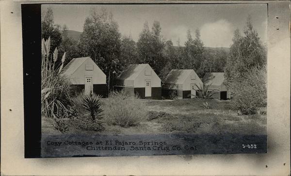
El Pajaro Springs postcard, c. 1910. (CardCow.com)
Chittenden as a settlement was never impressive—numbering fewer than 80 residents in 1893. The small community that lived in the gap still managed to establish a post office in April 1893 and kept it running for many years. The railroad station was probably established around the same time under the name "Chittenden's", later dropping the "s". In those early years, one of the primary draws of the region was Chittenden Springs, which was established beside a sulphur hot spring located in the gap. In 1906, the Chittendens sold the spring to A.F. Martel who renamed it El Pajaro Springs, a reference to the Pajaro River that still passes through the pass. In 1918, it was sold again to the St. Francis Hospital of San Francisco and it became St. Francis Springs. The resort was beside Soda Lake.

1906 San Francisco Earthquake damage at Chittenden.
(Granite Rock Company)
The railroad stop at Chittenden was primarily used for freight. Passengers could use the facility as a flag-stop, but no agency office was available there to purchase tickets. No passenger shelter appears to have been built initially. A siding (or pair of sidings) at Chittenden ran along the north side of the tracks, between where the tracks are today and State Route 129, branching off near the first major driveway over the tracks and merging just before where the highway crosses under the tracks. A spur may have run to Soda Lake as there is some topographical evidence of such. If so, this route would be identical to the dirt road that now leads to the lake. Mining operations in the hills continued into at least the 1910s and used the sidings to store waiting cars. In addition, there were vast clay deposits along the banks of the Pajaro River and along Pescadero Creek above Chittenden, which were mined as well. By the early 1900s, Granite Rock Company also used the sidings to store firewood-filled boxcars that were used in their kilns at Logan.

Chittenden's small post office building with a man posing out front, 1900. (Santa Cruz Public Libraries)
Boxcars damaged by the 1906 San Francisco Earthquake, at Chittenden.
(Granite Rock Company)
Around the time that Chittenden as a community was fading, the railroad operations out of the station received an unexpected boost. The San Francisco Earthquake of 1906 certainly helped in that it increased demand for all building supplies, such as the mineral, clay, and limestone deposits in and around the San Benito and San Juan valleys. For at least a year already, the Ocean Shore Electric Railroad was intending to pass through Chittenden Gap to connect to a proposed mainline route in the San Joaquin Valley. But a group of trigger-happy investors decided that a route to San Juan Bautista would help progress things a bit faster. When negotiations with the Southern Pacific Railroad failed, the group relocated their planned northern terminus from Betabel to Chittenden. The San Juan Pacific Railway was incorporated on May 4, 1907, and construction began almost at once out of Chittenden with the route completed August 30.

Initial plans were to build the railroad's right of way directly under the Southern Pacific tracks with a yard and station built on their northern side. But this goal was for another day. Initially, they crammed in a two-track yard on the south side, between the Southern Pacific tracks and the Pajaro River embankment. A small freight platform and passenger shelter were erected beside the tracks. The tracks were connected to a Southern Pacific siding on either side allowing entry and exit in either direction along the line. Curiously, the railroad had no wye at either end, suggesting there was possibly a turntable somewhere along the line (and potentially at both ends). No evidence for a turnable, however, has been found. The northern water towers were kept at Chittenden just before the Pajaro River bridge crossing to the east.

San Juan Pacific passenger shelter and freight platform at Chittenden, 1908. (Santa Cruz Public Libraries)
For the remainder of its life, Chittenden Station was more a transfer point between the San Juan Pacific (later California Central) and the Southern Pacific. Until early 1909, passengers transferred here for rides down to San Juan Bautista on the "Old Mission Route" and there was occasional bustle at the stop, but that all collapsed pretty quickly when financial difficulties ended passenger service permanently along the line. When the California Central took over in 1912, it did not resume passenger service. From 1916 to 1929, cars from the Old Mission Cement Company plant south of San Juan Bautista would transfer to passing Southern Pacific trains for delivery to various customers. Meanwhile, empties cars or cars with cement supplies would return to the sidings awaiting shuttling back to the plant. This was what kept Chittenden alive for so long. The town's post office had closed June 15, 1923, and the town had disappeared in the meantime. All that was left was a tiny freight transfer yard.

In 1930, the cement plants switched to using trucks exclusively for transport and the California Central essentially ceased to exist. The route rusted and Chittenden became a silent unused flag stop. In 1937, the last train passed up the Old Mission Route, depositing its remaining rolling stock on the Southern Pacific line for sale out of county. The route was dismantled and Chittenden's purpose to the railroad was officially ended. During World War II, Southern Pacific quietly closed Chittenden station on April 7, 1942, and it ceased to be a flag stop. It remained as a potential freight stop into the mid-1950s but was likely never used during this time. El Pajaro Springs is surprisingly still listed on Google Maps as a site to the west of Soda Lake, but no structures appear in the area. The area is classified as unincorporated Santa Cruz County land and, with the exception of a florist, there are no commercial structures remaining in Chittenden today.

Official Railroad Information:
On the Southern Pacific Coast Division, Chittenden Station was 91.9 miles from San Francisco via the mainline track through San José, and it was 28.6 miles from Santa Cruz. It included 123 car lengths of siding and spur space, which may or may not have included a special track to Soda Lake, where a mining firm was always attending to the lake's minerals.

For the San Juan Pacific, Chittenden was mile marker 10.0 along their lines, which set 0.0 miles at San Juan Junction. In the first year of operation, passenger service ran both directions three times per day, but that ended in early 1909. Fewer records are available for the California Central Railroad since it operated freight exclusively along roughly 8 miles of track. Chittenden's mile marker or its trackage capacity are unknown.

Geo-Coordinates & Access Rights:
36.900˚N, 121.601˚W

1917 USGS Map showing Chittenden area with original trackage.
The site of Chittenden Station is accessible from Old Chittenden Road via State Route 129. The station site itself is unmarked but is near the Happy Boy Farms property on the eastern end of the road. The freight yard outline is discernible by the large loop that the road makes away from the tracks before paralleling them. The original site of the San Juan Pacific depot is not known with certainty but at the top of the embankment above the Pajaro River in what is undoubtedly today private land. Trespassing is not advised. Except for the one remaining active Union Pacific track in the area, nothing else remains of Chittenden Station or the historic town except for a few Victorian-era scattered homes.

Citations:
  • Clark, Donald. Santa Cruz County Place Names: A Geographical Dictionary. Scotts Valley, CA: Kestrel Press, 2003.
  • Hamman, Rick. California Central Coast Railways. Santa Cruz, CA: Otter B Books, 2002.