Friday, July 10, 2015

East Monterey & Seaside

Seaside, as shown on the 1947 USGS Map.
The Salinas Valley Railroad passed through the future town of Seaside as early as 1874, but it wasn't for another 14 years that the city came into being. In 1888, a New Yorker, Dr. John L.D. Roberts, founded the East Monterey subdivision in 160 acres of land he purchased from the his uncle, David Houghton. Roberts hoped to reap some profit off of the nearby Hotel Del Monte when he built his subdivision. By 1891, East Monterey had a post office and a Southern Pacific Railroad stop on the Monterey Branch of the Coast Division.

The railroad conveniently passed directly through the heart of East Monterey. The composition of the station structure is not currently known to this historian but records show that a station was present for the town. Beside the tracks, a siding of variable length—no longer than 500 feet—paralleled the mainline on the west side. A short spur running to the freight platform and station, meanwhile, sat on the east side of the mainline, just beyond the northern end of Hillsdale Street.
Seaside subdivision plan, c. 1908. This map shows the extension of East Monterey into the "Seaside Addition",
which marked the community's transformation. (Fine Art America)
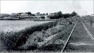
The railroad tracks in Seaside, 1917. (City of Seaside Archives)
East Monterey became Seaside prior to 1899 and grew slowly into a middle-class American neighborhood. Then, rather suddenly in 1910, Roberts decided to invite the US Army to set up camp on a part of his land. Camp Gigling was established two years later and many of the original residents of East Monterey moved out in response, disliking the sudden military presence on their doorstep. In 1914, Seaside was decisively turned into a military town. When the US entered World War I in 1917, the base went into full operations. After the war, the community continued to decline into what many saw as a lower-income town, marring the reputation of Monterey and Pacific Grove. The Great Depression did little to help this as many settled in the town since property values were low. Because of the settlers and the military base, the community became one of the most multi-racial areas along the Central Coast. By the time World War II began, many of Fort Ord's families and auxiliary staff lived in Seaside and this fact continued until the base closed in 1994. In 1954, the town incorporated into its own city, independent of Monterey, and it has continued to grow since World War II. Seaside continues to be a mixed-ethnicity community but it is no longer low-income, today supporting many established hotels, a golf course, CSU Monterey Bay, and a naval academy.

Railroad service to the station increased through the 1930s and 1940s, probably reaching a height in the 1950s before declining rapidly as regular passenger services ended. Freight service to Seaside remained intermittently, although what it serviced is not entirely known. Numerous small freight concerns existed in the area but changed frequently. Which, if any, of them used the Seaside freight platform after 1954 is unknown currently. The station became the end-of-track when the branch was truncated in 1979 and remained on timetables until the abandonment of the branch by the Union Pacific Railroad in 1999. When the station structure was removed is currently unknown.

Official Railroad Information:
East Monterey probably first appeared around 1889 with a class-A freight platform. It was renamed Seaside by 1899. In the 1920s, the station's platform was downgraded to a C-class freight stop, meaning it had a platform and siding but no other facilities. The stop was located 123.3 miles from San Francisco via Castroville, Gilroy, and San José. It was also 6.7 miles from the Lake Majella end-of-track. Initially, it offered both passenger and freight service and included a 10-car (~500 foot) siding at the stop. The siding shrunk down to ~450 feet by 1940 and then ~250 feet by 1951. Regularly-scheduled passenger service, except for specials such as the Del Monte Express, ceased in 1963 and the siding disappeared from timetables at the same time. In 1979, the Monterey Branch was cut back, with Seaside becoming the new end-of-track. The station remained on timetables until the closure of the branch in 1999.

Geo-Coordinates & Access Rights:
36.61˚N, 121.85˚W

The site of Seaside is beneath the Cardinale Nissan dealership on Del Monte Blvd. The parking lot marks the extent of the spur and station property while the siding ran from the end of Holly Street to just southwest of where the right-of-way passes over Contra Costa Street. Access to the right-of-way is largely open in this area, except for the Nissan dealership.

Citations & Credits:
  • McKibben, Carol Lynn. Images of America: Seaside. Arcadia Press, 2009.

Thursday, July 2, 2015

Prattco

Prattco Spur as shown on a 1948 USGS Map.
In the years just after the end of World War I, activity in the area of East Monterey, modern-day Seaside, was on the rise. It was in this environment that Clarence "Sandy" Pratt established his Pratt Rock and Gravel Company sand quarry on the beach along a spur of the Southern Pacific Railroad's Monterey Branch.

Prattco began operations in East Monterey in 1921 where it ran a single-pit quarry on the beach, nestled between two small sand dunes that still sit there today. The original quarry was serviced by a short 5-car spur that ran alongside the main track with the freight platform situated between them. In the early 1940s, the spur was lengthened considerably, running between the dunes and toward the Monterey Bay 750 feet. This length apparently was too long and it was shortened slightly, to 640 feet, by 1954. While no formal station structure was located there except for the platform, the station did accept passengers and even occasionally had scheduled service. Its location close to Fort Ord Village likely made it a closer stop for some local residents.

In 1950, Prattco was purchased by Pacific Cement & Aggregates, Inc., which used the sand from this quarry for concrete, blasting powder, and stucco. PCA scraped medium-grain sand off the beach and the dunes for processing on site, where it is sorted and blended. Lone Star Industries, Inc., a major aggregate supplier on the Central Coast, eventually purchased all of PCA, including the Prattco plant. Lone Star continued to use the quarry for many more years, with it finally shutting down at the end of 1986. The spur was spiked at some point soon afterwards and it is unclear if the tracks still sit, although aerial imagery shows the path of the spur. Regardless, Prattco remained on timetables until the abandonment of the Monterey Branch in 1999.

Official Railroad Information:
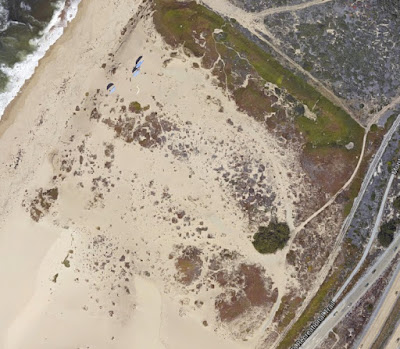
Google Maps satellite view of the Prattco spur today. The spur is gone, as is
its switch, but the imprint of it can still be seen in the sand dunes.
Prattco first appeared in agency books in the late 1910s. It was recorded as having a class-C freight station, including a short platform. Employee timetables reported in the 1930s that Prattco was located 122.1 miles from San Francisco via Castroville, Gilroy, and San José. In addition, it was 6.2 miles from 7.9 from the Lake Majella end-of-track. Both passenger and freight services were offered at the stop, although the station was primarily a freight stop for the Pratt Company. A 5 carlength spur (~250 feet) was installed at some point and lengthened into a 15 carlength (~750 feet) spur in the 1940s. It was reduced to its final length of 640 feet around 1954. The station was demoted to an "Additional Station" in the 1940s but returned as a regular stop in 1963. Freight service to the station persisted after the end of passenger service, only formally ending with the closure of the branch in 1999.

Geo-Coordinates & Access Rights:
36.62˚N, 121.84˚W

The site of Prattco is in Sand City just to the right of the Fremont Boulevard southbound exit of State Route 1. The Monterey Peninsula Recreation Trail passes beside the site, as well. Access to the site is ambiguously restricted, but a lack of development in the area suggests trespassing is not discouraged. The old Prattco road, now covered in sand, can be found at the northern end of Fremont Boulevard.

Citations & Credits:

Friday, June 26, 2015

Workfield

The Work Wood Yard, c. 1895, with Thomas in front (Pat Hathaway)
At the turn of the twentieth century, the area near what would become Fort Ord was largely undeveloped property. Nearby in Pacific Grove, however, a Scotsman named Thomas Albert Work was making a name for himself. He was an investor and promoter, a man who wanted to see his town becoming something special. Young and presumptuous, the man began his life at the age of 17 as the owner of a feed store and wood yard in 1886. His business expanded exponentially over the next two decades, bringing him wealth and regional fame. By 1903, he had erected the first motion picture theatre in Monterey, sacrificing his credibility for the hope of filling a growing niche. His investment paid off wonderfully. He became involved in local politics and took on investors. His theatre was still at the center of city life into the 1930s, during which time he was also the president of the First National Banks of Pacific Grove, Salinas, Monterey, and Carmel, as well as the city's treasurer. He also purchased vast tracts of land and many rival businesses over the decades, becoming the equivalent of Frederick Hihn on the Monterey Peninsula. 

Map showing Workfield Siding just south of the Fort Ord loop, 1948. (USGS)
But in western Monterey, he had another project located directly beside the Southern Pacific Railroad's Monterey Branch. In 1914, Work purchased 8,000 acres of land to the east of the tracks and converted it into Workfield Farms. This property appears to have been primarily a dairy and cattle ranch. The railroad ~420-foot spur established for the property, so-named "Workfield", probably was used to haul out stock of cattle periodically.

The United States Army purchased the Workfield property around 1940 during its massive expansion of Camp Gigling into Fort Ord prior to World War II. Workfield probably ceased regular use at this time, although it is possible that the military used it for holding cars. Some sources call the location "Gigling Junction", however this term was strictly unofficial and the location never served as a junction to anything. The spur was reduced to ~280 feet and converted to a short siding and scheduled passenger service ended, if ever it had it. The siding lingered through the 1950s, but was gone by 1963.

Official Railroad Information:
Workfield first appeared in railroad timetables and agency books around 1916, operating as a C-class freight station with a platform. It was located 120.4 miles from San Francisco via Castroville, Gilroy, and San José and 9.6 miles from the Lake Majella end-of-track in Pacific Grove. The initial 12-carlength spur was shortened to an 8-carlength siding in the late 1940s and the station was removed from timetables by 1963.


Geo-Coordinates & Access Rights:
36.64˚N, 121.82˚W

The former location of the Workfield siding is directly across State Route 1 from the end of Gigling Road. It can be accessed via the Monterey Peninsula Recreation Trail just south of the concrete loading platform that runs off the Fort Ord Loop track. The only lingering evidence of the siding is a section of ballasted ground to the east of the right-of-way.

Citations & Credits:

  • Seavey, Kent. Images of America: Pacific Grove. Arcadia Publishing, 2005.
  • Van de Grift-Sanchez, Nellie. California and Californians, vol. 4. Lewis Publishing, 1932.
  • Walton, John. Storied Land: Community and Memory in Monterey. Berkeley: University of California Press, 2001.

Friday, June 19, 2015

Gigling & Ord

Fort Ord Army base in 1948 (USGS)
The history of Fort Ord and its relationship with the Southern Pacific Railroad dates back to the very beginning of the Salinas Valley Railroad in 1874. When that railroad first connected the Monterey pier with Salinas, the location that would become Ford Ord was a ranch owned by the Gigling family. Not much is known about the Giglings except they were German immigrants and primarily cattle and sheep ranchers who had settled on the boundary between Ranchos El Toro and El Chamisal and the Pueblo of Monterey in the 1850s. When the railroad passed through their land, the family was able to have a flag-stop erected under the name "Gigling's", and local ranchers such as the Henneken family used it to ship out goods.

Camp Gigling cavalry unit, 1917. (EastGarrison.com)
In 1904, the Presidio of Monterey began using the area around the Gigling farm for training exercises. The presidio's cavalry and Army regiment camped periodically on the dunes near the beach but it was only in 1917 that they began to use the land more formally. On August 4th of that year, the US Army purchased 15,610 acres of land from the David Jacks Corporation (presumably the successors to the Gigling family) and converted it into "Gigling Reservation". Little changed at the site except the animals were removed. The reservation consisted only of an old well, a caretaker's house, and a few semi-permanent bivouac sites. The railroad stop, connected by a little-used dirt road to the camp site, continued to be used by local farmers and a freight platform catered to their needs, but how heavily this stop was used remains unknown and it seems to have declined in use through the early 1930s. Gigling Reservation became Camp Gigling at some point after World War I, but the old name was retained by many locals into the late 1930s. The camp supported the 76th Field Artillery Regiment, 3rd Infantry Division, and the 18th Cavalry. It's main purpose became field artillery training, a legacy that still haunts the area today.

Bivouacking cavalry soldiers preparing for a day of training at Camp Gigling, 1917.
(Mayo Hayes O'Donnell Research Library)
Gigling Artillery training, 1917 (Calisphere)
The Great Depression changed many things at Camp Gigling. The Civilian Conservation Corps set up an outpost there in 1933 and the military, responding to the growth of the base, renamed the entire facility "Camp Ord" after the Civil War commander Major General Edward Otho Cresap Ord. The property was expanded to encompass an additional 13,000 acres and permanent facilities began to be erected on this new land, demoting the former Camp Gigling property to the status of "East Garrison", although the railroad station retained its old name until the early 1940s when it became "Ord". Immediately prior to World War II, the base expanded exponentially to include barracks, mess halls, sewage treatment facilities, and administrative buildings—over 1,000 separate buildings in total. In 1940, the base became "Fort Ord" and was commissioned as a full-time US Army facility under the control of the 7th Infantry Division.

The Gigling/Ord Loop track with a passenger train turning around, March 13, 1949. (Wilbur C. Whittaker)
During World War II until the end of the Vietnam War, Fort Ord was a basic training facility and boot camp for soldiers of the 7th Light Infantry Division, as well as other divisions as needed. The railroad service at Ord exploded during the wars, with the short 18-carlength siding (~630 feet) being converted into a multi-siding holding yard with accompanying turn-around loop. The loop, which still exists just south of the base today, allowed trains to turn around without the need of a turntable or wye. Combined, the track space at Ord encompassed 3,430 feet of track, enough to hold 97 passenger cars. The mainline tracks bypassed the fort but a long siding with two spurs went directly into the base to expedite troop deployments. A long siding also ran along the entire length of the mainline in this area, presumably to hold excess cars. Most of this track remains intact today, although much is buried, spiked, or in a general state of disuse since the line itself is no longer operable.

Basic training at Fort Ord during the Vietnam War.
(San Luis Obispo's The Tribune)
Fort Ord began to decline as an army facility after 1975 and in 1990, the US Department of Defense listed the base for closure. Formal downsizing began in 1991 and the 7th Infantry was relocated to Fort Lewis, Washington. The base officially closed in September 1994, although a small portion of it remains in use by the Presidio of Monterey, primarily for their Defense Language Institute. Since its abandonment, the fort property has undergone various changes. A large portion of it has become California State University, Monterey Bay, while other parts have been cleared out for use as retail space. Two decades have been spent making safe the old artillery yards with Army crews regularly searching for unexploded ordnance in the fields, but the majority of this land is returning to a state of nature, as intended. The Monterey Bay Rail Trail begins its journey along the historic Monterey Branch right-of-way near Fort Ord and continues to Pacific Grove, although the track itself still exists, usually sitting beside the trail, rusting and unkempt. President Obama created Fort Ord National Monument in April 2012, although the new park is still undergoing conversion before it becomes fully accessible to the public.

Official Railroad Information:
A train on Gigling loop, March 13, 1949. (Wilbur C. Whittaker)
When precisely Gigling appeared in timetables is not currently known to this historian, but it was listed as early as 1899 in Agency Books as a class-A freight stop. It was downgraded to a class-D station in 1909 and retained that status into the early 1930s. By 1937, Gigling was a formal station once again with an 18-carlength siding, phone access, and both passenger and freight services. It was located 119.7 miles from San Francisco via Castroville, Santa Cruz, and the Mayfield Cut-Off. Following the closure of the mountain section in 1940, the distance shifted to 119.2 miles via Castroville, Gilroy, and San José. It was located 10.3 miles from the Lake Majella end-of-track. In the mid-1940s, the Gigling loop was added to the stop, thereby lengthening the track to 97-carlengths, or 3,430 feet. Regular passenger service to the station ended around 1965, although it remained as a flag-stop for the Del Monte Limited until 1971, but freight access through the stop continued until the closure of the branch in 1999.

Geo-Coordinates & Access Rights:
36.66˚N, 121.82˚W

The site of Gigling loop is currently blocked to public access but the switch can be viewed from the Monterey Bay Rail Trail. Similarly, fortunately, a branch of the rail trail passes directly beside the old soldier-loading station at the base itself, with the siding and spurs appearing near the southern end until the trail overtakes the tracks. The long siding beside the base still can be seen, as well, both from the trail and from Google Maps' satellite view.

Citations & Credits:

Friday, June 12, 2015

Marina

The small city of Marina located on the northern fringe of the Monterey metropolitan area began life as an outlying property of Fort Ord in the 1840s and the ranchos of David Jacks and James Bardin. In 1885 and 1886, Bardin sold most of his land to various farmers, livestock farmers, and the San Francisco Sand Company. The rest of the land remained undeveloped. William Locke-Paddon purchased in 1913 a 1,500 acre parcel near the beach which he initially named "Locke-Paddon Colonies", though it quickly became known as "Paddonville". Locke-Paddon planned to subdivide the property into 5-acre plots for families to create small farms, but few people were interested and the area did not develop quickly.

Soon after the town was established, a flag-stop under the same name opened alongside the Southern Pacific Railroad's Monterey Branch near the intersection of Del Monte Boulevard and Reservation Road under the name "Paddonville". Locke-Paddon didn't like the name and changed it to "Marina' in 1918, with a post office under that name being registered in April 1919. Curiously, the town did not have, nor ever has had, a marina, but the name stuck all the same. The primary purpose of the flag-stop was to attract Bay Area vacationers to move into the seaside settlement, but Locke-Paddon still had little success. He parcelled out land for a school and church, attracting some of the military staff officers from nearby Fort Ord began moving into some of the lots. The post office expanded into a general store in 1920 with petroleum service installed soon afterwards to attract the increasing automobile traffic.

Comparison photograph of Marina station in 1948 and the station site in 2005.
(Top photograph by Paul Loyola Henchey, bottom by Pat Hathaway)
By 1926, 70 families lived in town and the area was finally seeing development. More roads were added connecting Marina to Fort Ord and Camp Gigling and the coming of World War II turned Marina into a place where soldiers on leave could pass the time. The railroad upgraded its station in 1926 to full service with scheduled stops and a 450-foot-long spur was installed beside the tracks to park freight cars for local produce shipments. A freight tool shed was established atop a short platform at the end of the spur by 1948, although no passenger platform or shelter was ever erected. The spur was extended by 1951 into a 650-feet siding before being reduced to 400-feet in 1954. The Paradise Lodge, the first large hotel in the city, opened in 1953. Meanwhile, the Del Monte Special brought in many visitors each week.

The town finally incorporated as a city in 1975. However, railroading had ended by this time. Passenger service on the Monterey Branch ended in May 1971 and freight service became infrequent. From 1963 to 1996, Marina remained on the freight schedule but the siding went into disuse and may have been removed. Fort Ord closed in 1991 but in 1994 California State University, Monterey Bay, opened on a part of the former base and the city evolved into a college town. Today, the area around Marina is still largely undeveloped swampland and sand dunes, but a small commercial center and thriving residential population has turned it into a safe and popular area for families.

Official Railroad Information:
Nothing appears in railroad timetables or agency books until the 1910s regarding Marina. The station first appeared in Agency Books as "Mile Marker 117" in 1916 and then became "Paddonville" the following year. From 1919, the station was named "Marina". It was located 117.3 miles from San Francisco via Castroville, Gilroy, and San Jose. It was 11.0 miles from the Lake Majella end-of-track. A 9-carlength spur was associated with it since at least 1937 and that spur was extended into a 13-carlength siding by 1951. Curiously, in 1940 and 1954 Marina was listed only as an Additional Station. In 1954 the siding was reduced to 8 carlengths, although it remained a siding, and from 1963 no siding or spur were associated with the stop. The station remained on timetables until the end of Southern Pacific ownership of the line in 1996. Whether it appeared on Union Pacific Railroad timetables afterwards is unknown, but the branch was spiked at Castroville in 1999.

Geo-Coordinates & Access Rights:
36.687˚N, 121.800˚W

The site of Marina station is beside the tracks between Del Monte Boulevard and Marina Drive, approximately at the latter road's northern terminus. A Starbucks is across the street from it and there are no access restrictions to the location. Nothing remains of the stop except the tracks.

The site of Marina Station at the northern end of Marina Drive. (Google StreetView)
Citations & Credits:

Friday, May 29, 2015

Bardin

Bardin Station shown on a slightly incorrect 1913 USGS Map.
Despite there being a number of stops associated with the Bardin family on the Pajaro Valley Consolidated Railroad line, there was only one such stop on the Southern Pacific Railroad, located midway between Lapis and Marina under the name "Bardin's".

James Bardin was a North Carolinian farmer who crossed the plains in 1855 to settle in the Salinas Valley. Soon after his arrival, he purchased 1,220 acres of Rancho Ríncon de las Salinas from Rafael Estrada. From there, Bardin began his local property empire, especially turning the town of Blanco from a small hamlet into a town peopled primarily by his own descendants. In 1858, his holdings had expanded to 5,000 acres. In addition to his property holdings and his farm, Bardin operated a ferry across the Salinas at a place called Anton's Crossing. Bardin's son, James Alfred, became a superior court judge and was prominent in Salinas area politics.

Closer to the beach near the mouth of the Salinas River, Bardin sold a stretch of land to the Monterey & Salinas Valley Railroad Company, which became the Southern Pacific Railroad in 1879. Bardin was one of the original financiers of this route, which linked his properties to both the port of Monterey and the markets of Salinas. In fact, Bardin's ranch was located at the bend in the railroad—the place where it turned sharply southwest from its otherwise westerly direction. He grew primarily barley and potatoes on his land using Chinese labor. Once Claus Spreckles began investing in the area, Bardin switch to growing sugar beets on his property. All of these were probably shipped via his various freight stations such as that at Bardin's.

James Bardin himself died in 1888, but his seven sons continued to own the land well into the 1930s. The death of James Alfred Bardin in 1932 may have marked an end to freight shipments out of Bardin station. Except for a short siding at the stop, shown on the USGS map above in 1913, no structures or facilities were ever associated with the stop. Indeed, by the 1930s it seems the siding had been reduced to a simple spur, possibly only a remnant of the longer siding. The stop was removed from timetables entirely in the 1940s, after which service was probably replaced by truck. James Bardin's descendants still run some farms in the Salinas Valley, primarily at Rancho Cienega del Gabilan, but the area around Bardin station is now undeveloped city land.

Official Railroad Information:
Bardin's appeared in agency books before 1899. It was a class-A station and included a freight platform. It lost the "s" in its name around 1907. The station was included on employee timetables from at least 1909, located 115.4 miles from San Francisco via Castroville, Gilroy, and San José. It was 12.9 miles from the Monterey Branch end-of-track at Lake Majella. By 1937, the station permitted both passenger and freight service and included an 8-carlength spur (~400 feet), although the freight service there had been reduced to a class-C station. No other services were provided at the stop. The station was downgraded to an "Additional Station" in 1940 and disappeared entirely from timetables at some point before 1951.

Geo-Coordinates & Access Rights:
36.706˚N, 121.79˚W

The site of Bardin is located near the southern junction of Del Monte Boulevard and Lapis Road. No remnant of this spur remains today and the land beside it is undeveloped Monterey city land.

Citations & Credits:
  • Anderson, Burton. America's Salad Bowl: An Agricultural History of the Salinas Valley. Salinas, CA: Monterey County Historical Society, 2000.
  • Clark, Donald Thomas. Monterey County Place Names: A Geographical Dictionary. Scotts Valley, CA: Kestrel Press, 1991).

Friday, May 22, 2015

Lapis

1913 USGS Map showing Lapis and its long spur.
The station that began its life in 1908 under the name "Stone" evolved quickly the next year into Lapis Siding. The name may derive from the gemstone, lapis lazuli, although no such gemstone appears to have been found there. The cement manufactured using a mixture Lapis sand is often sold as "Lapis Lustre", although the origins of this word combination are unknown.

The mine was originally operated by Egbert Barker and Andrew Lysander Stone beginning in 1906 to help the reconstruction projects in San Francisco following the 1906 earthquake. Lapis has always been and is still a sand mine. The railroad associated itself with Lapis two years after the mine was established, although it may have operated earlier albeit unregistered. The long spur to the beach wrapped southward in a gentle arc. Originally, there was a siding that ran much of its length and a second siding near its terminus. The spur forked at the end with one spur turning back into the plant. A freight platform was only installed much later. The property changed hands multiple times over the years and by the 1940s, it was being mined by Pacific Coast Aggregates as their Number 10 plant. It was an extensive operation with support tracks that measured over a mile in length from its switch off the Monterey Branch beside State Route 1 (now Lapis Road). The new arrangements of he tracks saw them branching three times, with one spur operating off of a switchback at the beach. The siding along the gentle curve of the track remained in place.

1948 USGS Map showing Lapis Siding and the Pacific Coast Aggregates
Company plant (#10) at the end of a spur track.
Today the facility, now owned by CEMEX, no longer uses the railroad tracks, although the tracks still terminate at the plant. The quarry uses hydraulic pumps to dislodge rock and relocate sediment. It is an extensive operation despite its small size; over 3 million tons of sand are shipped out each year from the Lapis plant. Its primary processing plant is visible today from State Route 1, often with a small spout of steam ejecting above the primary kiln. The site is currently being considered for a desalinisation plant, although political opinion is currently against the prospect.

CEMEX Sand Quarry as seen from above. (Google Maps)

Official Railroad Information:
The station first appeared in 1908 under the name "Stone". The Agency Book for that year records no facilities at the stop. In 1909 it was renamed "Lapis" and was classified as a C-type freight stop with no platform or other services. A platform was finally installed at some point in the 1920s.

Lapis was registered as permanent flag-stop on the Monterey Branch in 1937. It was located 114.8 miles from San Francisco via Castroville, Gilroy, and San José, and 13.5 miles from Lake Majella. It had a 23-carlength spur (~1,150 feet) and no other freight services. The station was downgraded to an additional stop by 1940. The spur was greatly lengthened in the late 1940s to 115-carlengths (~5,750), likely representing an expansion of the spur into multiple branches, as shown on the 1948 map above. Passenger service to the stop was discontinued at this time. The station remained on timetables as an "Additional Station" into the 1990s and probably until the abandonment of the branch by the Union Railroad in 1999. Lapis's spur length in 1974 was recorded as 5,635 feet and this seems to closely match the tracks still present on the spur today.

Geo-Coordinates & Access Rights:
36.715˚N, -121.793˚W

The site of the Lapis switch as well as the entirety of the spur is owned by CEMEX. No trespassing is allowed. The switch can be viewed from Lapis Road just north of the CEMEX plant turn-off.

Lapis switch today as seen from Lapis Road. (Google StreetView)
Citations & Credits:

Friday, May 15, 2015

Martin & Neponset

1913 USGS Map showing Neponset just south of the Salinas River.
The northern part of Monterey County has never been heavily developed. With the agricultural wealth of the Salinas Valley, plants more than people occupied the great river basin. Neponset, a Southern Pacific Railroad station located just south of the Salinas River along the Monterey Branch, never belonged to a town. The station was located on the edge of Rancho Rincón de las Salinas (corner of the salt marshes). The grant was originally given to Cristina Delgado in 1833. After the United States annexed California, the rancho was patented to Rafael Estrada.

When the Southern Pacific purchased the Monterey & Salinas Valley Railroad in 1879, it constructed a new reroute of the former line between Castroville and Bardin's. Because of the pair of bridges that were required to cross over the Salinas River, the area picked up the nickname "Twin Bridges" (today, there are three bridges over the river here, two for cars and one five-truss span for trains). At the same time, the railroad established a station just to the south called "Martin's Station" and, later, "Martins". Who the name referred to is not presently known by this historian. The local settlement itself appears to have been located on the Monterey Bay slightly to the west, but a freight platform and siding were built alongside the tracks to support the local community. Passenger and freight service both went through the station. What precisely was shipped out of here is not entirely known. Agricultural products undoubtedly were one of the items, but salt from the Salinas River and the beach, or other ocean-related products may also have shipped out from here.

The station was renamed one last time around 1899 to "Neponset", after the Massachusetts town of the same name, which itself was a Amerindian word meaning "little summer place". Once again, the reason for the name is not currently known. Neponset reached its height in the 1920s when a water tower was installed there and its siding reached its maximum length of around 700 feet. Starting in the 1930s, it began to shrink again and passenger service ended during World War II. The station was removed from timetables around 1960.

Today, a small spur, reduced from its original siding, remains at Neponset along the now-abandoned and spiked Monterey Branch. A large industrial park occupies the site adjacent to the station. Parts of the former freight platform and station structure may survive within the facility's parking lot, although this is not clear from Google Maps. Though Neponset is still considered an unincorporated community in Monterey County, very few people live there today and it is primarily undeveloped or agricultural land.

Aerial view of Neponset today. The extant spur is visible in the profile of the driveway at top. (Google Maps)
Official Railroad Information:
Neponset was located 113.9 miles from San Francisco via Castroville, Gilroy, and San José, and 14.7 miles from Lake Majella. It included a 14-car siding (~700 feet), a water tank (installed in the 1920s), a class-A freight yard with platform on the south side of the tracks, and supported both freight and passenger service. By 1951, the station no longer supported passenger service and its siding shrunk to only 9-carlengths (~450 feet). The station was removed from Southern Pacific timetables by 1963.

Geo-Coordinates & Access Rights:
36.73˚N, -121.78˚W

The site of Neponset is located along Monte Road, a frontage road beside State Route 1 just south of the Salinas River crossing. The railroad tracks and siding (now a spur) still exist outside a restricted-entry industrial park. The spur breaks off just at the driveway. The station and platform probably sat between the tracks slightly to the southwest of the driveway, the current site of the business's staff parking lot. Neponset Road wraps around the industrial park on its south side.

Citations & Credits:
  • Mildred Brooke Hoover, Historic Spots in California (Palo Alto, CA: Stanford University Press, 1990).

Friday, May 8, 2015

Morocojo & Nashua

1948 USGS Map showing Nashua station on Nashua Road
(former Pajaro Valley Consolidated Railroad right-of-way).
The small settlement of Rancho Bolsa del Potrero y Moro Cojo, also known as La Sagrada Familia or more simply, Morocojo, began life as a Mexican rancho. The original grant was for 6,916 acres on the north side of the Salinas River near its outlet to the Monterey Bay. It was one of the earliest confirmed Mexican land grants in the state, given in 1822 by Governor Pablo Vicente de Solá to José Joaquín de la Torre. Its neighbor to the north was the similarly named Rancho Bolsa Nueva y Moro Cojo.

Torre had been a Spanish soldier and the alcade (mayor) of Monterey before becoming the secretary of Governor Solá. He was married to Maria Los Angeles Cota in 1803. Torre may never have settled on the property and sold it to an Englishman, John Bautista Rogers Cooper, in 1839. Torre later was granted Rancho Arroyo Seco and settled there in the 1840s. Cooper was not just any settler, he was a captain of a ship and the son-in-law of General Mariano Guadalupe Vallejo. He settled on Potrero y Moro Cojo and his property was patented by the United States government in 1859.

Cooper had died in 1872 but he left two daughters behind who undoubtedly inherited the land. Whether a station was erected at this time is not presently known to this historian, but it seems possible. Around 1880, a connecting line between Castroville and the Monterey & Salinas Valley Railroad track at Bardin's was built across the Cooper family land. It passed directly through the heart of the rancho, requiring a long and disruptive easement, and it seems most likely that the family negotiated a stop for their agricultural products in exchange. The fact that the station was known as Morocojo, the name of the rancho, until 1912 reinforces this point.

When the Pajaro Valley Railroad passed through in 1891, it originally ended at the Morocojo junction with the now-Southern Pacific Railroad's Monterey Branch. Over the next decade, the route was extended to Spreckles near Salinas, with the two railroad lines more or less quartering Rancho Morocojo. Southern Pacific timetables noted the crossing with the Pajaro Valley Consolidated Railroad in its timetables, although there appears to have been little interchange here. The PVCRR did not even note the crossing, placing its Moro Cojo stop slightly to the southeast near a second stop for the rancho named Cooper. The PVCRR maintained a total of five stops within the rancho, although by this point the rancho property had probably been divided into various smaller parcels. Claus Spreckels leased portions of the property to grow sugar beats for his two local refineries and likely used these five stops to make shipments out of the area easier. The Southern Pacific station may have been used for similar purposes by Spreckels, especially prior to 1891.

For another decade, Morocojo remained a stop on the Monterey Branch until the railroad inexplicably in 1912 renamed the station Nashua. Nashua remains even today an unincorporated community in Monterey County, but there is almost nothing there anymore. Presumably more was there in the 1910s-1930s, but it seems doubtful there was ever a thriving town. In the USGS map for 1948, only the station and a few small structures are noted at the site of the junction. It is possible the area was more popular prior to 1929 when the Pajaro Valley Consolidated Railroad shut down. Once the crossing was closed and the right-of-way converted into Nashua Road, the locals only had the Southern Pacific Railroad to haul its goods. With the Great Depression starting at the same time, exports from the area undoubtedly declined, while the rise of the automobile and automated farming likely ended any need for the station. By 1951, Nashua no longer appeared in timetables.

A Google Streetview image of the Nashua Station site. The tracks now sit beneath Nashua Road, the former right-of-way
of the Pajaro Valley Railroad. The signal sits idle, turned away, its crossing gate long removed.
Official Railroad Information:
Mojocojo probably appeared in timetables as early as 1874, when the Salinas Valley Railroad first passed through the area. By 1899, it had a class-A freight platform but no other facilities at the site. It was located 112.4 miles from San Francisco via Castroville, Gilroy, and San José, and it acted as the crossing station for the Pajaro Valley Consolidated Railroad. The station served primarily as a flag-stop but did appear on timetables with a schedule. It was 18.0 miles from Lake Majella. Mojocojo was renamed Nashua in 1912.

Nashua was located 112.3 miles from San Francisco via Castroville, Gilroy, and San José. The station was reduced to a C-class freight station in the 1920s, although it retained its platform. The facilities there in 1940 included a 14 car-length siding (~700 feet) and both passenger and freight facilities. Nashua as a geographic location appears to have disappeared in the late 1940s as it ceased appearing on timetables in 1951.

Geo-Coordinates & Access Rights:
36.741˚, -121.765˚

The site of Nashua Station is located at the eastern corner of Nashua Road with Monte Road. Today, there is only a field there, with a small maintenance facility located just to the east of it. The railroad tracks no longer cross the road, being paved over in the 1990s, and the signals, still present, are turned away, their bars removed.

Citations & Credits:

  • Still looking for better sources!

Friday, May 1, 2015

Gay

The Monterey Branch of the Southern Pacific Railroad's Coast Division had its fair share of obscure stops just as the Santa Cruz County sections had, but few are as obscure as Gay. Located only 1.1 miles south of Castroville along the branch, the station first appeared in the late 1940s and persisted for hardly a decade before quietly disappearing. It may have succeeded Nashua as a stop, which had been located about a mile to the south and disappeared in the 1940s (Nashua itself had replaced Morocojo at some point), but the distance between the two stops makes that assessment questionable. In all likelihood, Gay was an agricultural stop named after a local property owner. A long half-mile-long siding at the stop reinforces the assumption. USGS survey maps of the 1950s show such a siding on the north side of the tracks running the length between Tembladero Slough and an irrigation canal. There was never any passenger service at Gay and it seems unlikely that there was any permanent structure there except for a station sign. No evidence of a station or siding remains today and the now-abandoned tracks of the Monterey Branch peacefully pass through the fields without interruption.

Official Railroad Information:
Gay first appeared on the 1951 Southern Pacific Coast Division timetable and disappeared by 1963. It was located 111.5 miles from San Francisco via Castroville and San José. It maintained a spur and siding space for 73 cars (~3,650 feet).

Geo-Coordinates & Access Rights:
36.746511, -121.755179

The site of Gay is located along the Monterey Branch midway between Castroville Road and Nashua Road immediately prior to passing over an irrigation canal. The site today is in the middle of an agricultural field and is undoubtedly privately owned with an easement provided for the railroad tracks. Trespassing is not recommended.

Citations & Credits:
  • Southern Pacific Coast Division timetables, 1941-1963.