Showing posts with label Monterey County. Show all posts

Friday, January 24, 2025

Curiosities: Coastal Shipping

Santa Cruz County did not always have rail services. Before 1876, travel to the remote northern cove of the Monterey Bay was difficult, with roads sometimes impassible and seas too rough to travel. Ultimately, it was ocean-going vessels and coastal steamers that dominated the early Santa Cruz freight industry, resulting in a series of wharves erected at the ends of Bay Street, Pacific Avenue, and Main Street. But what were the companies that used these structures and when and why did they stop visiting the Santa Cruz waterfront?

The SS Roanoke beside the Santa Cruz Municipal Wharf on opening day, December 5, 1914. [University of California, Santa Cruz – colorized using MyHeritage]

Santa Cruz had been a seaport long before it became a US state. The Spanish mission used the Santa Cruz Main Beach to receive supplies from Mexico and the produce from the mission and the spring on Beach Hill refuelled ships' supplies. By the early 1840s, people like Isaac Graham used oxen and horse teams to haul lumber to the beach, where it was loaded onto boats and transferred to ships anchored offshore. It was a tedious process and led to only small profits. In 1846, Graham and his business partners built their own ship on the beach, the first of many to be named Santa Cruz. It was followed soon after with a second Santa Cruz and the Zach Taylor. These small ships, though, would hardly be able to compete with the larger vessels that would soon run along the Central Coast.

"Bird's Eye View of Santa Cruz," by Charles B. Gifford, showing steamships and tall ships off Davis & Cowell's wharf and Gharky's wharf, ca 1872. [Bancroft Library – colorized using MyHeritage]

As the lumber and leather industries were gradually supplemented by commercial agricultural products, quicklime, blasting powder, and other types of freight, the need for a reliable means of transferring freight to ships increased. Cowell's wharf, originally built at the end of Bay Street as a simple chute in 1849 by Elihu Anthony and Edward S. Penfield to load ships with potatoes, evolved into Santa Cruz's first industrial wharf. This was followed in 1857 by David Gharky's wharf at the end of Main Street. The Railroad Wharf at the end of Pacific Avenue joined the pair in 1876, connected to Gharky's wharf with a viaduct from 1877 to 1882. Finally, in December 1914, the Santa Cruz Municipal Wharf was completed. Other landings and wharves existed at times in the county, too, at Waddell's Beach, Davenport Landing, William's Landing, Soquel Wharf, Aptos Wharf, and Watsonville Landing.

The SS Ancon at the Railroad Wharf, ca 1877. Photo by Romanzo E. Wood. [Chico State University – colorized using MyHeritage]

By the mid-1870s, Santa Cruz was the busiest seaport on the California coast outside of the San Francisco Bay. The three wharves did a bonanza business shipping the redwood timber and quicklime that was rapidly building the nearby metropolis. Explosive powder from the California Powder Works were shipped to the Gold Country for mining, to timber tracts to destroy stumps and other obstacles, to railroads to grade their routes, and to the New Almaden quicksilver mines to bore new tunnels. People were also visiting Santa Cruz, primarily to enjoy the bathing beach beside the outlet of the San Lorenzo River, which was conveniently located directly beside and between the wharves. The Leibbrandts and Liddell families worked hard to attract visitors during the summer months, ever expanding their bathing pavilions and adding amenities. In the mountains, resorts were also opening up at the Welch's Big Trees Grove, Hotel de Redwood, Olive's Sulphur Springs, and elsewhere.

A steamship, possibly the Fannie Gilmore, loading barrels of quicklime at the bottom of Cowell's wharf, ca 1890. [Santa Cruz Museum of Art & History – colorized using MyHeritage]

In the earliest years, a variety of companies sent ships along the California coastline to call at its ports, most notably the California Steam Navigation Company, which in 1867 became the California, Oregon, and Mexico Steamship Company and in 1869 the North Pacific Transportation Company. These companies mostly ran schooners specially outfitted for coastal shipping, often featuring both steam-powered paddle-wheels and wind-powered rigging. Davis & Jordan purchased a steamship of their own in 1857, yet another Santa Cruz, and used it to transport quicklime to San Francisco. The cost of operating the ship and the loss of business to Gharky's wharf after 1857, though, led them to downgrade to the smaller Fannie Gilmore. By this point, Santa Cruz was undeniably a seaport even if the ships calling were from a broad array of commercial shipping firms.

Cowell's wharf with a steamship docked and the Railroad Wharf in the distance, ca 1900 [UC Santa Cruz – colorized using MyHeritage]

It was not until 1875 that a major coastal shipping concern began operating out of the port on a regular schedule. The Pacific Mail Steamship Company had been founded in 1848 to handle the delivery of US mail along the Pacific Coast. Its mainline ran from the Panama Isthmus to San Francisco, and it did a bonanza business shortly after its founding as the California Gold Rush took off. It only took a passing interest in intermediate ports for the first 25 years of operation, but by the mid-1870s it was looking to expand and Santa Cruz was a logical destination. Its ships called into port regularly, causing Gharky's wharf to be renamed the Steamship Wharf in local parlance. The company's dominance did not last long, though.

A steamship heading docking at the Railroad Wharf, ca 1900. [UC Santa Cruz – colorized using MyHeritage]

In early 1876, around the time that the Railroad Wharf was completed, Goodall, Nelson and Perkins began running its own steamships along the Central Coast, mostly using older ships acquired in 1875 from the Pacific Mail Steamship Company. They initially called at the Railroad Wharf since their business was primarily transporting the lumber brought in from the San Lorenzo Valley flume. However, they also had a well-regarded passenger service with modern ships that outpaced those of their rival. Ratcheting up the competition, on October 17, 1876, the company reorganized itself as the Pacific Coast Steamship Company, a name meant to put fear in the hearts of the Pacific Mail Steamship Company's board of directors. The firm established a local office at the end of Pacific Avenue near the base of the Railroad Wharf and across from the Santa Cruz & Felton Railroad's main office.

Painting of the SS Senator, 1848, by James Bard. [Mariners' Museum and Park, Newport News, VA]

While the two firms fought over routes to the Pacific Northwest, they mostly cooperated in shipping freight from Santa Cruz. In 1877, to increase efficiency and the safety of shipping blasting powder, the Railroad Wharf and Gharky's wharf were connected by a viaduct with railroad tracks. This meant that steamships of either company, or other firms, could dock at either wharf and receive the same level of service. The opening of the Santa Cruz Railroad in 1876 seems to have had little impact on shipping since it was still cheaper to ship most freight out of Santa Cruz via steamship than rail. Passenger service, though, may have begun to decline from this time as passengers generally preferred the gentle ride of a railroad compared to the rolling and longer voyage of a coastal steamship.

Lumber being loaded onto a tall ship docked at the Railroad Wharf, ca 1900. [UC Santa Cruz – colorized using MyHeritage]

The beginning of the end came early. In May 1880, the South Pacific Coast Railroad opened between Santa Cruz and Alameda. This route made shipping by rail substantially cheaper and provided even more incentives for passengers to take the train. For a short time, many industries used both methods of transport, especially after the Southern Pacific Railroad took over the South Pacific Coast in 1887, immediately increasing prices. However, the end was inevitable. In 1880, the Pacific Mail Steamship Company abandoned all attempts to compete with the Pacific Coast Steamship Company and shifted its focus to Central America and trans-Pacific shipping. This left the latter company with a virtual monopoly over freight and passenger services out of Santa Cruz. Its only competitor was Davis & Cowell, who used their own ships and reluctantly began using the railroad as well.

Barrels being hoisted onto the SS Margaret at either the Railroad Wharf or the Santa Cruz Municipal Wharf, date undetermined. [UC Santa Cruz – colorized using MyHeritage]

Southern Pacific finally stabilized its rates around 1890s, successfully undercutting shipping rates while still charging more than was probably necessary for its services. The California Powder Works would continue to ship powder out from the Railroad Wharf until around 1900, but most other firms shifted to one of the rail lines out of the county. The widespread expansion of rail networks across the Central Coast in the 1880s and 1890s led to the collapse of the Pacific Coast Steamship Company in the Panic of 1893. The company was revived under new owners in 1897 but its focus shifted further and further north, especially during the Klondike Gold. Within a decade, almost all regular coastal passenger service was ended with the company focusing instead on long-distance travel between key Pacific ports, among which Santa Cruz was no longer counted.

The Railroad Wharf with a steamship docked beside it and the pleasure ship Balboa anchored in the Monterey Bay, ca 1907. Photo by James E. Boynton. [Santa Cruz Museum of Art & History – colorized using MyHeritage]

The decline of commercial steamship service was felt quickly in Santa Cruz after the expansion of the railroads. In 1882, the Steamship Wharf was demolished, as was its connection to the Railroad Wharf. There was simply not enough traffic to justify three commercial wharves at the waterfront. Cowell's wharf thrived for another 25 years, but when a winter storm damaged it in 1907, the Henry Cowell Lime & Cement Company changed its policy and began using the railroad more heavily. Once the line through the mountains was reopened in 1909, it completely abandoned its old wharf and the commercial shipping service it had run for over 50 years. The Railroad Wharf, meanwhile, had been largely taken over by Italian fishing families by 1910, though it was briefly cleared of shacks around the time that the Municipal Wharf was erected beside it in 1914. However, with the new wharf available for steamship service, the Railroad Wharf became a fishing hub with a cannery and other facilities installed.

The SS Roanoke docked at the Santa Cruz Municipal Wharf on opening day, December 5, 1914. [UC Santa Cruz – colorized using MyHeritage]

The Municipal Wharf, meanwhile, had been designed with steamships in mind. It was long enough to reach deepwater, and the curve at the end was to allow ships to dock in accordance with the prevailing tide. On opening day, December 5, 1914, the SS Roanoke docked as part of the celebration, having just passed through the newly-opened Panama Canal. To the people of Santa Cruz, who had paid for the wharf after Southern Pacific declined to make needed improvements to the Railroad Wharf, it seemed like a return to the coastal shipping days of old. But it was only a dream. After nearly two decades of trial and error, the city failed to attract a regular flow of steamships. The Great Depression put the final nail in the coffin when Southern Pacific successfully removed its tracks from the wharf in 1931, signalling a defeat for the city. By this point, several Italian fishing families had relocated to the Municipal Wharf from the Railroad Wharf, which had been demolished in 1922. The wharf gradually evolved from a commercial shipping destination to an Italian fishing station to a tourist destination. So ended Santa Cruz's dream to regain its status as a Central Coast seaport.

The SS William H. Murphy docked at the Santa Cruz Municipal Wharf with boxcars of cargo and a smaller steamship docked beside the warehouse, ca 1916. [UC Santa Cruz – colorized using MyHeritage]

Ships of the Lines:

The most prominent companies ran several ships along the Central Coast, but Ernest Otto, a late Santa Cruz Sentinel writer who wrote extensively about his memories of the 1870s and 1880, recalls the names of several of the ships that called at Santa Cruz. These included:

  • Senator – Launched in 1848 from the shipyard of William H. Brown, New York City. A 219-foot-long two-masted steam-powered paddlewheel schooner with a capacity of 190 passengers and 300 tons of cargo. Operated 1848–1849 by James C. Cunningham; 1849–1851 by Charles Minturn; 1851–1854 by People's Line; 1854–1867 by the California Steam Navigation Company; 1867–1872 by the California, Oregon, and Mexico Steamship Company / North Pacific Transportation Company; 1872–1875 by the Pacific Mail Steamship Company; 1875–1882 by Goodall, Nelson & Perkins / the Pacific Coast Steamship Company; 1884–1906 by the Kamo Coal Company (New Zealand) / Northern Steamship Company as a stationary barge; and 1906–1912 by the Devonport Steam Ferry Company. Scrapped in New Zealand, ca 1912.
  • Pacific – Launched in 1850 from the shipyard of William. H. Brown, New York City. A 223-foot-long three-masted steam-powered paddlewheel schooner with a capacity of 546 passengers. Operated 1850–1851 by the Pacific Mail Steamship Company; 1851–1858 by Cornelius Vanderbilt; 1858–1859 by the Pacific Mail Steamship Company; 1859–1867 by the California Steam Navigation Company; 1867–1872 by the California, Oregon and Mexico Steamship Company / North Pacific Transportation Company; 1872–1875 by the Pacific Mail Steamship Company; and 1875 by Goodall, Nelson & Perkins. Wrecked in Washington, November 4, 1875.
  • Los Angeles – Launched 1863 from the shipyards of J. T. Fardy & Bros, Baltimore. A 130-foot-long two-masted Pawtuxet-class steam cutter with an unknown passenger capacity. Operated 1863–1873 by the United States Revenue Cutter Service as the Wayanda; and 1873–1894 by Goodall, Nelson & Perkins / Pacific Coast Steamship Company as the Los Angeles. Wrecked off Point Sur, April 22, 1894.
  • Ancon – Launched in 1867 from Hunter's Point, San Francisco, for use as a ferry in Panama for the Pacific Mail Steamship Company. A 226-foot-long two-masted schooner with a capacity of 268 passengers. Operated 1867–1872 by the Pacific Mail Steamship Company; and 1875–1889 by Goodall, Nelson & Perkins / Pacific Coast Steamship Company. Wrecked in Alaska, August 28, 1889.
  • Gipsy – Launched in 1868 from the shipyard of Middlemas & Boole, San Francisco. 102-foot-long two-masted steam-powered schooner. Operated 1868–1905 by Goodall, Nelson & Perkins / Pacific Coast Steamship Company. Wrecked at Monterey, September 27, 1905.
  • City of Chester – Launched 1873 from the shipyard of John Roach & Sons, Chester, Pennsylvania. A 202-foot-long two-masted steamship with a capacity of 214 passengers. Operated by 1876–ca 1879 by the Oregon Steamship Company / Oregon Steam Navigation Company; and ca 1879–1888 by the Pacific Coast Steamship Company. Wrecked in San Francisco Bay, August 22, 1888.
  • State of California – Launched in 1878 from the shipyard of William Cramp & Sons, Philadelphia. A 306-foot-long two-masted steamship. Operated 1878–1913 by the Pacific Coast Steamship Company. Wrecked in Alaska, August 17, 1913.
  • Pomona – Launched 1888 from the shipyards of the Union Iron Works, San Francisco. A 225-foot-long two-masted steamship with a capacity of 200 passengers and 300 tons of cargo. Operated 1888–1897 by the Oregon Improvement Company; 1897–1908 by the Pacific Coast Steamship Company. Wrecked near Eureka, March 17, 1908.
Other ships that called periodically at Santa Cruz of which less information is known include the AdrianaMontereyEureka, San VicenteSalinas, and William H. Murphy.

Citations & Credits:

Thursday, September 26, 2024

Curiosities: Santa Cruz County's Borders

What is Santa Cruz County? It is perhaps a strange question since it seems easy to answer: Santa Cruz County is an administrative division on the California coast surrounded by Monterey, San Benito, Santa Clara, and San Mateo Counties. But this is the status of the county today. Two of those counties did not exist when California became a state in 1850, and before statehood there were no counties at all! The development of Santa Cruz as a county and its changing borders over the past 175 years are the result of changing politics, culture, business, and many other factors. The origins of Santa Cruz County date back to the origin of Santa Cruz itself, when it was little more than a Spanish colonial outpost on the edge of a globe-spanning empire. 

"Ground plan of [Mission Santa Cruz] and surroundings kindly supplied by General Vallejo," ca 1878. [Courtesy Bancroft Library, University of California, Berkeley]

Santa Cruz began as Mission Santa Cruz when it was first established by a Franciscan missionary group led by Father Fermín Francisco de Lasuén on August 28, 1791. The name itself—meaning Holy Cross—was adopted by Father Juan Crespí on October 18, 1769 as the designation for a creek (now known as Majors Creek) that flowed from Trés Ojos on Mission Hill into Neary Lagoon. At the mission, the Franciscans established a small community of monks and neophytes (Native Americans forcibly removed from their villages and converted to Christianity) that encompassed the Mission Orchard and Potrero to the north, Mission Hill and the flood plain below, and the West Side. On the east side of the San Lorenzo River, meanwhile, a Spanish invalidos (retired soldiers) pueblo known as Branciforte was established by Governor Diego de Borica in 1797. This name came from Miguel de la Grua Talamanco, Marqués de Branciforte, Viceroy of New Spain. The colony had no center and sprawled to the southeast to encompass around a dozen large unrecognized private properties.

"Map of City of Santa Cruz," 1933, by the California Pacific Title Company. [Courtesy Antique Maps Inc.]

When California became a state on September 9, 1850, both Santa Cruz and Branciforte remained distinct. Santa Cruz had ceased to be a monastic community following Mexican land reforms in the 1830s and as such much of its land had been given or sold to various families. By the 1840s, the land on both sides of the river had fallen into private ownership and a crude commercial zone had emerged around the old mission on the Upper Plaza. Following statehood, the commercial district shifted to the Lower Plaza below Mission Hill near the junction of Main Street and Willow Street (now Front Street and Pacific Avenue). On the East Side, commercial and industrial progress was slower with businesses gradually arising along Ocean Street, Soquel Avenue, Water Street, and Broadway. The only notable property development in Branciforte during this period was the establishment of Camp Alhambra, later Seabright, around 1880 as a seaside resort. It was only in 1905 that the area east of the river joined the City of Santa Cruz.

Excerpt from "A Map of the United States of Mexico," 1826, by Henry Schenck Tanner. [Courtesy California State University, Monterey Bay]

For its first 59 years of existence, Santa Cruz was not a recognized political entity. Mission Santa Cruz, like all of the California missions, was a decentralized area bounded only by the vague spheres of influence expressed by the surrounding missions at San Francisco, Santa Clara, San Juan, and Carmel. California went through several different administrative arrangements in the Spanish and Mexican periods but Santa Cruz always remained a part of Alta California, or Upper California, and under whichever governorship that territory fell. Neither the government of New Spain nor Mexico established counties and most daily governance was handled by alcaldes (combination mayor and sheriff) for the pueblos and head priests for the missions. Military affairs were handled from presidios at San Francisco, Monterey, Santa Barbara, and San Diego. Not long after the Spanish government definitively fell to the Mexican government in 1821, monastic institutions were dissolved and land was granted by the governor to private individuals across Alta California. About a third of modern Santa Cruz County was divided into land grants, mostly arranged along the coast. On paper, all of these were beholden to the nearest alcalde for judicial matters but there was little enforcement in this wild northern frontier of Mexico.

Santa Cruz Fourth of July reenactment #2, ca 1875, Romanzo Wood [Courtesy California State University, Chico – colorized using MyHeritage]

Statehood changed everything for Santa Cruz. As host to both a former mission and pueblo, it had a surprisingly large pre-Gold Rush population compared to many other settlements in the state. By this point, several people of America, British, German, French, and even Russian nationality had settled in the county with many marrying into the settled Californio population. To these was added a massive influx of failed gold miners who swarmed into the county as early as 1849 and continued to increase the population over the next decade. Like all states of the United States, California chose to arrange itself by counties. As the territorial government began to organize the state, it initially planned to include Santa Cruz as part of Monterey County since the area's population was only 640 individuals at the time. A group of 19 California residents protested, citing the difficulty of travelling to Monterey from Santa Cruz and the different interest of the two areas. Thus, when the final 27 counties were agreed on February 18, 1850, Branciforte County was created separate from Monterey. Yet again people protested, arguing that the county seat was in Santa Cruz so it made no sense to name the county after the pueblo. The territorial government acceded to the request and renamed it Santa Cruz County on April 5, 1850. California formally became a state on September 9, 1850.

Skyland on the Santa Cruz–Santa Clara County line, ca 1925 [Courtesy University of California, Santa Cruz – colorized using MyHeritage]

While the name was agreed upon, the boundaries of Santa Cruz County have remained a point of contention ever since. Boundaries generally follow either ridgelines or waterways, whenever possible, and for Santa Cruz County it was entirely possible since the county was isolated between the Santa Cruz Mountains and the Pacific Ocean. The ridgeline, therefore, made a lot of sense as the inland boundary and it was established along what is today Skyline Boulevard, Summit Road, Loma Prieta Avenue/Way, and Mt Madonna Road. But waterways as borders make less sense since the peoples on either side of the river or creek often interact regularly. Thus, a major problem quickly became apparent that was not necessarily visible on the concept maps drawn up by the territorial officials in San José: where to draw the northern and southern boundaries of the county?

Map of California, from G. W. Colton, Colton's Atlas of the World (New York: J. H. Colton & Company, 1856).

The petition made in January 1850 had requested that the southern boundary essentially begin in the Gabilan Mountains west of San Juan and continue southwest in a roughly straight line until reaching the vicinity of Moss Landing. This would have placed the entire lower Pajaro Valley, including the area south of the river encompassing modern Pajaro, Aromas, and Las Lomas—about 25,000 acres—within Santa Cruz County. For the northern boundary, the petitioners suggested Point Año Nuevo as the northern boundary, with the line following the ridge to the top of the range. The government rejected both of these boundaries. To the south, the officials illogically drew the line down the middle of the Pajaro River, a body of water that was known for its periodic course changes. To the north, they overshot Año Nuevo completely and continued all the way to San Gregorio Creek, which was followed east until reaching its shared headwaters with San Francisquito Creek (the top of modern-day Page Mill Road). This boundary and the rest of San Francisquito Creek formed the southern boundary of San Francisco County, with Santa Clara County sharing the entire border of Santa Cruz County to the east and Monterey County to the south. The northern area, therefore, encompassed Pescadero, Pigeon Point, and Año Nuevo, as well as several other small coastal and mountain communities.

"Map of the Southern Part of the Rancho Punta Del Año Nuevo, San Mateo County, California," surveyed by W.B. Treadwell and published March 1869. [Courtesy Antique Maps Inc.]

This was the state of the county for nearly two decades...and nobody at the edges liked it. To the north, the area immediately north of Waddell Creek caused endless headaches for people attempting to travel to Santa Cruz to conduct business. For many years there was no formal road here and travelers had to take the beach, which was uncrossable during high tide, storms, rain, or any other number of situations. The same slide activity that impacts that area today also made it treacherous then. In 1861, William Waddell built between his mill on Waddell Creek and the cove southeast of New Years Point, but it was expensive to maintain and not easily used in the winter months. The solution was obvious—separate the inaccessible part of Santa Cruz County and add it to another county that could more easily reach it. In 1856, San Mateo County had been formed out of the southern part of San Francisco County. Listening to petitions from Pescadero residents, the state transferred everything north of the southern border of Rancho Punto del Año Nuevo to San Mateo County on March 16, 1868, taking from Santa Cruz County approximately 90,000 acres of territory. Despite the border being quite clear legally, mapmakers for several more decades often included New Years Point within Santa Cruz County and it also remained the name of the northernmost polling station into the late 1890s.

Map of the Town of Watsonville, 1860, surveyed by James T. Stratton. [Courtesy Santa Cruz GIS]

To the south, farmers in north Monterey County were angry that they had to travel into a different county to sell their goods. While most of the arable land in the Pajaro Valley is within Santa Cruz County, a small portion along the south bank of the Pajaro River running from the vicinity of Aromas to the river mouth is also fertile land. Yet in the 1850s and 1860s, the best port in the Monterey Bay was at Santa Cruz, with additional fair-weather ports at Aptos, Soquel, and Davenport Landing. The only real alternatives for Pajaro Valley residents were Hudson's Landing, an unreliable tidal wharf near the northern headwaters of Elkhorn Slough, or the wharf at Moss Landing. Transportation across the Pajaro River could be quite difficult during the winter and spring, when high water levels made fording the river impossible. Ferries and bridges were attempted in the 1860s with the first permanent structure erected in 1868. Three years later, in 1871, the Southern Pacific Railroad reached the small settlement of Pajaro on the south side of the Pajaro River across from Watsonville.

The Santa Cruz local meets the main Coast Division commuter train at Watsonville Junction, ca 1918 [Courtesy UC Santa Cruz – colorized using MyHeritage]

The arrival of the railroad in northern Monterey County occurred at the precise moment that citizens of Watsonville were agitating to move the county seat south, where the county was most accessible to the outside world via roads across Hecker Pass and through the hamlet of Chittenden, and south down the Salinas Valley. The railroad made the point even more clear that Watsonville was the gateway to Santa Cruz County. Yet to achieve their goal, they knew they needed to annex the rest of the Pajaro Valley. It was certainly not a new idea. In 1856, residents of the Pajaro Valley on both sides of the river, as well as people around Gilroy (the upper Pajaro Valley) and San Juan, petitioned the government to create a new county, with San Juan as the county seat. The legislature was unimpressed and the idea was rejected.

Southern Pacific Railroad tracks passing through Chittenden near the southeastern county line, ca 1900 [Courtesy UC Santa Cruz – colorized using MyHeritage]

In the aftermath of the failed secession scheme, Santa Cruz County was more unified than ever before or after. While some still campaigned for annexation of the valley or secession to Monterey or Santa Clara County, others decided the best option was to convince the San Francisco & San Jose Railroad to extend its track to Watsonville. In 1867, wealthy men from both leading towns of the county joined forced to incorporate the California Coast Railroad, which they hoped would connect Watsonville to Gilroy, where the newly-formed Southern Pacific Railroad planned to run its first line. Indeed, in 1869 that came closer to reality when the Santa Clara & Pajaro Valley Railroad, a subsidiary, extended the track to Gilroy putting a spur of the transcontinental route within reach. Before the partners could act, though, Southern Pacific incorporated the California Southern Railroad in 1870 and began buying land along a right-of-way to Watsonville. The next year, Southern Pacific extended a branch line from its mainline to Hollister to Pajaro. The move, while welcomed, was an insult to the people of Santa Cruz County since the railroad only entered the county briefly at Chittenden before crossing into Monterey (now San Benito) County. It was for this reason that many in Santa Cruz lost faith in Southern Pacific and began organising their own railroads. But the people of Watsonville quickly decided that they did in fact have a railroad, and they had no need for a separate one to Santa Cruz.

Excerpt from "Official Map of Monterey County, California," 1898, surveyed by Lou G. Hare. [Courtesy Library of Congress]

The establishment of San Benito County from the northeastern section of Monterey County on February 12, 1874 as well as the start of construction on the Santa Cruz Railroad around the same time led to a panic among Watsonville's leading citizens. They suddenly realized that they had one last opportunity to seize the county seat from Santa Cruz and annex the rest of the Pajaro Valley, but they had to act fast. Perhaps thinking that the State Assembly was in a mood to shift county boundaries, the city fathers began circulating a petition among the residents of Watsonville and those across the river in Aromas, Pajaro, and the scattered farms south to Elkhorn Slough. At the same time, a vigorous war of letters were raged in the pages of the Santa Cruz Sentinel and Pajaronian. And as a hail mary, Charles Ford placed an injunction on the Santa Cruz Railroad hoping that the project would either go bankrupt fighting a pointless lawsuit or fail to meet the conditions of its contract with the county. None of these plans worked, though: the county boundary stayed put and the railroad continued building its route to the Southern Pacific tracks at Pajaro.

Official Map of Santa Cruz County, by Andrew Jackson Hatch, 1889. [Courtesy Library of Congress]

With one exception relating to the southeast border around Mount Madonna Park in 1976, Santa Cruz County's boundaries have not shifted since 1868, but it wasn't for lack of trying. In 1879, as the financial conditions across the United States continued to stagnate and taxation in Santa Cruz County increased as a result, editor William Richard Radcliff, editor of the Pajaronian, boldly suggested the county be annexed to Santa Clara or Monterey County as a means of reducing debt and lowering taxes. It was not as radical as an idea as it may seem. Neighboring San Mateo County was divided by the Santa Cruz Mountains with only rugged roads binding its two sides together. In 1879, Santa Cruz had a railroad line that linked its leading city to Santa Clara County, as well as several roads through the mountains. Many residents of Santa Clara County also had business interests in Santa Cruz County, with some businessmen travelling between the two counties weekly.

Ruins along upper Pacific Avenue after the April 14, 1894 fire. [Courtesy UC Santa Cruz – colorized using MyHeritage]

This idea went nowhere, especially once the Southern Pacific Railroad took control of all of the county's railroads in 1887. By this point, Santa Cruz was well connected to the state's railroad network even if its route through the Santa Cruz Mountains was of a different gauge than the rest of Southern Pacific's system. On April 14, 1894, though, a massive fire destroyed many buildings in downtown Santa Cruz, including the county court house and other local governmental buildings. Radcliff revived his old proposal to annex the county to Santa Clara. Once more the country was in the midst of a depression and the taxes required to rebuild the destroyed county buildings would be a burden on many. Radcliff's bold plan led to weeks of debate and editorials in the Pajaronian, the Santa Cruz Sentinel, and the Santa Cruz Surf, but in the end nothing happened. Santa Cruz retained the county seat and Santa Cruz County remained separate from its neighbors.

The boundaries of the Pajaro Valley Unified School District, 2024.

More proposals have come and gone over the subsequent 130 years with varying levels of public discourse but no success. Many businesses, organisations, and governmental entities now transcend the Pajaro River, showing that the county line is a little more than an administrative division. This is no more apparent than the Pajaro Valley Unified School District, a Santa Cruz County-centered district that includes two primary schools and a middle school in Monterey County. And as expected, the Pajaro River has shifted its course since 1850 and now around 175 acres of Monterey County sit on the north side of the river while about 110 acres of Santa Cruz County are on the south side. Although the boundary has barely moved since 1868, the bases for those boundaries have and will continue to shift as time moves on. And future political decisions too may lead to further re-drawings of the county line, leading to a larger or smaller county than today, or even no county at all! Only time will tell.

Citations & Credits:

  • Clark, Donald T. Santa Cruz County Place Names: A Geographical Dictionary. Second edition. Scotts Valley, CA: Kestrel Press, 2008.
  • Lydon, Sandy, "The plan to obliterate Santa Cruz County." The Pajaronian, October 12, 2022.
  • Various articles from the Santa Cruz Sentinel, The Pajaronian, and the Santa Cruz Surf.

Friday, July 26, 2024

Infrastructure: Wyes

A wye is a common railroad track feature that can serve several different purposes. Usually triangular or Y-shaped, hence the name, the primary purpose of a wye is to allow a locomotive to reverse its orientation without the need of a turntable. Wyes can often be formed via the junction of three railroad branches or spurs, allowing trains coming from any direction to head in any direction. The benefit of a wye over a turntable is that it requires little more maintenance than a normal track switch and does not rely on a manual or mechanical turntable. The main downside is that a wye takes substantially more space than a turntable, especially if it includes a long spur to allow an entire train to reverse direction, as is sometimes the case. As a result, wyes can vary in size from relatively compact to encompassing an entire freight yard.

An excursion train returning from Davenport on the northwest leg of the Santa Cruz wye, July 21, 1951.
Photograph by Wilbur C. Whittaker. [Jim Vail – colorized using DeOldify]

The railroads of Santa Cruz County and the Santa Cruz Mountains have featured several wyes, though they were a later addition to local lines. None of the early narrow-gauge common carriers used wyes—they preferred turntables because they were more cost-effective and took substantially less space. Smaller locomotives were also easier to manually rotate on turntables than their larger brethren. There was also the issue of compatibility and competition. The Santa Cruz & Felton Railroad and Santa Cruz Railroad were rivals and did not have any formal connection between their lines, despite being the same gauge. Furthermore, both of their lines were linear, so only needed turntables at either end. This remained the case when the Santa Cruz & Felton Railroad was taken over by the South Pacific Coast Railroad in 1879. On the other side of the county, the narrow-gauge Santa Cruz Railroad was incompatible with the standard-gauge Southern Pacific tracks in Pajaro, so there was no opportunity to create a wye until the Santa Cruz Railroad was standard-gauged in 1883.

Aerial photograph of the Watsonville Junction freight yard with its wye, 1935. [UC Santa Cruz]

With the standard-gauging of the Santa Cruz Railroad, the first wye in the region was installed at Pajaro, later Watsonville Junction. This remains to this day the largest and most important wye in the region, switching trains between the Union Pacific Railroad's coastal track between San José and Salinas with trains from the Santa Cruz Branch Rail Line. The region's second wye may have been built as early as 1884, when the Loma Prieta Branch was constructed up Aptos Creek. However, the branch also had a turntable until some point before 1908, so it is possible that the wye replaced an earlier turntable between 1900, when Loma Prieta Station was closed, and 1908. This wye was located in Aptos across from the depot on the County Road (Soquel Drive), where a small yard was built to allow trains to move between the Loma Prieta Branch and the Santa Cruz Branch. It was bisected by the F. A. Hihn Company's apple warehouse spur, which also hosted the station's freight platform.

Sanborn Fire Insurance map showing the Aptos wye, 1908. [Library of Congress]

The largest wave of wye construction in the region happened between 1906 and 1909. During this time, a rivalry erupted between the upstart Ocean Shore Railway and the entrenched Southern Pacific Railroad. Along the coast, the Ocean Shore began building a route between San Francisco and Santa Cruz. In Santa Cruz, the company installed a wye within its maintenance yard paralleling Laguna Street on the West Side. North of Davenport, it built a second wye in 1907 at a place named Folger on the south bank of Scott Creek. This was intended to be a temporary turning point for trains until the route north was completed, which never happened. As such, two of its corners were stub spurs that only had enough space for the locomotive and tender to reverse. However, in 1908, the northeast corner of the wye was extended to Swanton to allow rail access to the San Vicente Lumber Company's timber holdings on Little Creek.

Aerial photograph showing the Davenport wye, 1928. [UC Santa Cruz]

Meanwhile, the Southern Pacific Railroad's Coast Line Railroad subsidiary built a wye at the Santa Cruz Union Depot. This was constructed for practical reasons rather than necessity—Santa Cruz already had a large mechanical turntable, but the wye allowed trains coming from Davenport to head either north through the Santa Cruz Mountains to the Bay Area or south to Salinas and Los Angeles. In Davenport, just north of the Santa Cruz Portland Cement Company refinery, a smaller wye was built to allow locomotives to turn around. Unlike all the other wyes in the region, this one never served any other purpose and included two stub spurs to allow the turning of the locomotive. At the same time Southern Pacific was building these wyes, they also built a wye at Vasona near Campbell to allow trains from Santa Cruz to take the Los Altos Branch (Mayfield Cut-off) to go directly to San Francisco, bypassing San José.

The southern leg of the Vasona Junction wye, circa 1958. [Charles Givens]

Further south, the Pajaro Valley Consolidated Railroad featured the region's only narrow-gauge wye at Moss Landing, which allowed sugar beet trains coming from both Watsonville and Salinas to collect or drop off freight at the seaport. The Southern Pacific Railroad, meanwhile, once had a wye at Castroville—or rather Del Monte Junction—allowing trains from the north and south to turn down the Monterey Branch. The Monterey Branch itself did not feature any wyes but it did host the region's only balloon loop track at Fort Ord. Much like a wye, a balloon loop allows a locomotive or train to reorient itself in the opposite direction. Such a feature typically takes even more physical space than a wye but only requires one switch and is designed to reposition an entire train, thereby simplifying the reversing process.

Aerial photograph of the Moss Landing wye, 1931. [UC Santa Cruz]

Gradually, all of the region's wyes have been disestablished with the exception of those at Santa Cruz and Watsonville Junction, both of which remain in regular use. The Ocean Shore Railroad's wyes were removed no later than 1923, when the entire Southern Division was disestablished and demolished. The Aptos wye was removed around 1928 when the Loma Prieta Branch was abandoned. The Davenport Branch was probably removed in the 1950s or 1960s once diesel locomotives allowed the trains to more easily reverse along the entire 11-mile Davenport Branch. Vasona Junction's wye was decommissioned in January 1964 when the Los Altos Branch was cut back and became the Permanente spur. More recently, the Watsonville Junction yard was reconfigured dramatically and reduced in size. As a result, the outer track of the wye that crossed Salinas Road to the west was removed and a new track installed through the center of the yard through the former site of the roundhouse, thereby creating a tighter wye.

Aerial photograph of the Santa Cruz wye and freight yard, 1931. [UC Santa Cruz]

There is still one last wye, as well as two more loops, in Santa Cruz County. Roaring Camp & Big Trees Railroad, a tourist excursion train service that runs up Bear Mountain in Felton, includes a wye just beside the park entrance, wrapping around the pump house. Furthermore, the main track wraps around the recreated town and picnic grounds, creating a loop that allows narrow-gauge steam trains to reverse direction and climb up the mountain. Similarly at the top of the mountain, a loop wraps around the upper picnic area at the summit, reorienting trains so they can properly descend the mountain. In contrast to Roaring Camp's route, all of the miniature railroads in the region have relied on turntables or loops to reverse their engines.

Southern Pacific Railroad (Monterey Bay and Santa Cruz Mountains):

The Ocean Shore Railway (Southern Division):
The Pajaro Valley Consolidated Railroad:
Roaring Camp & Big Trees Narrow-Gauge Railroad:

Thursday, February 2, 2023

Curiosities: Storms and the Railroads

The watersheds of the Santa Cruz Mountains and Monterey Bay have never been kind to the region’s railroad infrastructure. From the earliest days of local railroading, landslides, sinks, cave-ins, and flooding have been commonplace, rendering various regional branch lines out of commission for months while bridges, tunnels, and rights-of-way are repaired. Because winter storms in particular have historically been so destructive, it is not surprising that some of these have been photographed by the railroad companies and interested parties. However, many storms have gone little recorded and unphotographed. making the creation of a full history of storm damage to local railroad lines nearly impossible.

A major washout at Edric near the southern (railroad east) portal of the Summit Tunnel, 1909. [Courtesy Neil Vodden Collection, courtesy Jack Hanson – colorized using MyHeritage]

As with similar blog posts of this nature, this article will evolve over time as more information and photographs come to light. If you know of any storms that significantly impacted local railroads not recorded below, or have photographs of any local railroad infrastructure damage from storms, please share your information on Facebook in the Santa Cruz Trains group.

The Storms of 1875-1876

Not long after the Santa Cruz & Felton Railroad opened in 1875, a winter storm threw a section of track south of Felton below Inspiration Point into the San Lorenzo River far below. This became an annual occurrence and the short line railroad did not have the funds to finance a more formal fix to the situation. Each year, the company just cleared slides and repaired damage right-of-way along the stretch of track known as Coon Gulch, and then resumed operations.

When the South Pacific Coast Railroad took control of the right-of-way in 1879, it attempted to remedy the worst of the problems. It reinforced the hillside trestles along the gulch and built a tunnel underneath Inspiration Point to avoid an especially sharp turn around a rock outcropping that was prone to rockslides. Yet these did not stop the problem—they only made the problem easier to repair. Each year, more rocks would fall on the tracks and the Southern Pacific Railroad (after 1887) gradually extended a shed over the tracks to protect them from these falls. Meanwhile, the largest of the hillside trestles was eventually replaced in March 1905 with a beautiful concrete arch bridge, which has since been the subject of many photographs since it can be viewed from Inspiration Point. Even these adaptations, though, only lessened the financial impact of slides; they did little to stop them from happening. Today, Roaring Camp Railroads clears slide activity along this stretch regularly after even the mildest storm or windy day.

One other result of the storms of 1875-1876 was the destruction of the Santa Clara Valley Railroad between Alviso and Dumbarton Point. This line was incorporated to build a railroad from Oakland to Santa Cruz via a route through the Santa Cruz Mountains. Its destruction in the storm led to its reincorporation as the South Pacific Coast Railroad in May 1876 with new financial backing but a similar proposed route.

The Storm of 1881

Storms did have a habit of undermining the short-line railroads of the region. An aggressive January storm in 1881 went so far as to wash out large portions of the Santa Cruz Railroad line, which had experienced annual storm damage since it had first opened less than five years earlier. By January 1881, the company was running on fumes with much of its revenue lost to the South Pacific Coast Railroad, which had a more direct route to the Bay Area. On January 27, the railroad bridge at the mouth of the San Lorenzo River was completely destroyed. The cost to repair the bridge and the rest of the line was too much, so the company fell into receivership. Not long afterwards, it was purchased by the Southern Pacific Railroad in a bankruptcy auction. While the line was rebuilt, it was now a wholly-owned subsidiary of Southern Pacific.

Collapsed trestlework at the approach to the San Lorenzo River bridge in Santa Cruz, January 1890. [Courtesy University of California, Santa Cruz, Digital Collections – colorized using MyHeritage]

The Storms of 1889–1890

December 1889 was an exceptionally wet month across California that saw damage to nearly every railroad line in the state. Slides and fallen trees were the main hazard to the railroad and shut the route through the mountains and to Boulder Creek down on multiple occasions. As had become a trend, the steep hillside below Highway 9 and south of the Inspiration Point Tunnel (Tunnel No. 6, later No. 5) collapsed. Other slides happened near the Powder Works station and south of Glenwood above Bean Creek. The entire Boulder Creek Branch was out of commission, with slides most likely happening in the vicinity of Brackney, where the hillside was steepest.

Another major storm struck in late January 1890 which caused far more destruction than the first. All of Front Street in Santa Cruz was under water on January 25, but more troubling was that the railroad bridge over the San Lorenzo River at the beach had fallen off its foundations. A logjam piled up under the bridge, putting immense pressure on its piers. Crews spent the week after the storm repairing the bridge and also clearing several slides and sinks from across the route to Watsonville. The station in Watsonville, meanwhile, was under water. Elsewhere in the county, the bridge over Newell Creek on the Boulder Creek Branch was heavily damaged, though still in place, and the long bridge over Zayante Creek near today’s Mount Hermon was in a similar condition.

By the end of the 1889-1890 rainy season, over 124 inches of water had fallen in the Santa Cruz Mountains. The damage was so widespread across the region’s railroad lines that the Santa Cruz Surf speculated it may be easier to grade entirely new routes than restore caved-in cuts and repair sinks, especially south of Felton. Damage to the northern end of the route between Oakland and San Jose was also immense, with much of the trackage flooded around Alviso.

Reconstruction of the west portal of the Summit Tunnel, 1893. [Colorized using MyHeritage]

The Storm of January 1893

The year 1893 was ushered in by yet another monstrous storm. In addition to widespread damage throughout the Santa Cruz Mountains, the main casualty of the tempest was the northern (railroad west) entrance of the Summit Tunnel (Tunnel No. 2, later No. 1) at Wright’s Station. About 100 feet inside the portal, a complete cave-in occurred that resulted in a total reconstruction of that end of the tunnel. In the meantime, the Southern Pacific Railroad’s mountain route was closed and all traffic diverted through Watsonville. The new tunnel that was constructed was made of concrete in an oval shape with a concrete channel beside it to divert run-off from the hillside above.

Reconstruction of the Summit Tunnel nearing completion, Spring 1893. [Colorized using MyHeritage]

One benefit of this reconstruction was that the tunnel was built to standard-gauge scale, meaning it did not have to be rebuilt when the line was standard-gauged from 1906-1909. It also was of sufficient quality that it suffered only minor damage in the 1906 San Francisco Earthquake. However, a downside is that it was also built of slightly inferior materials, so when the tunnels were dynamited in 1942, the portal at Wrights exploded, whereas the other seven abandoned portals have survived to the present.

The Storm of 1899

While the Loma Prieta Branch north of Aptos was always an industrial line focused exclusively on logging, it did offer some passenger and excursion services on request and the occasional alternative freight was shipped on the route. Nonetheless, it was a storm in March 1899 that cut the life of the line short. Logging north of the village of Loma Prieta had been on the decline for a few years when the mid-March storm struck. The initial damage to the route was focused in the vicinity of Hell’s Gate, an especially narrow section of Aptos Creek on the road to Monte Vista near Five Finger Falls. While slides along this stretch were not uncommon, the ones in 1899 were severe. Initial reports suggested that the line would be shut down and Monte Vista abandoned, but that wasn’t strictly true. Southern Pacific did, in fact, repair the line and continued to harvest timber beyond it for the next three summers. But the cost of restoring the line to full operations likely convinced the railroad company to downgrade it and wrap up operations north of Hell’s Gate. The passenger station at Monte Vista closed in November 1899, and the route to Monte Vista was abandoned on June 30, 1902.

A temporary trestle installed south of Rincon above the San Lorenzo River, 1909. This has since become a permanent raised section of track. [Neil Vodden Collection, courtesy Jack Hanson – colorized using MyHeritage]

The Storm of 1909

The 1906 San Francisco Earthquake did a number on all of the region’s railroad lines, knocking the route through the mountains completely out of commission in the process. Rather than repair and reopen, Southern Pacific decided to keep the line closed until all of the tracks could be upgraded to standard gauge. This meant enlarging all six remaining tunnels along the mountain route and rebuilding or expanding many bridges. Most of this work was completed by early 1909 when a sudden storm swept through the Bay Area on January 20.

Receding floodwaters beside the Southern Pacific track at Ellicott, 1909. [Neil Vodden Collection, courtesy Jack Hanson – colorized using MyHeritage]

The next day, Santa Cruz County was struck by the storm and the Pajaro Valley flooded. Traffic between Santa Cruz and Watsonville was cut, while traffic along the Boulder Creek Branch was also paused due to slides. At Laguna (Nuga), railroad crews dumped hundreds of carloads of ballast into Watsonville Slough in an attempt to stabilize the right-of-way, but most of it washed away soon after being dumped. In the fruit-packing district along Walker Street, the tracks were undermined and washed away. Meanwhile, the main road and railroad between Alma and Wrights at Eva washed out, cutting railroad service between Los Gatos and Laurel. It was only after repairs to the line were made that Southern Pacific was able to finally reopen the full mountain route following three years of closure.

Landslide covering the tracks across from the east portal of the Summit Tunnel, February 29, 1940. [Courtesy Bruce MacGregor – colorized using MyHeritage]

The Storm of 1940

Jumping ahead several decades, the storm of the night of February 26, 1940, was the most catastrophic to local railroading. Over one night, such extreme damage from weather impacted the railroad route through the Santa Cruz Mountains that Southern Pacific estimated it would cost $46,220 ($966,180 today) to repair. The company’s usual annual cost of maintaining the right-of-way between Los Gatos and Felton was already the relatively high amount of $25,000 ($522,600 today) for about 20 miles of track. Thus, one storm incurred almost double the cost of annual repairs of the line. Only three years earlier, Southern Pacific had spent a considerable sum upgrading track, smoothing curves, reinforcing retaining walls, and making other repairs to the line to ensure its long-term feasibility. Yet none of that mattered in the face of a powerful storm.

Shifting ground across from the water tower at Tank Siding, March 1, 1940. [Courtesy Bruce MacGregor – colorized using MyHeritage]

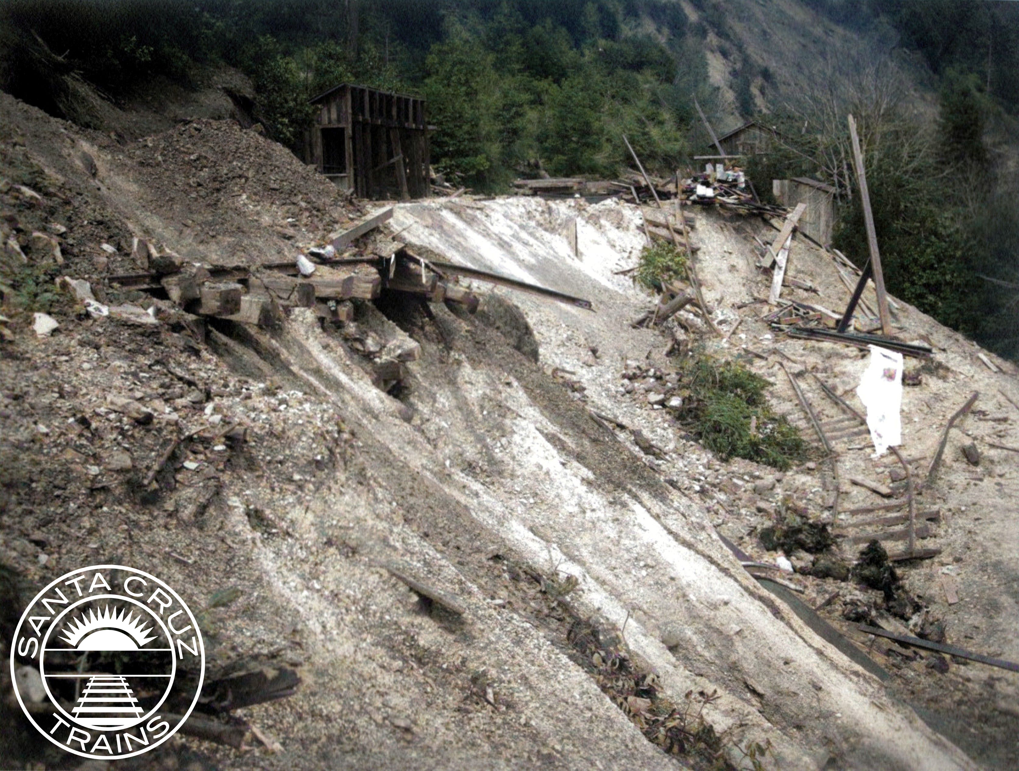
After long discussions and public debates, Southern Pacific decided to abandon 17 miles of track between Los Gatos and Eccles, north of Felton. It would operate the two lines separately. All of the track and infrastructure worth salvaging was removed in 1941 and 1942, and then three of the tunnels were dynamited by the Army Corps of Engineers around late April 1942. Whereas earlier storms had led to buy-outs, reincorporations, and abandonments of short segments of track, this storm led to the end of a 60-year-old railroad route. It also marked the end of regular railroad passenger service in Santa Cruz County, since all earlier passenger lines had already converted to autobuses.

Collapsed Soquel Avenue bridge over the San Lorenzo River, January 1982. [Courtesy Gary Griggs, Santa Cruz Sentinel]

The Storm of 1982

One final line in Santa Cruz County was abandoned because of a storm. Over the winter of 1981-1982, constant heavy rains pounded Santa Cruz County, inundating the soil and causing slides and sinks across the northernmost 8.8 miles of the Santa Cruz Branch between Santa Cruz and the former Eccles station. This section had been retained by Southern Pacific because of the two sand quarries located in the Olympia area above Zayante Creek, but by 1981 the company had increased prices such that the remaining company decided to shift to trucks for freight. Southern Pacific was likely to abandon this section anyway, since it was expensive to maintain, but the storm made the decision easier. With so much damage on a line that paid almost nothing, Southern Pacific finally had the excuse it needed to abandon this 107-year-old railroad line. F. Norman Clark had a different idea, though.

The owner of the Roaring Camp & Big Trees Narrow Gauge Railroad, Clark saw the potential of the standard-gauge railroad line to Santa Cruz and offered to buy it from Southern Pacific. He knew that acquiring the line would mean his small amusement park would become a common carrier for San Lorenzo Lumber, other local businesses, and any future quarry traffic. He also knew that his company would be responsible for any annual damage to the line. Despite all of this, he decided to buy anyway. On August 12, 1985, Clark incorporated the Santa Cruz Big Trees & Pacific Railway and purchased the line. It has been running between Felton and Santa Cruz almost continuously ever since as the Beach Train.

Undermined tracks beside Gallighan Slough outside Watsonville, 2017. [Courtesy Ben Rylander]

The Storm of 2017

Even in more recent times, storms continue to impact local railroading. Besides annual maintenance required along the Beach Train’s line, the Santa Cruz Branch Rail Line, now routed from Pajaro to Davenport, has required constant repairs. Between 1996 and 2012, this was done by the Union Pacific Railroad, but in more recent years it has been the responsibility of common carriers acting on behalf of the Santa Cruz County Regional Transportation Commission, which now owns the line in trust for the people of Santa Cruz County.

Overgrown tracks and mud at the washout, October 2017. [Courtesy Derek Whaley]

Iowa Pacific Holdings, operating as the Santa Cruz & Monterey Bay Railway, was the first firm to take responsibility for local lines. However, in early 2017, winter storms undercut the right-of-way beside Gallighan Slough outside Watsonville rendering the entire line beyond that point unusable. Storm water from adjacent agricultural fields was allowed to drain into the right-of-way, which had no drainage system to address this issue, so the result was undermining of the tracks. The storm damage and repair quickly became a political talking point, delaying repairs for over two years. Iowa Pacific pulled out of its contract and Progressive Rail, operating as the St. Paul & Pacific Railway, took over.

Crews cutting down a fallen tree on the Santa Cruz Branch Rail Line, June 2017. [Courtesy Howard Cohen]

Due to all of these delays, other portions of the right-of-way have since fallen into disrepair, including multiple large bridges that have been condemned, a perpetually flooded right-of-way near Wilder Ranch, and a migratory sand dune south of Davenport that has entirely consumed the railroad tracks. Roaring Camp Railroads now operates trains along the line on behalf of St. Paul & Pacific, but when rail traffic beyond Ellicott can resume remains an open question. In the meantime, freight traffic remains restricted to the first few miles of track from Pajaro, while separate traffic can hypothetically operate between Olympia, Wilder, Santa Cruz, and Capitola.

Citations & Credits:

  • Hamman, Rick. California Central Coast Railways, second edition. Santa Cruz, CA: Otter B Books, 2007.
  • Powell, Ronald G. The Reign of the Lumber Barons: Part Two of the History of Rancho Soquel Augmentation. Santa Cruz, CA: Zayante Publishing, 2021.
  • Santa Cruz Evening News, Sentinel, and Surf. Various articles.