
Showing posts with label natural disasters. Show all posts

Thursday, February 2, 2023

Curiosities: Storms and the Railroads

The watersheds of the Santa Cruz Mountains and Monterey Bay have never been kind to the region’s railroad infrastructure. From the earliest days of local railroading, landslides, sinks, cave-ins, and flooding have been commonplace, rendering various regional branch lines out of commission for months while bridges, tunnels, and rights-of-way are repaired. Because winter storms in particular have historically been so destructive, it is not surprising that some of these have been photographed by the railroad companies and interested parties. However, many storms have gone little recorded and unphotographed. making the creation of a full history of storm damage to local railroad lines nearly impossible.
A major washout at Edric near the southern (railroad east) portal of the Summit Tunnel, 1909. [Courtesy Neil Vodden Collection, courtesy Jack Hanson – colorized using MyHeritage]

As with similar blog posts of this nature, this article will evolve over time as more information and photographs come to light. If you know of any storms that significantly impacted local railroads not recorded below, or have photographs of any local railroad infrastructure damage from storms, please share your information on Facebook in the Santa Cruz Trains group.

The Storms of 1875-1876

Not long after the Santa Cruz & Felton Railroad opened in 1875, a winter storm threw a section of track south of Felton below Inspiration Point into the San Lorenzo River far below. This became an annual occurrence and the short line railroad did not have the funds to finance a more formal fix to the situation. Each year, the company just cleared slides and repaired damage right-of-way along the stretch of track known as Coon Gulch, and then resumed operations.

When the South Pacific Coast Railroad took control of the right-of-way in 1879, it attempted to remedy the worst of the problems. It reinforced the hillside trestles along the gulch and built a tunnel underneath Inspiration Point to avoid an especially sharp turn around a rock outcropping that was prone to rockslides. Yet these did not stop the problem—they only made the problem easier to repair. Each year, more rocks would fall on the tracks and the Southern Pacific Railroad (after 1887) gradually extended a shed over the tracks to protect them from these falls. Meanwhile, the largest of the hillside trestles was eventually replaced in March 1905 with a beautiful concrete arch bridge, which has since been the subject of many photographs since it can be viewed from Inspiration Point. Even these adaptations, though, only lessened the financial impact of slides; they did little to stop them from happening. Today, Roaring Camp Railroads clears slide activity along this stretch regularly after even the mildest storm or windy day.

One other result of the storms of 1875-1876 was the destruction of the Santa Clara Valley Railroad between Alviso and Dumbarton Point. This line was incorporated to build a railroad from Oakland to Santa Cruz via a route through the Santa Cruz Mountains. Its destruction in the storm led to its reincorporation as the South Pacific Coast Railroad in May 1876 with new financial backing but a similar proposed route.

The Storm of 1881

Storms did have a habit of undermining the short-line railroads of the region. An aggressive January storm in 1881 went so far as to wash out large portions of the Santa Cruz Railroad line, which had experienced annual storm damage since it had first opened less than five years earlier. By January 1881, the company was running on fumes with much of its revenue lost to the South Pacific Coast Railroad, which had a more direct route to the Bay Area. On January 27, the railroad bridge at the mouth of the San Lorenzo River was completely destroyed. The cost to repair the bridge and the rest of the line was too much, so the company fell into receivership. Not long afterwards, it was purchased by the Southern Pacific Railroad in a bankruptcy auction. While the line was rebuilt, it was now a wholly-owned subsidiary of Southern Pacific.

Collapsed trestlework at the approach to the San Lorenzo River bridge in Santa Cruz, January 1890. [Courtesy University of California, Santa Cruz, Digital Collections – colorized using MyHeritage]

The Storms of 1889–1890

December 1889 was an exceptionally wet month across California that saw damage to nearly every railroad line in the state. Slides and fallen trees were the main hazard to the railroad and shut the route through the mountains and to Boulder Creek down on multiple occasions. As had become a trend, the steep hillside below Highway 9 and south of the Inspiration Point Tunnel (Tunnel No. 6, later No. 5) collapsed. Other slides happened near the Powder Works station and south of Glenwood above Bean Creek. The entire Boulder Creek Branch was out of commission, with slides most likely happening in the vicinity of Brackney, where the hillside was steepest.

Another major storm struck in late January 1890 which caused far more destruction than the first. All of Front Street in Santa Cruz was under water on January 25, but more troubling was that the railroad bridge over the San Lorenzo River at the beach had fallen off its foundations. A logjam piled up under the bridge, putting immense pressure on its piers. Crews spent the week after the storm repairing the bridge and also clearing several slides and sinks from across the route to Watsonville. The station in Watsonville, meanwhile, was under water. Elsewhere in the county, the bridge over Newell Creek on the Boulder Creek Branch was heavily damaged, though still in place, and the long bridge over Zayante Creek near today’s Mount Hermon was in a similar condition.

By the end of the 1889-1890 rainy season, over 124 inches of water had fallen in the Santa Cruz Mountains. The damage was so widespread across the region’s railroad lines that the Santa Cruz Surf speculated it may be easier to grade entirely new routes than restore caved-in cuts and repair sinks, especially south of Felton. Damage to the northern end of the route between Oakland and San Jose was also immense, with much of the trackage flooded around Alviso.

Reconstruction of the west portal of the Summit Tunnel, 1893. [Colorized using MyHeritage]

The Storm of January 1893

The year 1893 was ushered in by yet another monstrous storm. In addition to widespread damage throughout the Santa Cruz Mountains, the main casualty of the tempest was the northern (railroad west) entrance of the Summit Tunnel (Tunnel No. 2, later No. 1) at Wright’s Station. About 100 feet inside the portal, a complete cave-in occurred that resulted in a total reconstruction of that end of the tunnel. In the meantime, the Southern Pacific Railroad’s mountain route was closed and all traffic diverted through Watsonville. The new tunnel that was constructed was made of concrete in an oval shape with a concrete channel beside it to divert run-off from the hillside above.

Reconstruction of the Summit Tunnel nearing completion, Spring 1893. [Colorized using MyHeritage]

One benefit of this reconstruction was that the tunnel was built to standard-gauge scale, meaning it did not have to be rebuilt when the line was standard-gauged from 1906-1909. It also was of sufficient quality that it suffered only minor damage in the 1906 San Francisco Earthquake. However, a downside is that it was also built of slightly inferior materials, so when the tunnels were dynamited in 1942, the portal at Wrights exploded, whereas the other seven abandoned portals have survived to the present.

The Storm of 1899

While the Loma Prieta Branch north of Aptos was always an industrial line focused exclusively on logging, it did offer some passenger and excursion services on request and the occasional alternative freight was shipped on the route. Nonetheless, it was a storm in March 1899 that cut the life of the line short. Logging north of the village of Loma Prieta had been on the decline for a few years when the mid-March storm struck. The initial damage to the route was focused in the vicinity of Hell’s Gate, an especially narrow section of Aptos Creek on the road to Monte Vista near Five Finger Falls. While slides along this stretch were not uncommon, the ones in 1899 were severe. Initial reports suggested that the line would be shut down and Monte Vista abandoned, but that wasn’t strictly true. Southern Pacific did, in fact, repair the line and continued to harvest timber beyond it for the next three summers. But the cost of restoring the line to full operations likely convinced the railroad company to downgrade it and wrap up operations north of Hell’s Gate. The passenger station at Monte Vista closed in November 1899, and the route to Monte Vista was abandoned on June 30, 1902.

A temporary trestle installed south of Rincon above the San Lorenzo River, 1909. This has since become a permanent raised section of track. [Neil Vodden Collection, courtesy Jack Hanson – colorized using MyHeritage]

The Storm of 1909

The 1906 San Francisco Earthquake did a number on all of the region’s railroad lines, knocking the route through the mountains completely out of commission in the process. Rather than repair and reopen, Southern Pacific decided to keep the line closed until all of the tracks could be upgraded to standard gauge. This meant enlarging all six remaining tunnels along the mountain route and rebuilding or expanding many bridges. Most of this work was completed by early 1909 when a sudden storm swept through the Bay Area on January 20.

Receding floodwaters beside the Southern Pacific track at Ellicott, 1909. [Neil Vodden Collection, courtesy Jack Hanson – colorized using MyHeritage]

The next day, Santa Cruz County was struck by the storm and the Pajaro Valley flooded. Traffic between Santa Cruz and Watsonville was cut, while traffic along the Boulder Creek Branch was also paused due to slides. At Laguna (Nuga), railroad crews dumped hundreds of carloads of ballast into Watsonville Slough in an attempt to stabilize the right-of-way, but most of it washed away soon after being dumped. In the fruit-packing district along Walker Street, the tracks were undermined and washed away. Meanwhile, the main road and railroad between Alma and Wrights at Eva washed out, cutting railroad service between Los Gatos and Laurel. It was only after repairs to the line were made that Southern Pacific was able to finally reopen the full mountain route following three years of closure.

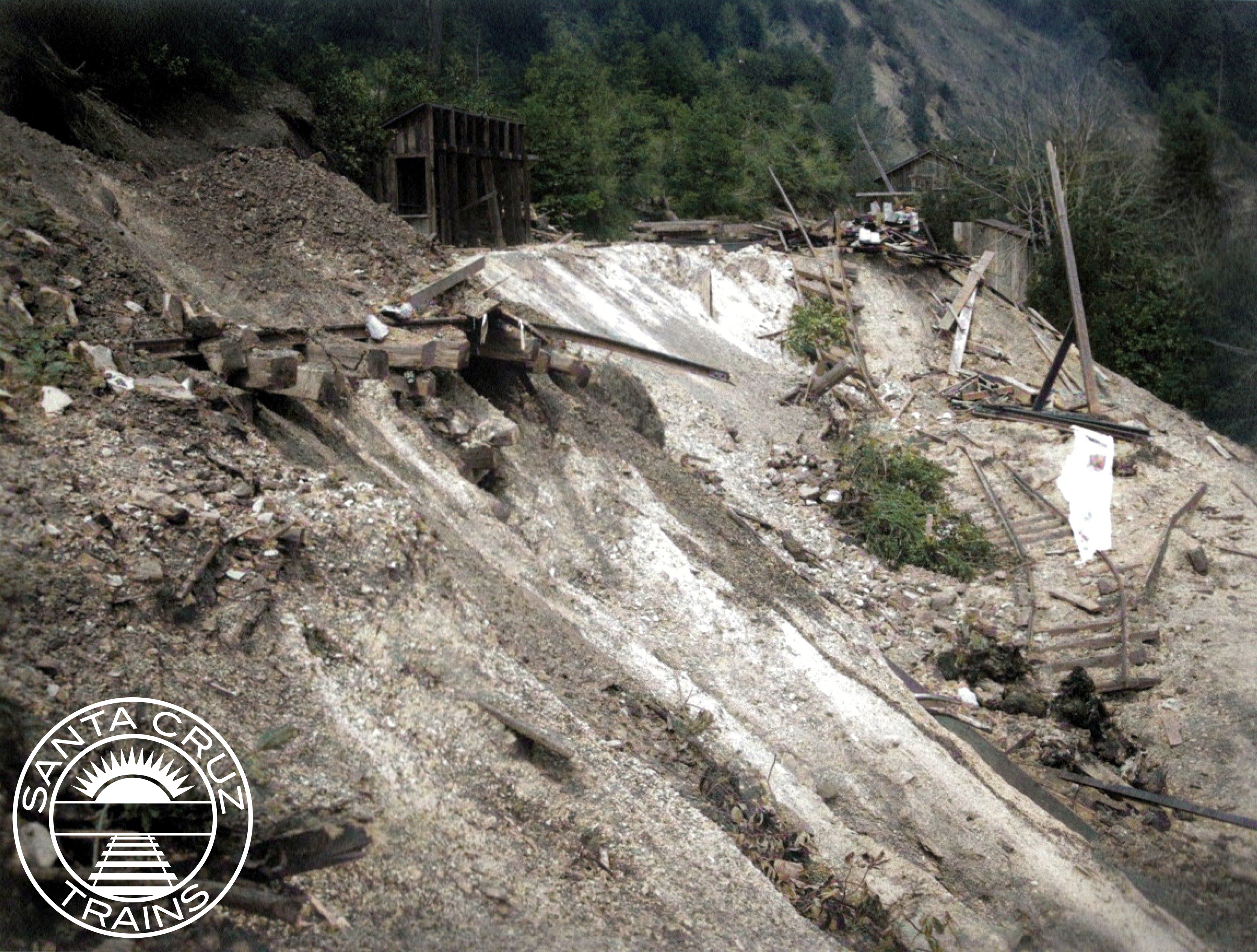
Landslide covering the tracks across from the east portal of the Summit Tunnel, February 29, 1940. [Courtesy Bruce MacGregor – colorized using MyHeritage]

The Storm of 1940

Jumping ahead several decades, the storm of the night of February 26, 1940, was the most catastrophic to local railroading. Over one night, such extreme damage from weather impacted the railroad route through the Santa Cruz Mountains that Southern Pacific estimated it would cost $46,220 ($966,180 today) to repair. The company’s usual annual cost of maintaining the right-of-way between Los Gatos and Felton was already the relatively high amount of $25,000 ($522,600 today) for about 20 miles of track. Thus, one storm incurred almost double the cost of annual repairs of the line. Only three years earlier, Southern Pacific had spent a considerable sum upgrading track, smoothing curves, reinforcing retaining walls, and making other repairs to the line to ensure its long-term feasibility. Yet none of that mattered in the face of a powerful storm.

Shifting ground across from the water tower at Tank Siding, March 1, 1940. [Courtesy Bruce MacGregor – colorized using MyHeritage]

After long discussions and public debates, Southern Pacific decided to abandon 17 miles of track between Los Gatos and Eccles, north of Felton. It would operate the two lines separately. All of the track and infrastructure worth salvaging was removed in 1941 and 1942, and then three of the tunnels were dynamited by the Army Corps of Engineers around late April 1942. Whereas earlier storms had led to buy-outs, reincorporations, and abandonments of short segments of track, this storm led to the end of a 60-year-old railroad route. It also marked the end of regular railroad passenger service in Santa Cruz County, since all earlier passenger lines had already converted to autobuses.

Collapsed Soquel Avenue bridge over the San Lorenzo River, January 1982. [Courtesy Gary Griggs, Santa Cruz Sentinel]

The Storm of 1982

One final line in Santa Cruz County was abandoned because of a storm. Over the winter of 1981-1982, constant heavy rains pounded Santa Cruz County, inundating the soil and causing slides and sinks across the northernmost 8.8 miles of the Santa Cruz Branch between Santa Cruz and the former Eccles station. This section had been retained by Southern Pacific because of the two sand quarries located in the Olympia area above Zayante Creek, but by 1981 the company had increased prices such that the remaining company decided to shift to trucks for freight. Southern Pacific was likely to abandon this section anyway, since it was expensive to maintain, but the storm made the decision easier. With so much damage on a line that paid almost nothing, Southern Pacific finally had the excuse it needed to abandon this 107-year-old railroad line. F. Norman Clark had a different idea, though.

The owner of the Roaring Camp & Big Trees Narrow Gauge Railroad, Clark saw the potential of the standard-gauge railroad line to Santa Cruz and offered to buy it from Southern Pacific. He knew that acquiring the line would mean his small amusement park would become a common carrier for San Lorenzo Lumber, other local businesses, and any future quarry traffic. He also knew that his company would be responsible for any annual damage to the line. Despite all of this, he decided to buy anyway. On August 12, 1985, Clark incorporated the Santa Cruz Big Trees & Pacific Railway and purchased the line. It has been running between Felton and Santa Cruz almost continuously ever since as the Beach Train.

Undermined tracks beside Gallighan Slough outside Watsonville, 2017. [Courtesy Ben Rylander]

The Storm of 2017

Even in more recent times, storms continue to impact local railroading. Besides annual maintenance required along the Beach Train’s line, the Santa Cruz Branch Rail Line, now routed from Pajaro to Davenport, has required constant repairs. Between 1996 and 2012, this was done by the Union Pacific Railroad, but in more recent years it has been the responsibility of common carriers acting on behalf of the Santa Cruz County Regional Transportation Commission, which now owns the line in trust for the people of Santa Cruz County.

Overgrown tracks and mud at the washout, October 2017. [Courtesy Derek Whaley]

Iowa Pacific Holdings, operating as the Santa Cruz & Monterey Bay Railway, was the first firm to take responsibility for local lines. However, in early 2017, winter storms undercut the right-of-way beside Gallighan Slough outside Watsonville rendering the entire line beyond that point unusable. Storm water from adjacent agricultural fields was allowed to drain into the right-of-way, which had no drainage system to address this issue, so the result was undermining of the tracks. The storm damage and repair quickly became a political talking point, delaying repairs for over two years. Iowa Pacific pulled out of its contract and Progressive Rail, operating as the St. Paul & Pacific Railway, took over.

Crews cutting down a fallen tree on the Santa Cruz Branch Rail Line, June 2017. [Courtesy Howard Cohen]

Due to all of these delays, other portions of the right-of-way have since fallen into disrepair, including multiple large bridges that have been condemned, a perpetually flooded right-of-way near Wilder Ranch, and a migratory sand dune south of Davenport that has entirely consumed the railroad tracks. Roaring Camp Railroads now operates trains along the line on behalf of St. Paul & Pacific, but when rail traffic beyond Ellicott can resume remains an open question. In the meantime, freight traffic remains restricted to the first few miles of track from Pajaro, while separate traffic can hypothetically operate between Olympia, Wilder, Santa Cruz, and Capitola.

Citations & Credits:

  • Hamman, Rick. California Central Coast Railways, second edition. Santa Cruz, CA: Otter B Books, 2007.
  • Powell, Ronald G. The Reign of the Lumber Barons: Part Two of the History of Rancho Soquel Augmentation. Santa Cruz, CA: Zayante Publishing, 2021.
  • Santa Cruz Evening News, Sentinel, and Surf. Various articles.

Thursday, November 26, 2020

Events: The Earthquake of April 18, 1906

On the evening of April 17, 1906, the Central Coast of California was on the brink of big changes for local railroads. After nearly twenty years, the Southern Pacific Railroad was finally upgrading its narrow-gauge route along the old South Pacific Coast Railway line from Alameda Point to Santa Cruz. Meanwhile, the Loma Prieta Lumber Company's mill in the Hinckley Basin off Soquel Creek had just started up again for a new season and the F. A. Hihn mill at Laurel was revving up for its fifth full season. Along the North Coast, the Ocean Shore Railway had just reached Davenport where the Santa Cruz Portland Cement Company was busy building its new refinery, while the Coast Line Railroad, owned by Southern Pacific, was lagging behind with its tracks through the West Side still under construction. Southern Pacific crews elsewhere in the county had recently finished a substantial survey for a route north of Boulder Creek into the Pescadero Creek basin, where they hoped to build a new connecting loop line that would eventually wrap back south to Davenport and allow access to millions of board feet of lumber in the Pescadero valley. The Ocean Shore was also interested in such a loop route, as well as an electric streetcar line into Big Basin. At around the same time, the Western Shore Lumber Company, owned by Loma Prieta Lumber Company executives, was founded to harvest these tracts as soon as possible. The vision for local railroading ventures was boundless.

A stretch of three-rail track displaced by the earthquake above Los Gatos Creek near Wrights, 1906. [Bancroft Library – colorized using DeOldify]
Earthquakes were not a new phenomenon in California—the indigenous Awaswas people were keenly familiar with them and even the earliest Spanish settlers experienced them somewhat frequently. Every generation of Californian eventually came to terms with the fact that the San Andreas Fault was more unpredictable and temperamental than your average fault line. But the temblor that struck the Bay Area on the morning of April 18, 1906, was unlike any the state had felt since it became a United States possession. Most of the Central Coast was still either sleeping or just emerging from rest when it struck. Railroad workers were just beginning their morning shifts, with construction crews preparing to toss off the third rail between San José and Los Gatos, their work of upgrading the line nearly complete. People in the mountains were lighting fireplaces and stoves for their morning coffee and tea. Mill donkey engines were warming up, too, preparing for a long day of sawing cut logs into lumber. None of them anticipated the destruction that would violently interrupt their peace and destroy all plans for the foreseeable future.

An Ocean Shore Railway train assisting in clearing debris from the ruins of San Francisco, 1906. [Bancroft Library – colorized using DeOldify]
The sun was only minutes from rising over the distant Sierra Nevada at 5:12 a.m. when the world first shifted. Frederick A. Hihn, who was staying at the Palace Hotel in San Francisco that day, recounted:
I felt the earthquake coming—much harder than I had ever experienced. The plaster from all around the sides of the room fell in large pieces, while in the middle of the room where my bed was, only sand and dust came down. The quake seemed to continue more than five minutes though it really lasted less than two minutes. It seemed to try its best to shake me out of bed, but I succeeded in staying in. As soon as it subsided I arose and turned on the electric light. Its unsteadiness proved there was an interference which indicated danger to the house being set afire.

He was right to fear the unsteady flames of his lamp—much of San Francisco would burn over the next week due to broken gas lines and open flames causing an inferno through the heart of downtown. The palatial mansions of the Big Four on Nob Hill were among the victims of the fires as were the corporate offices of the Ocean Shore Railway and some of the offices of the Southern Pacific. Over 80% of the city was damaged or destroyed in the temblor and inferno.

A displaced fence caused by a rift through a person's property near Wrights, 1906. [Bancroft Library – colorized using DeOldify]

The earthquake hit in waves, with an initial rumble at 5:12 that woke up much of the Bay Area, and a more severe blast about 30 seconds later, that would later be estimated at about 7.9 on the Richter scale. It was the single greatest earthquake in the recorded history of the West Coast. As few as 700 and as many as several thousand people perished in the quake and ensuing fires, making it also the deadliest natural disaster in California. Aftershocks continued for weeks, causing mayhem and straining nerves. The dispersion of energy from the fault led to earthquakes elsewhere in the state, as well, as far south as the Imperial Valley and as far north as Eureka, where a 6.7 magnitude earthquake struck on April 23. Nobody in California rested easy in the month after April 18, 1906.

Twisted rails caused by the earthquake along the viaduct at Moss Landing, 1906. [Bancroft Library – colorized using DeOldify]

Further south, outside Los Gatos at a station named Bermingham, the powder warehouse for the New Almaden quicksilver mines, operated by the California Powder Works, erupted in a massive explosion, although it appears nobody was killed in the incident. Throughout the Bay Area, including along Los Gatos Creek and as far south as the Pajaro Valley Consolidated Railroad's track at Moss Landing, rails were twisted and grades shifted. Even the course of the Salinas River moved from Elkhorn Slough to an old channel northeast of Marina. In truth, the integrity of the entire network of rails that spanned the Central Coast was questioned with surveyors needed to verify that trackage was still stable and reliable. In many places, it was not and required sometimes substantial repairs before rolling stock could pass over it again. For example, the Southern Pacific bridge over the Pajaro River south of Chittenden shifted over three feet off its piers, ultimately destabilizing the bridge. The bridge spanned the San Andreas Fault.

Cracked piers under the Pajaro River bridge near Chittenden, with temporary trestling to maintain the integrity of the span, 1906. [Bancroft Library – colorized using DeOldify]

Overall, the damage in Santa Cruz County was substantially less than in San Francisco, largely because no fires swept through the cities and towns. After Hihn returned from San Francisco he recounted his observations:

At Watsonville I found the damage by the earthquake light comparative to San Francisco and San Jose. There I took another team which brought me to Santa Cruz about five o’clock where I was received with great pleasure by many of my friends and family, who had feared I was lost.

The loss by earthquake at Santa Cruz is comparatively light. Our office building suffered perhaps the most although it was the strongest building. The Court house seems to have been considerably injured and a few other places.
Wreckage at the site of the Hinckley mill, 1906. [Popular Science Monthly]

Eleven people died in the county as a direct result of the earthquake, all but two of whom were killed in a massive landslide that completely buried the Loma Prieta mill on Hinckley Gulch. The Surf reported:

Here both sides of the canyon walls appeared to crush together and a mass of earth estimated at a hundred feet in depth filled the canyon, crushing in and burying the workmen who were living in cabins at work on the new mill

Mill, buildings and road were all submerged. Mr. Williams, the resident representative of the company, sent doctors to the scene, and dispatched laborers by the wagonload as fast as they could be obtained, but on arrival at the scene it was found impossible to reach the men or to make much progress in rescue work. The stream is completely choked by the debris, and the impounded water will form a menace to all the valley below.

The entombed men, as far as known, are believed to be Foreman [James] Walker; J. O. Dunham (the engineer); H. E. Estrada; Alex Morrison; Gus Vollandt; Frank Jones; Fred Peaslee; A. Buckley; and Charley June (the Chinese cook).

Part of the landslide that cost the lives of nine millworkers on Hinckley Creek, 1906. [Popular Science Monthly]

David Starr Jordan, president of Stanford University, added that the "mill was completely buried, with nine mill hands, and a redwood tree over a hundred feet high was set erect and unhurt over the place where the mill stood. The bodies of six men were recovered. One of these, the foreman, was found erect, smothered in mud, standing with extended arms and limbs in the act of running from the mill. With him, equally erect and in the act of running, was the body of a Siberian mastiff." The other two deaths in the county were two men who were caught in a similar slide at the Hartman and McNabb mill on Deer Creek north of Boulder Creek.

The slide on Deer Creek that cost the lives of two millworkers, 1906. [Bancroft Library – colorized using DeOldify]

Jordan wrote a detailed forensic analysis of the earthquake's geomorphic impact to the Monterey Bay, explaining:

The crack went on across the hills, always in the same direction, southeast by south, till it came to the Chittenden Ranch in the Pájaro Valley. Here it tore off the hillside, destroying the highway at its base; then descended to the Pájaro River, shifting a pier of its railroad bridge about eighteen inches to the northwest. Here it met the Pájaro cross-fault. But here the straight line from Point Arena came to an end. A series of short breaks creeps off to the southeast, ending two miles southwest of San Juan, the last act being the final, almost complete, wreck of the beautiful and venerable Mission of San Juan Bautista.

Rift through the road caused by the earthquake at the entrance to Watsonville's Chinatown, 1906. [Pajaro Valley Historical Association]

A letter by a member of Hihn's staff, dated the day after the quake, gave more particulars regarding damage to downtown Santa Cruz and to the operations of the Hihn company:

Very heavy earthquake here. Court House badly damaged. Office building [of F. A. Hihn] — rear wall down above second story and side walls cracked. Other buildings of the Company were on lines injured. Two thirds of the chimneys in the entire town off. Might have been worse but bad enough. We suppose you have received reports from the Hinckley Mill. Nine lives being lost and two at Boulder Creek.

Watsonville badly shaken. San Jose, several buildings down. San Francisco reports the earthquake did not do much damage but the fire has burned from the Ferry to Seventeenth Street and Larkin Valley. Lick House reported burnt so the fire must have crossed Market as the report also says Battery Street building is on fire.

Fix up the water works first and clear creek of lumber. Do not think advisable to do more than necessary to place things in order until Mr. F. A. Hihn returns. Have sent four different parties to San Francisco but have not been able to receive any information in regard to Mr. Hihn. Party reports leaving Palace at 9 o’clock after earthquake and the Palace Hotel not injured a great deal, thus was greatly relieved in regard to Mr. Hihn being injured.

Can order meat sent to Glenwood if advisable. Think advisable not to build fire under boilers or run any portion of the Mill until F. A. Hihn returns as every portion should be inspected. Think advisable to stop all other operation to skid road and other work until we secure some information in regard to time it will take to clear tunnels for operation.

Instruct all tenants not to build fires in chimneys where broken below the roof. Do not delay in fixing water mains.
The shifted wall within the Summit Tunnel, the town of Wrights visible through the portal at right, 1906. [Bancroft Library – colorized using DeOldify] 
In the end, much of the damage around the Monterey Bay and in the Santa Cruz Mountains was relatively easy to repair. The biggest problem, however, was the damage to the Southern Pacific route through the Santa Cruz Mountains. Besides small landslides, sinks, washouts, shifts in the grade, and twisted rails, the route had suffered a monumental blow to the Summit Tunnel, which experienced an internal lateral shift of five feet at about 400 feet inside from the Wright's side. In the weeks after the quake, Southern Pacific Engineer Everett P. Carey assessed the tunnel, concluding:
The damage to the tunnel itself consisted in the caving in of overhead rock; the crushing in toward the center of the tunnel of the lateral upright timbers, and the heaving upward of the rails, due to the upward displacement of the underlying ties. In some instances, these ties were broken in the middle. In general the top of the tunnel was carried both north or northwest with reference to the bottom.
This should have been predicted—the San Andreas Fault passed directly through the tunnel on its northern side and a coal vein linked to this fault line had released methane and oil into the tunnel in 1879, prompting a deadly explosion. Repairs after a massive landslide in 1893 had led to the upgrading of the portal on the Wright's side, which also addressed more definitively the methane leak but not the potential problem of the fault line, which engineers had positively identified as such as early as the 1880s.

Work crews inside the Summit Tunnel, ca 1907. [Derek Whaley – colorized using DeOldify]
With the Summit Tunnel out of commission, work on standard-gauging the line came to a halt, as did all traffic along the line. Any railroad traffic into Santa Cruz would have to go via Pajaro once those tracks were repaired. Indeed, for several days, Santa Cruz County was almost entirely cut off from the outside world, with telegraph and telephone wires severed and transportation difficult across ruined bridges and suddenly uneven roads. The Laurel-Glenwood Tunnel and the smaller tunnels along the southern portion of the mountain line mostly survived the quake and were back in working order within weeks. As a result, Hihn opened up a shingle mill at Laurel to cut crossties, bents, and posts to repair the railroad lines, while he relocated the rest of the mill's machinery to King's Creek north of Boulder Creek, where he produced lumber for the rebuilding of downtown Santa Cruz, San Francisco, and the other more severely hit Bay Area towns.

Derailed fruit boxcars that were awaiting shipment at Chittenden, 1906. [Graniterock – colorized using DeOldify]
The Railroad Wharf, which had only occasionally been used for the past decade, once more became a primary means of shipping goods and steamships called in regularly in the months after the quake to collect lumber, lime, and blasting powder, and other products for use in San Francisco and elsewhere. Meanwhile, the mountain tracks remained narrow-gauge and would continue to be so for the foreseeable future until the tunnels and existing infrastructure were repaired. Much of the old rolling stock had already been sold, meaning that operations relied heavily on California Timber Company stock and locomotives and other long-outdated machinery.

Closeup of the temporary trestlework done to the Pajaro River bridge near Chittenden to reinforce the structure, 1906. [Bancroft Library – colorized using DeOldify]
Relying on old machinery and obsolete track gauges meant that Southern Pacific had to work fast to restore access to Santa Cruz County. The Pajaro River bridge was restored to functionality via a complex wooden trestle frame installed around the collapsed piers. The remainder of the coastal route was repaired over late spring and operating again by summer. The next step was to standard-gauge the track from Santa Cruz to Boulder Creek to facilitate the easy transfer of lumber between the two points. Unfortunately, this required replacing the bridge over the San Lorenzo River south of Felton and several other bridges on the way to Boulder Creek. The tight curves along San Lorenzo Gorge, as well as the tunnels, delayed progress more since the curves had to be lessened and the tunnel enlarged. The route only opened to standard-gauge traffic in June 1907, although narrow-gauge tracks still existed to Old Felton, from the Newell Creek Mill, and along the Dougherty Extension.

Repair camp at Wrights outside the Summit Tunnel, February 22, 1907. Photograph by Frank Herman Mattern. [Greg De Santis – colorized using DeOldify]
Meanwhile, repairs to the narrow-gauge track from Felton to Laurel, including to the tunnels, was completed by July, allowing wood products produced in Laurel to get to market. In early 1907, Southern Pacific announced that it did not intend to reopen the mountain route at all until the route was broad-gauged, meaning that the line would remain out of commission for at least another year. In reality, it took over two years, largely because of the economic Panic of 1907, which was partially caused by the earthquake. Reconstruction efforts in San Francisco brought in millions of dollars of funds from the East Coast but this led to an imbalance in investing in the market. From January 1906 to July 1907, the stock market became increasingly unstable culminating in a crisis in October 1907. These financial issues caused Southern Pacific to become more cautious with its spending, in effect delaying the upgrading of the mountain route and shelving plans for a Pescadero route or an extension of the Coast Line.  The panic also led to the temporary closure of several mills due to a lack of funds for building projects and a surplus of building materials.

Washout out Ocean Shore Railway tracks at Devil's Slide, 1906. [Huntington Library – colorized using DeOldify]
Following a year of uncertainty and little progress, Southern Pacific resumed upgrading in late 1908. On the North Coast, the Coast Line to Davenport was completed and the Ocean Shore Railway, which had suffered heavy financial loses in the earthquake and the panic, resumed work on a line from its temporary terminus at Scott to Swanton, where it had received a contract from the San Vicente Lumber Company in 1908 to use its line to transport logs. At Wright, Laurel, and Glenwood, Italian, Greek, and Japanese workers were brought in to finish the standard-gauging of the mountain route and enlarge the four tunnels still in need of upgrading. On May 29, 1909, the route was finally opened to standard-gauge trains and the last physical impairment caused by the earthquake in Santa Cruz County was removed.

Destroyed crushing plant along the tracks at the Graniterock quarry at Logan, 1906. [Graniterock – colorized using DeOldify]
The earthquake, however, had a long shadow and its long-term impact on the people of Santa Cruz County was felt in several ways. The hit to the tourism industry in the San Lorenzo Valley was permanent. Places like the Hotel de Redwood near Laurel, the various Glenwood resorts, Brookdale, and even Big Trees suffered and never full recovered since people were more weary and also had less cash to spend on travel. By the time the economy had recovered, the Model T Ford had arrived and people decreasingly spent their entire summers in one place as they had prior to the earthquake. While Fred Swanton's Neptune Casino and Plunge at the Santa Cruz waterfront survived the earthquake, both burned down only two months later and the economic fallout from the Panic of 1907 was one of the primary reasons why Swanton became increasingly desperate from 1908 to turn a profit with his rebuilt Casino and Natatorium. 

Debris blocking the flow of Los Gatos Creek creating a pond beside the three-rail tracks of the Southern Pacific Railroad, 1906. [Derek Whaley – colorized using DeOldify]
Meanwhile, Southern Pacific shelving most of its ambitious plans for the region meant that all of the local lines were doomed to a slow abandonment once their principal industries closed down. Indeed, the need for lumber to rebuild San Francisco greatly expedited the timber harvesting efforts at the headwaters of Pescadero Creek, on Bear, Deer, Two Bar, and King's Creeks, in the Aptos and Soquel Creek basins, within Rancho San Vicente, and in the Newell Creek basin, leading to the decimation the county's remaining old-growth redwood by about 1920. With these sources of timber gone, branch lines began to shut down—the Newell Creek Branch in 1913, the Dougherty Extension in 1917, the Ocean Shore-San Vicente line in 1923, the Loma Prieta Branch in 1927, the Boulder Creek Branch in 1934, and the mountain section in 1940.

Hay barn and stable damaged by the earthquake at Scaroni's Ranch on the North Coast near Davenport, 1906. [Santa Cruz Museum of Art & History – colorized using DeOldify]
Lastly, the costs associated with recovering from the earthquake's damage to its lines around Devil's Slide near Pacifica, as well as from the fallout of the panic in 1907 and further damage caused by destructive storms in January 1909, led to the financial collapse of the Ocean Shore Railway by December 1909. In January 1911, a new company, the Ocean Shore Railroad, was formed to revive the dream, but its scope was narrower and its dreams more realistic. In the end, it too failed to connect with the northern line that abruptly stopped just south of Tunitas. The Coast Line, with no functional competition and a ready customer in the Santa Cruz Portland Cement Company at Davenport, abandoned its plans to continue the line north to San Francisco or even to Pescadero, permanently ending the dream of a railroad line along the North Coast.

The Santa Cruz County Court House (Cooper House) undergoing repairs following the earthquake, 1906. [UCSC Legacy Digital Collections – colorized using DeOldify]
There are moments in history when everything changes in a moment. For California, that moment was the San Francisco Earthquake. Even though the Central Coast quickly recovered and most of the quake's visible scars were wiped away through new construction and renewed economic activity, the delay of roughly five years of progress stripped San Francisco of its central position in California politics. During this time, San Pedro Harbor opened in Los Angeles, slowly displacing San Francisco as the state's primary industrial port. The film industry also settled in the Los Angeles basin rather than the Bay Area during this time, partially due to a lack of space and facilities caused by the lingering impact of the earthquake. And the expansion of the automobile meant that people could travel farther and control their destination more acutely, which led to the slow abandonment of many formerly-popular vacation spots along the Central Coast. While the earthquake alone did not cause the diminution of the Bay Area, its timing was poor and certainly eased the shifting of political power to the rapidly-developing south.

Citations & Credits:
  • Hamman, Rick. California Central Coast Railways. Second edition. Santa Cruz, CA: Otter B Books, 2007.
  • Hihn, Frederick A. Letter written by F. A. Hihn regarding the San Francisco earthquake and fire of Wednesday, April 18, 1906. Santa Cruz, CA: University of California, Santa Cruz, Library.
  • Jordan, David Starr. "The Earthquake Rift of 1906," Popular Science Monthly 69 (Oct. 1906).
  • Powell, Ronald G. The Shadow of Loma Prieta: Part Three of the History of Rancho Soquel Augmentation. Santa Cruz, CA: Zayante Publishing, forthcoming.
  • Whaley, Derek R. Santa Cruz Trains: Railroads of the Santa Cruz Mountains. Second edition. Santa Cruz, CA: Zayante Publishing, forthcoming.