
Showing posts with label Santa Cruz & College Park Branch. Show all posts

Thursday, August 11, 2022

Stations: Eva

One of the primary appeals of a railroad through the Santa Cruz Mountains was its picturesque nature. However, much of the route through which the South Pacific Coast Railroad passed in 1880 was less verdant than it is today. Logging along Los Gatos, Bean, and Zayante Creeks had largely deforested the areas. Nowhere was untouched and only the Welch’s Big Trees Grove near Felton and parts of San Lorenzo Gorge to the south retained a semblance of wilderness. Because of this and because the South Pacific Coast Railroad was focused primarily on expanding its lines, the company never established its own picnic stop in the mountains. But when the Southern Pacific Railroad took over in 1887, it found a ready picnic ground on the east bank of Los Gatos Creek at a place it christened Forest Grove.

Members of the Toro Club gathering at Forest Grove, November 4, 1894. [Colorized using MyHeritage]

What would become Forest Grove had probably existed as an informal stop since the arrival of the South Pacific Coast Railroad to the area in 1879. In the first Officers, Stations & Agencies book published by Southern Pacific following the acquisition of the South Pacific Coast Railroad in 1887, the location was named Casey’s. This likely derived from the South Pacific Coast Railroad’s former roadmaster and superintendent of bridges, Thomas Casey, who was responsible for maintaining the right-of-way between San José and Santa Cruz between December 1880 and June 1884. He had previously worked in the same role for the Central Pacific Railroad during the construction of the first transcontinental railroad in the late 1860s. In summer 1884, he was given the task of laying the track for the Felton & Pescadero Railroad to Boulder Creek. Casey was well-respected by his peers and known in settlements across the South Pacific Coast Railroad’s network. He fell ill in January 1886 and died November 4, 1888 in San Francisco.

San Francisco Examiner advertisement for Forest Grove, printed June 2, 1899.

The seventeen-acre rectangular property was mostly on the east bank of Los Gatos Creek just south of Hooker Creek and 5.8 miles south of Los Gatos. The railroad purchased the land from John Young McMillan and Dr. William S. McMurtry of the Los Gatos Manufacturing Company on June 15, 1878 under the condition that the right-of-way remains in continuous use and maintenance. Considering the location—1.6 miles north of Wrights and the Summit Tunnel—it seems likely that the station began life as a staging ground for construction and maintenance crews. After the line was completed in May 1880, Casey’s probably became a maintenance yard, which would explain why the property was so large and why it was named after the roadmaster, who would have operated out of the station to perform many of his duties in the mountains.
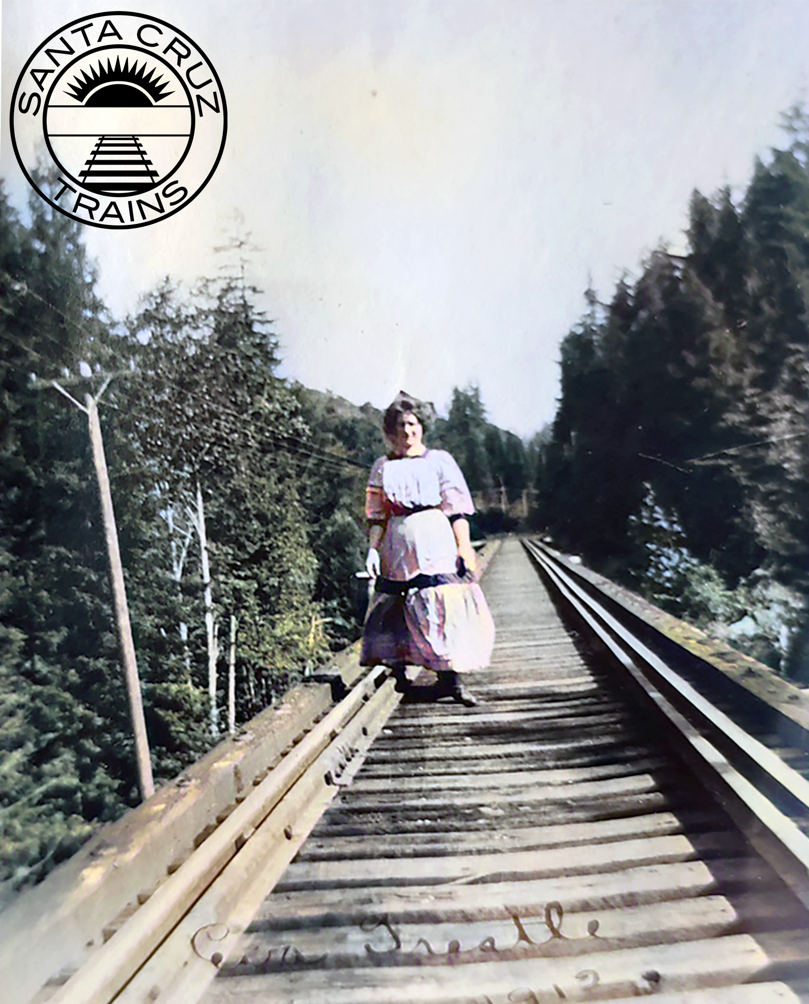
Woman on the Hooker Creek bridge north of Eva, 1912. [Ginger Constantine Navarrete – colorized using DeOldify]

Southern Pacific clearly had less interest in maintaining a remote maintenance yard, but it was looking for potential picnic stops in the mountains. Although the area around Hooker Creek had been logged over in the 1860s and early 1870s, second growth redwood trees were already appearing and the large meadow where the maintenance equipment had likely sat was ideal for a picnic ground. The railroad sent out W. T. Fitzgerald, general passenger and freight agent for the narrow-gauge division, to inspect the property and make sketches of it that could be used in marketing.

Members of the local Elks Lodge vacationing at Eva Vista, ca 1910. Printed in the Los Gatos Times–Saratoga Observer, July 23, 1974.

The picturesque station opened under the name Forest Grove on April 20, 1888, with a group of Presbyterians traveling from Brooklyn, New York, as its first visitors. The railroad provided picnic tables and accessories, and the people were responsible for bringing food. Though few amenities were provided to the revelers, they loved the place, noting that the “mountains covered with redwood forests, valleys and ravines in which marvelous ferns grow and wild flowers abound, and through which gurgling brooks flow in crystal streams, give abundant scope for romping and climbing by young America.” Over subsequent years, many different groups held annual picnics at Forest Grove, including the Knights of Pythias, the Native Sons of the Golden West, and Southern Pacific itself. The popularity of the picnic stop was such that in 1889, the Oakland Tribune declared it superior to Big Trees.

View of the resort looking south, with the Southern Pacific tracks to the left of the photographer and Los Gatos Creek to the right, ca 1909. Printed in the Los Gatos Times–Saratoga Observer, July 23, 1974.

Forest Grove continued to serve Southern Pacific as its chief picnic resort in the Santa Cruz Mountains until the end of the 1895 summer season. The next spring, the company opened Sunset Park south of Wrights and all picnic traffic was redirected there. For two years, Forest Grove seems to have languished, but in 1899 it was leased to Thomas M. Silvey of Wrights, who promoted fishing, hunting, and bathing in the San Francisco Examiner. In late 1889, W. R. Sterne of Los Angeles took over the lease and purchased the adjacent estate of the late Frederick A. Marriott, editor of the San Francisco News Letter tabloid.

Eva Vista Hotel beside the artificial lake and outbuildings, ca 1910. Printed in the Los Gatos Times–Saratoga Observer, July 23, 1974.

Sterne dammed Los Gatos Creek in order to create a small lake in which people could swim. He also began improving his newly-acquired property, erecting the Eva Vista Hotel up on the hill overlooking the lake and railroad tracks. The station, meanwhile, was renamed Eva to better promote the resort. Sterne never enjoyed the property, though. In May 1903, he sold the estate and the lease to H. R. Judah, assistant general passenger agent for the Southern Pacific. Judah soon erected a tent city and club house on the picnic grounds and expanded the hotel’s restaurant to support a larger crowd.

Postcard of Lake Evavista with an inset image of the cookhouse, 1910. [WorthPoint – colorized using DeOldify]

Unfortunately for Judah, his resort was not to last. When the San Francisco earthquake struck before the start of the 1906 season, it caused a landslide that blocked Los Gatos Creek causing it to overflow and flood the railroad tracks and much of the resort grounds at Eva Vista. Railroad traffic was canceled beyond Alba until August 1907, with only repair trains passing through to fix the right-of-way and widen the Summit Tunnel at Wrights. However, the flooded resort was only cleared in December, long after the picnic season had ended. The Panic of 1907 and the widening of the tunnel between Laurel and Glenwood in 1908 made the prospect of reopening Eva Vista infeasible.

San Francisco Chronicle advertisement for Evavista Resort, printed June 2, 1909.

When it finally welcomed visitors again in 1909, the resort was under the management of Peter Charles Trobock and his brother, Barton N. Trobock, who rebranded it Evavista. The resort’s ultimate fate three years later was outside anyone’s control. On August 27, 1912, mice nibbling on matches in the hotel started a fire. The structure burned to the ground, taking several nearby buildings with it. The last recorded picnic excursion to Evavista was on October 16, 1915 by juniors and seniors from Los Gatos High School.

Storm damage to the Southern Pacific right-of-way near Eva, 1909. [Neil Vodden – colorized using DeOldify]

The resort site quickly fell into disrepair but the railroad station remained on timetables for 25 more years. When the line was standard-gauged in 1905, a long siding measuring 2,340 feet—capable of holding 28 cars—was installed along the east side of the right-of-way. It broke off from the mainline just south of the Hooker Creek bridge and paralleled the main track for most of its length, reconnecting with the mainline just beyond the border of the rectangular parcel. A short spur continued from the end of the siding to allow up to three cars to park at the station without blocking the siding. The siding was cut back in late 1909 to 1,821 feet, enough space for about 22 cars.

Flatcars parked on the siding at Eva, 1909. [Neil Vodden – colorized using DeOldify]

The long siding may not have been intended just for passenger trains. During standard-gauging, Eva was likely used as a staging ground in the off-season for work crews. This was even more likely in the three years after the earthquake, where Eva probably served as a storage site for repair equipment and building supplies, considering the land to the east of the tracks remained Southern Pacific property. Meanwhile, in 1900, a vein of copper was discovered on the eastern hillside a mile south of Eva near the railroad right-of-way.

Southern Pacific locomotive and caboose parked on the siding at Eva, 1914. [Ginger Constantine Navarrete – colorized using DeOldify]

Perhaps because of the resort, no mining was performed until 1917, when an experimental adit was dug by H. E. Casey, J. E. Casey, and G. W. Stollery of San Mateo. The partners employed fifteen men for several months, who dug two tunnels, one 300 feet long and the other 185 feet. They found high concentrations of copper, and smaller veins of chalcopyrite, azurite, malachite, gold, and silver. However, due to poor market conditions and a lack of interest by potential buyers, they decided not to pursue further mining. The mines were sold to Dr. H. C. Adair in 1929, who promptly resumed prospecting. Four adits were dug into the hillside, with the largest supported by a timber frame. Large quantities of pyrite and other sulfides were discovered. A second attempt by Adair in 1936 found a quantity of gold and silver, resulting in the only profit gained from mining operations near Eva. The two longest tunnels, 235 and 500 feet in length, were abandoned in 1938. It is unclear if these operations used Eva station, but they are likely the reason why the railroad retained the station for so many years after the closure of the resort.

A Southern Pacific commuter train stopped at Eva, July 9, 1939. Photo by Wilbur C. Whittaker. [Jim Vail]

Eva Station was approved for abandonment on August 9, 1937 due to disuse, with Southern Pacific records showing it closed on October 15 of that year. It was removed from employee timetables in May 1939. The closure of the mountain route the following February put an end to any hope of rejuvenating the area around Eva. Following the legal abandonment of the line on March 25, 1941, the property reverted to its original owners, who had several years earlier sold the property to the San Jose Water Company. At the time, nobody lived in the vicinity of Eva to contest abandonment.

Southern Pacific survey photo of the Hooker Creek bridge just to the north of Eva, March 1940. [Bruce MacGregor]

Geo-Coordinates & Access Rights:

37.153˚N, 121.960˚W

The San Jose Water Company continues to own the land, though the right-of-way through the former site of Eva is so overgrown with poison oak and Scotch broom that it is virtually impassable. As a result, the company has not blocked access to this section of the grade, though trespassing is not advised for health and safety reasons.

Citations & Credits:

  • Bender, Henry, "SP22."
  • California Division of Mines, California Journal of Mines and Geology, 50 (January 1954).
  • California Journal of Mines and Geology 50 (January 1954).
  • California Public Utilities Commission, Decision No. 30018.
  • Hamilton, Fletcher. Report XVII of the State Mineralogist (San Francisco, CA: California State Mining Bureau, 1921).
  • Interstate Commerce Commission, Vol. 242.
  • Los Gatos Mail, 1915.
  • Oakland Tribune and Evening Tribune, 1884–1890.
  • Record-Union, 1888.
  • Sacramento Bee, 1882.
  • San Francisco Call, 1905.
  • San Francisco Examiner, 1899.
  • San Jose Daily Mercury, 1903.
  • San Jose Evening News, 1912.
  • Santa Cruz Sentinel, 1885–1903.
  • Southern Pacific Railroad Company, various records.
  • Whaley, Derek R. Santa Cruz Trains: Railroads of the Santa Cruz Mountains (Santa Cruz, CA: 2015).
  • Wiley, Marlene. “Riding the Picnic Trains,” Mountain Network News (date unknown).
  • Young, John V. Ghost Towns of the Santa Cruz Mountains, expanded edition (Santa Cruz, CA: Western Tanager Press, 1984).

Friday, August 21, 2020

Freight Stops: Cowell Spur

The history of the Henry Cowell Lime & Cement Company on the Santa Cruz Main Beach begins before California statehood. In 1849, early American settler Elihu Anthony erected a potato chute at the top of Bay Street in order to get his crops to passing ships quickly without the need for boats that had to fight heavy waves off the beach to get to waiting ships offshore. In the end, the chute was still impractical since the waves at the bottom of what would become Steamer Lane (named after the steamships that would later dock there) were often too violent. As a result, Anthony decided to expand the chute into a pier by making it longer and wider. The chute had been a steep decent to the bottom and the new pier was no different, but Anthony made this work. Anthony's business partner, Edward S. Penfield, built a large warehouse at the top of the pier to store goods awaiting shipment.

The Cowell Wharf at the end of Bay Street with the Railroad Wharf visible through the pilings, c 1890s.
[Santa Cruz Museum of Art & History – Colorized using DeOldify]
A great and permanent change overtook the pier around late 1853 when Isaac E. Davis and Albion P. Jordon began using it to ship lime products to market. Earlier that year, Davis and Jordan had opened a large limestone quarry at the top of Bay Street and the convenient location of the pier at the bottom of Bay Street could not be ignored. By January 1854, the partners had purchased the pier and warehouse for $7,000. When they paid off the mortgage on the properties the next year, they began expanding rapidly. They spent $20,000 reconstructing the pier into a substantially longer wharf that could serve not just as a shipping point but as the primary public wharf in the city. They hoped to ship most of the goods produced in the region from the wharf, and also hoped to attract passenger traffic. The final structure was 600 feet long with redwood piles sheathed in copper. In 1857, Davis and Jordan expanded it another 400 feet to support larger ships.

Lithograph of the Davis and Cowell Wharf at the end of Bay Street with a ship docked at its base, c 1870. Gharkey Wharf in the foreground with cattle grazing nearby. [Vischer's Miscellaneous Views]
It was inevitable that competition would arrive to challenge Davis and Jordan's dominance of the bayshore and it came in May 1857 when David Gharky erected a second thousand-foot wharf at the end of Main Street. Within months of completion it was shipping the lime of rival companies as well as lumber and other local products. It also began receiving passengers. Davis and Jordan gained one important customer in 1864, however: the California Powder Works. The company had moved onto a site on Davis and Jordan's land in Rancho Rincon along the San Lorenzo River and Jordan became an investor in the powder-making scheme. The Powder Works began using Penfield's old warehouse on Bay Street as a powder magazine and used the wharf to send and receive shipments of goods.

A ship docked at the bottom of the Cowell Wharf with barrels of lime being hauled onto the ship, c 1900.
[Santa Cruz MAH – Colorized using DeOldify]
Everything changed in the summer of 1865, though. Henry Cowell purchased Jordan's share of the lime company and immediately started a power play within the firm and in Santa Cruz politics in general. This led to a rift with the Powder Works, which purchased Gharky's wharf in late 1865 and ceased using the limeworks' wharf. Cowell fought back by attempting to buy land across the foreshore and Santa Cruz beach, as well as lots on the coastal terrace in order to stop the Powder Works from expanding its shipping operations outward. Over the next decade, the Cowell Wharf, as it became to be known, evolved into the major West Side shipping point but lost much of its other revenue sources, while the Powder Works Wharf became popular with smaller freight concerns and gained the patronage of the Pacific Coast Steamship Company, which earned it an alternative name: the Steamship Wharf.

View of the Santa Cruz Beach showing the Cowell Wharf in the foreground, followed by the Railroad Wharf, connecting wharf, and Powder Works Wharf, c 1880. [Bratton Online – Colorized using DeOldify]
With the addition of the Railroad Wharf in late 1875, the Cowell Wharf became increasingly dedicated to just lime shipments. At the top of the wharf, the old warehouse had evolved into a massive 50 feet by 275 feet structure that kept barrels of lime dry while awaiting shipment out. A tramway from the warehouse to the bottom of the wharf was installed and its cars could hold sixteen barrels each. They went down the wharf via a gravity system with a man on each car controlling the brake. They were returned to the warehouse via horsepower. Barrels were loaded onto ships via slings held aloft by overhead booms.

Cowell Wharf with its large warehouse on the cliff at the end of Bay Street beside the Railroad Wharf, 1906. Excerpt from George R. Lawrence's Bird's Eye View of Santa Cruz. [Santa Cruz MAH – Colorized using DeOldify]]
The completion of the Santa Cruz Railroad in 1876 and, more importantly, the arrival of the South Pacific Coast Railroad in 1880 marked the decline of coastal shipping in the city. For most of the local freight concerns, it was cheaper, more efficient, and safer to ship via rail. Cowell continued to use the wharf, however, into the early 1900s when a series of storms led to the wharf's dismantling. In late 1907, a storm knocked out the center section of the wharf. Cowell repaired this but further storms in 1908 ensured it could no longer function and Cowell switched entirely to shipping via rail. Most of the remains of the wharf were removed in 1914, with a single truncated pile lasting into the 1950s.

The remains of the Cowell Wharf following the storm of 1907 with the Railroad Wharf and Sea Beach Hotel visible in the distance. [Santa Cruz Museum of Natural History – Colorized using DeOldify]
With the transition to exclusively rail transport beginning as early as the mid-1880s, it is perhaps not surprising that a railroad spur was eventually installed for Cowell's operations on the coast. Indeed, Ernest Cowell, the president of the company, had been advocating for such a spur since at least 1904 and possibly many years earlier, but Southern Pacific had been hesitant. In 1905, duelling tracks were installed through the West Side by the Ocean Shore Railway and the Coast Line Railroad, a Southern Pacific subsidiary. While the Coast Line only wanted to reach the new cement plant at Davenport, the Ocean Shore had a grander vision of a line that would run between Santa Cruz and San Francisco along the coast.

Santa Cruz Harbor and Vicinity survey map showing the Cowell spur of the Southern Pacific Railroad blocking further progress by the Ocean Shore Railway at the beach, 1910. [U.S. Coast & Geodetic Survey]
Part of the Ocean Shore's plan included building a substantial railroad wharf on the Santa Cruz waterfront between the Cowell Wharf and the Southern Pacific Railroad's wharf. Indeed, as one of its first constructions in Santa Cruz County, the Ocean Shore had run a track around the bluff above the Southern Pacific's Union Depot yard with the track ending just beside Bay Street (now West Cliff Drive), where it had to stop pending permission to cross the road and an easement through Cowell's land. Had it been realized, the wharf the company planned to build would have likely replaced the rapidly deteriorating Cowell Wharf and provided Cowell's lime company with an alternative to using Southern Pacific. But Southern Pacific realized this and quickly ensured that no such wharf would ever be built.

The crossroads at the bottom of Pacific Avenue from the porch of the Hotel St. James, showing the Cowell spur with boxcars at right (the truncated tip of the Cowell Wharf is just visible beyond it) and the Railroad Wharf at left, c 1909. [Ken Lorenzen – Colorized using DeOldify]
Only a week after incorporation, the Ocean Shore filed a condemnation suit against the Henry Cowell Lime Company on June 23, 1905 in order to gain access to the bay through the company's land. But Southern Pacific replied in force by sending out a team of fifty workmen to install a short spur through its land at the base of the Railroad Wharf and then up around the coastal bluff onto the Cowell company's land. The Sentinel quite rightly jumped to the conclusion that the sole reason for this spur was to cut off the Ocean Shore's access to the bay, but Ernest Cowell denied these claims and stated that it was he who requested the spur in order to replace his unused station at Rincon. He added that he had never considered selling the waterfront land to the Ocean Shore, hence the latter's condemnation suit. Regardless of the truth of the matter, it gave the Cowell company a direct connection to Southern Pacific trackage on the coast. The Cowell company almost immediately began using the spur to load barrels of lime into waiting boxcars that parked there and to unload barrels of oil. The company installed two 1500 barrel oil tanks beside the spur in order to support the exchange. George Lawrence's panorama above, taken in early 1906, as well as the photographs above and below show boxcars on the steep spur beside the Railroad Wharf.

Same view as above taken from the bottom of Bay Street, c 1909. [Ken Lorenzen – Colorized using DeOldify]
Precisely how long this spur survived is unknown but it is last mentioned in the Santa Cruz Evening News in August 1918. By that point, the Ocean Shore Railroad's dreams for a coastal line to San Francisco were almost entirely abandoned and the company limped on until late 1920 when a worker strike led to the railroad's effective dissolution. The land where the wharf and spur had once stood remained largely empty for decades until they were purchased for the erection of the Dream Inn hotel. The adjacent beach, meanwhile, was eventually gifted to the city in 1954.

Geo-Coordinates & Access Rights:
36.9621N, 122.0243W

The location of Cowell Wharf was just across from the end of Bay Street between the Dream Inn and Sea & Sand Inn. The last piling was removed many decades ago and nothing now remains of the wharf or the warehouse at the top of the cliff. The spur's location is now occupied by the lower portion of the Dream Inn on the beach as well as its loading zone, the Cowell's Beach Main Parking Lot, and the Pacific Avenue–Beach Street–Bay Street roundabout. Again, nothing remains except vague boundary lines visible on property maps.

Citations & Credits:
  • Perry, Frank, Barry Brown, Rick Hyman, and Stanley D. Stevens. "Notes on the History of Wharves at Santa Cruz, California." June 2012.
  • Perry, Frank A., Robert W. Piwarzyk, Michael D. Luther, Alverda Orlando, Allan Molho, and Sierra L. Perry. Lime Kiln Legacies: The History of the Lime Industry in Santa Cruz County. Santa Cruz, CA: Museum of Art & History, 2007.
  • Whaley, Derek R. Santa Cruz Trains: Railroads of the Santa Cruz Mountains. Santa Cruz, CA, 2015.

Friday, July 10, 2020

Freight Stops: Railway Express Agency

Parcel services are something that we take for granted today. Before 1918, the United States did not have a consistent, nationwide network of parcel service. Even the United States Post Office did not deal in anything bigger than what could be held in a hand until 1913. For most of the country's history, small, local, independent firms managed parcel shipping, while similarly small, local, independent firms managed receiving and delivery. In Santa Cruz, that service was handled by the Daniels' Transfer Company, which worked with Southern Pacific Railroad, the Pacific Steamship Company, and the various long-haul parcel companies such as American Express and Wells Fargo to ensure that parcels arrived at their destination. Efficiency and supply-line problems prompted by World War I, however, forced the country to move forward. The United States government took control of the country's railroads in 1917 to aid the war effort, and this meant that all railroad contracts with parcel firms were suddenly terminated. A solution had to be found to ensure that parcel delivery could resume.

The former Railway Express Agency building at Depot Park, 2018.
It was the United States Secretary of the Treasury William G. McAdoo who proposed the idea of a unified railroad parcel company in early 1918. In July, the American Railway Express Agency was founded, taking control of the parcel services of American Express, Wells Fargo, Southern Express, and Adams Express companies. American Express was left largely in control of the new agency since it contributed to 40% of the assets, although not in Santa Cruz County. The United States Railroad Administration remained in control of the country's railroads until March 1920 but did not release its influence over the American Railway Express Agency until March 1929. During these years, the REA expanded service to Chicago, which was not originally included in its range, and also opened an Air Express Division in 1927.

The American Railway Express Agency office beside the Santa Cruz Union Depot, 1920s.
[Santa Cruz Museum of Art & History – Colorized using DeOldify]
When precisely the American Railway Express Agency structure was erected at the Santa Cruz Union Depot yard is unknown, but it was probably built between late 1918 and 1920. It was located directly to the north of the main station building along Washington Street. Where previously people would have had to arrange transportation of parcels by visiting the Daniels' Transfer office or visiting the main downtown post office, instead people could go to the Union Depot, where a station agent would receive parcels and then, after appropriate labeling, store them in the adjacent express warehouse to await shipment. In many ways, it streamlined the process, although Daniels' remained in business as an alternative parcel shipper. The building itself was a high-roofed, single story, wood framed building with a plain, stucco exterior done in a vaguely Spanish revival style. The building measured 30 feet wide and 85 feet long and was probably exposed timber inside.

The Railway Express Agency warehouse to the left of the Santa Cruz Union Depot, late 1940s. [Tom Hambleton]
In March 1929, the government finally relinquished its influence over the organization and it reincorporated under new terms. The new name became simply Railway Express Agency and, rather than being owned by the pre-war express agencies, was jointly owned by eighty-six railroad companies in direct proportion to the average amount of parcel service they carried along their lines. Attempts by other companies to compete with the REA began as early as 1922 with the San Francisco-based Pioneer Express Company, but Santa Cruz County proved loyal to the REA through World War II, with few local competitors really presenting a challenge.

World War II once again challenged local parcel services and most switched to using trucks for much of their short- and medium-haul trips. REA, in response, moved into the refrigerated goods transfer business via a fleet of refrigerator cars, since trucks were still not quite capable of staying refrigerated for long periods of time. This changed in the mid-1950s and by the end of the decade, even this service was suffering dramatically. REA finally adopted trucks itself in 1959 and began to phase out its fleet of rolling stock. In 1960, the company reincorporated as REA Express, Inc., marking its transition from a principally railroad-based business to all forms of transport. The company continued until 1969, when it was sold to several of its employees. Rail service had dropped by this time to 10% of its entire business and REA itself only constituted 10% of all parcel service transactions in the United States. A series of lawsuits against UPS and the Brotherhood of Railway Workers in the early 1970s led to the final demise of the company due to insolvency. The company went bankrupt in November 1975 and all of its goods were sold at auction.

Santa Cruz Sentinel notice noting closure of local REA Express office, July 23, 1971.
In 1961, the REA agency in Santa Cruz became the only operating office in Santa Cruz County when the office at Watsonville permanently shut down. A decade later, in July 1971, the office closed and all REA shipments were routed to Salinas, where couriers would have to pick up deliveries and route them to Santa Cruz via truck. In 1973, the building became Washington Square, a boutique clothing showroom and store owned by Tom Cahill. It underwent a significant facelift with arched, covered windows and decorative plants around the building. Cahill died in December 1980 but his business lasted until May 1984, at which point it shut down. The location appears to have remained unoccupied afterwards, although it continued to be used for community functions on an as-needed basis. It survived the earthquake unscathed and became the base for the Homeless Garden Project in 1994, which continued to use the building through 1998.

Washington Square shortly after opening, July 19, 1973. [Santa Cruz Sentinel]
The Railway Express Agency building survived the fire that engulfed the adjacent Union Depot station on January 5, 1998. It was vacated later in the year and was included in the plans for the transformation of the depot area into Depot Park. By the time that the park opened in March 2005, the former Express Agency building had been upgraded for use as a public hall and restroom facility and remains so today. It received a Blue Plaque noting its historical importance to Santa Cruz County history from the Santa Cruz Museum of Art & History on May 5, 2012.

Geo-Coordinates & Access Rights:
36.9468N, 122.0273W
119 Center Street

The former Railway Express office is now the only surviving structure at the Santa Cruz Union Depot grounds. The building itself has been upgraded superficially to have rust orange walls over the stucco façade and the roof has modern shingling. The placement of the windows remain original. The structure was shifted slightly when the park was made but it remains within the vicinity of its original location. The interior of the building has been entirely gutted to create the public hall with no hints left as to its original purpose. The walls have soundproofing along all four walls and florescent lights now shine down from overhead. The building hosts several regular programs including yoga classes and parts of it can be viewed during these times or simply by using the restroom.

Citations & Credits:
  • Bender, Henry. "SP San Jose to Santa Cruz (ex-South Pacific Coast Ry.)." Unpublished notes. 2013.
  • Santa Cruz Sentinel, 1971–1994.

Friday, June 26, 2020

Stations: Santa Cruz Union Depot

There was a time once when Santa Cruz had two rival city railroad depots. On either side of Cherry Street outside the mouth of the Mission Hill tunnel, the South Pacific Coast Railroad built its main Santa Cruz depot directly across the road from the Santa Cruz Railroad's depot. At the time, it seemed like a good idea. The Santa Cruz Railroad had gotten there first back in 1875, before the Santa Cruz & Felton Railroad had even finalized the location of its planned bore through Mission Hill. With few freight customers in Santa Cruz due to the Steamship Wharf, the Santa Cruz Railroad felt it only needed enough space in the city for a turntable, a small yard for its rolling stock, and an area where the company's horsecars could cut through on their way to the beach.

The Santa Cruz Union Depot on April 25, 1942. Photographed by Wilbur C. Whittaker.
[Jim Vail – Colorized using DeOldify]
Rather than obstructing the path of the Santa Cruz & Felton, the Santa Cruz & Felton used the St. Charles Hotel downtown as its passenger station and continued its line down Chestnut Street to its own Railroad Wharf, which was linked to the Steamship Wharf with a connection. It soon moved its freight facilities to the area below Blackburn Terrace, between Washington Street and Neary Lagoon. When the South Pacific Coast Railroad took over the line in 1879, it split its Santa Cruz depots. As it began upgrading the freight facilities at the Washington Street location, it installed a new passenger depot below Mission Hill just outside the tunnel portal across from the Santa Cruz Railroad depot. A second Santa Cruz station was also installed at the beach, which served as a freight depot for goods coming in via steamship and as a transfer point for the horsecar line heading to the beach.

The success of the South Pacific Coast Railroad and poor fortune by the Santa Cruz Railroad led the latter to go bankrupt in 1881. Southern Pacific took over the latter that year and standard-gauged the tracks in 1883. Soon afterwards, in 1887, it leased the South Pacific Coast Railway, but standard-gauging was not an economical option at the time due to the complex nature of the line through the mountains. Thus, the city of Santa Cruz had three railroad stations in two locations servicing separate lines of different gauges. Unification of the stations and lines was desperately needed.

A heavily altered colorized postcard of the Santa Cruz Union Depot, possibly depicting its opening day, 1893.
Public encouragement for unification began in 1888 but plans were not finalized until 1892 when Southern Pacific chose as the site of its Union Depot the junction of Washington Street, Center Street, and Pacific Avenue, essentially the place where the Santa Cruz & Felton Railroad had originally established its city freight yard. Although Southern Pacific had continued to use the turntable, water tower, and engine house there for its narrow-gauge trains, the existing facility was inadequate for the union yard. Fortunately, most of the nearby freight businesses had either shut down or were able to move, so Southern Pacific in coordination with the city government began laying out a formal plan for the area. Washington Street was extended via a slight curve all the way to Pacific Avenue, with Center Street merging into Washington just before the junction. Since most of the freight at the yard was lumber brought in from the San Lorenzo Valley, narrow-gauge spurs were reinstalled to access the two lumber yards at the yard. Chestnut Street was also extended and the local Chinese community moved to its southern end beside Neary Lagoon in order to build the new station and yard.

Colorized postcard of a narrow-gauge South Pacific Coast Railway train on the dual-gauge tracks beside the Santa Cruz Union Depot, c 1900. Note the standard-gauge boxcars on the left beside the obscured freight depot and the streetcar parked on a track on the far right.
Throughout 1892, nearly all of the trackage at the yard was realigned and all of the existing railroad structures were replaced. Many of the tracks were also converted to triple rails to support both standard-gauge and narrow-gauge trains. Southern Pacific had planned from the time of its acquisition of the South Pacific Coast to standard-gauge the line, but that project was slow through the mountains so retaining the narrow-gauge to the Railroad Wharf remained essential. The original Santa Cruz & Felton narrow-gauge track through the cut of Pacific Avenue to the wharf remained in place as standard-gauge, but nearly every other track had a third rail installed. A new mixed-gauge roundhouse was built near the site of the original, with a water tank, turntable, coal pile, oil tanks, and two oil pump houses installed nearby to support the maintenance of the rolling stock. Smaller structures were added or removed from the yard as needed.

View of the Santa Cruz freight yard with four separate Suntan Specials parked, late 1930s.
Note the long freight depot at the left. [Gene O'Lague Jr. – Colorized using DeOldify]
The most important change at the yard, however, were the additions of purpose built freight and  passenger depots that sat across the tracks from each other. The freight depot essentially replaced the need for the old Santa Cruz Beach station, which was removed at the same time, while the new passenger depot led to the decommissioning of both passenger depots on Cherry Street. The freight depot was a fairly standard Southern Pacific no-frills structure. It was tall and long but not especially wide with a long platform that fronted a track that ran along the west side of the yard. An office for the depot's freight agent was located about midway down the length of the building.

The Santa Cruz Union Depot, c 1900. Note the passenger cars parked behind the depot—these narrow-gauge cars were on the wharf spur and ready to return over the mountain to San José. [Vernon Sappers – Colorized using DeOldify]
The Santa Cruz Union Depot in 1912. [Vernon Sappers]
The crowning glory of the Union Depot was the new passenger station. Opened on January 1, 1893, the two-story late Victorian-style building with a double-gabled dormer upstairs was built in a non-standard, Eastlake style that closely resembled the San Luis Obispo depot, which opened the following year. The bottom floor consisted of an office station agent's office situate between two waiting rooms, with a large, single-story baggage room set off on the north side of the building. The station agent and his family lived in the upstairs part of the building. A large chalk board was located between two ticket windows on the track side of the building and the agent was responsible for updating train times each day. Initially, the station also was the receiving point for small parcels and mail, while the station agent doubled as a Western Union telegraph operator. A low concrete platform ran along the side of the tracks outside the station but no outdoor seating was originally available.

Passengers buying tickets at the Santa Cruz Union Depot's ticket office, 1911. [Colorized using DeOldify]
Passengers waiting outside the baggage room of the Santa Cruz Union Depot, 1915.
[Jim Vail – Colorized using DeOldify]
For fifteen years after the Santa Cruz depots were unified, little else changed at the yard. The tracks remained mixed gauge, a few spurs were added, but little else was altered. But the destruction of portions of the mountain route, especially the Summit Tunnel, in the San Francisco earthquake of 1906 finally allowed Southern Pacific to upgrade all of its remaining track in the county to standard-gauge. The end result of this was in fact relatively minor, at least in regard to the Union Depot. The old Santa Cruz & Felton track to the Railroad Wharf was finally abandoned and all rail service to the wharf ended. By this point, it had become primarily a crowded pier for local Italian fishing firms in any case. Over narrow-gauge freight spurs were also either removed or upgraded at this time and all of the triple track was made standard-gauge. The Union Traction streetcar company also used the disaster as an excuse to standard-gauge its own lines, including its connections to the Southern Pacific trackage at the Union Depot, beginning in September 1907.

An excursion train passing returning from Davenport and passing the Santa Cruz freight yard, July 21, 1951,
Photograph by Wilbur C. Whittaker. [Jim Vail – Colorized using DeOldify]
Coinciding with this standardization was also the conversion of the yard into a wye owing to the expansion of Southern Pacific trackage to Davenport beginning in late 1905 (although the route would not be completed until late 1906). One side of the wye was essentially a branch off of the yard's maintenance spur that once passed through a bay in the engine house. The southern branch was a new track that crossed Neary Lagoon's tiny creek and then met up with the other track just as the grade began ascending the hill to Bay Street. A branch off this second track also linked to a steep track that allowed rolling stock to be exchanged with the Ocean Shore Railway line that remained at the top of the bluff. Around the time that the wye was installed, a team track area was also placed at the end of Chestnut Street where Chinatown had been fifteen years earlier. Six parallel spurs, all terminating before reaching the Neary Lagoon stream behind the freight depot, allowed rolling stock to park while it awaited a passing train. These spurs may have been intended for the lumber companies but saw their heaviest use by the two aggregate firms that moved into the Olympia area north of Felton in the 1920s.

SP2915 on the turntable at Santa Cruz, 1930s. Photograph by Fred Stoes. [Jim Vail – Colorized using DeOldify]


Southern Pacific engineering crew standing beside SP2918 at the Santa Cruz engine house, c. 1930s.
[Jim Vail – Colorized using DeOldify]
Following standard-gauging, little more changed at the yard over the next sixty years. The opening of the Santa Cruz Municipal Wharf in 1914 allowed for railroad service to the wharf to resume, although few customers other than the Cowell Lime Company and a few local canning companies appear to have actually used it. This track broke off from the main yard track just below the West Cliff Drive vehicle bridge. An increase in passenger customers by 1918 also prompted Southern Pacific to install a covered umbrella shed projecting from the south of the depot, which provided shade for several rows of benches. Meanwhile, the collapse of the Ocean Shore Railroad in 1920 followed by the closure of the San Vicente Lumber Company's mill in 1923 removed the need for the connecting track to the Ocean Shore line off the wye. Lastly, the end of the Union Traction Company in January 1926 soon led to the abandonment of the track along Pacific Avenue, including the removal of the backlot spur that ran from the company's car barn.

Santa Cruz freight yard's engine house and turntable, late 1930s. [Vernon Sappers – Colorized using DeOldify]
Several locomotives, probably Suntan Specials, parked at the turntable at Santa Cruz, late 1930s.
[Gene O'Lague Jr. – Colorized using DeOldify]
Although the depot and yard remained the same, things were changing, especially once the Great Depression set in. Regular passenger service to Davenport ended on August 1, 1932. Six years later, on February 7, 1938, all regular passenger service along the coast ended as well. The big hit, however, was the closure of the route through the mountains on February 26, 1940. With all regular passenger service ended, things began to wind down at the Union Depot. The presence of the wye and the retirement of the switch engine at the yard meant that the turntable and engine house were no longer needed and were removed on October 21, 1942. The lack of passengers other than aboard Suntan Specials and excursion trains, which were seasonal and catered primarily to the Santa Cruz Beach Boardwalk, meant that there was no more need for the passenger shed, so that was removed in 1953. The end of Suntan Specials in 1959 put an end to any scheduled passenger trains that called at Santa Cruz, although irregular excursion trains continued until 1964.

Suntan Specials on various sidings beneath Blackburn Terrace at the Santa Cruz yard, early 1950s.
[Jim Vail – Colorized using DeOldify]
The Santa Cruz Union Depot on a mildly busy weekend day with Suntan Special passengers milling around the station, 1955. [Colorized using DeOldify]
The depot still functioned as a bus depot and ticket office for Southern Pacific, however, so it remained in use, albeit barely. The freight services, however, were limited almost entirely to two sand quarries near Olympia and the Davenport cement plant, so the need for a dedicated freight depot was gone. The building was closed on September 9, 1960 and demolished in 1963. The permanent agent assigned at the passenger was finally laid off on December 15, 1973, which marked the formal closure of the structure by the railroad. The station itself, although not the structure, was briefly revived for passenger service in 1986 when the Santa Cruz Big Trees & Pacific Railroad ran its inaugural annual journey to Santa Cruz, but it soon was able to negotiate usage rights to the Southern Pacific track in front of the Boardwalk and this short-lived service to the Union Depot ended.

A Southern Pacific diesel locomotive at Santa Cruz switching a long sand train after picking up
a load from the Olympia quarries, early 1970s. [Jim Vail – Colorized using DeOldify]
The Union Depot with the inaugural Santa Cruz Big Trees & Pacific Railroad train parked beside it, 1986.
From this time, the station building entered its short second life as a local restaurant. The interior of the station was almost entirely overhauled to convert spaces into kitchens and dining areas. The first patron to lease the building was The Big Yellow House in 1974. A few other businesses leased it afterwards ending with the Gandy Dancers Restaurant, which closed following the Loma Prieta Earthquake in October 1989. El Palomar moved into the building for three years following the earthquake but vacated once their older structure downtown was renovated and earthquake retrofitted. The building then sat abandoned at the end of Washington Street, a relic of a time when the depot was one of the most important meeting places in the city. By this point, some windows were boarded up and the structure was entering a state of decay common to century-old buildings.

The staff of the Big Yellow House outside Santa Cruz station, late 1970s. [Rick Hamman]
Beginning in 1995, the Historic Preservation Commission began work to keep the building for future use by advocating for a night watch, installing automatic lighting, and keeping the internal sprinklers maintained, but all of this ended when the Union Pacific Railroad took over in 1996. The sprinklers had always leaked and Union Pacific did not want to repair them so disabled the system in 1997. The lack of attention to the building made it appealing to the local homeless community, who began to congregate inside. On January 5, 1998, a group of homeless accidentally allowed a camp fire to get out of hand within the building and within minutes, the entire structure was ablaze. The Historic Preservation Commission issued in its report afterwards that the fire was "a completely avoidable tragedy," but property developers, the City of Santa Cruz, and Union Pacific likely wished for the building to go away.

A Santa Cruz Big Trees & Pacific Railroad train passing beside the Railway Express Agency building, 2012.
In late 1998, a plan was put forward to redevelop the entire area around the old Union Depot yard. Between 1999, all but one of the old sidings and spurs were removed and the northern end of the wye was brought further south. This allowed for a new subdivision to be developed at the end of Chestnut Street beside Neary Lagoon. The former depot site was also extensively redeveloped and converted into a city park that was christened Depot Park when it opened in March 2005. The location of the depot was marked by a large concrete circle beside the tracks. The only original structure remaining is the Railway Express Agency office building, which now serves as a community building and restroom for the park. The one spur left was actually the former mainline track but is now reserved for the rare instances when one or two cars need to get out of the way of passing trains. Plans to once more use the location as a train stop for various local railroad operations have been announced on several occasions since the late 1980s but none have come to fruition. The yard is currently owned by the Santa Cruz County Regional Transportation Commission with usage rights shared by Roaring Camp Railroads and Progressive Rail.

Geo-Coordinates & Access Rights:
36.9643N, 122.0270W
Formerly 123 Washington Street

The site of the Santa Cruz Union Depot is located within Depot Park at the junction of Center Street, Pacific Avenue, and West Cliff Drive. The precise site of the station building is now the center of the larger circular courtyard beside the Express Agency building. The area is open to the public and free parking is provided, although often full. No remants of the actual station structure survive but the

Citations & Credits:
  • Bender, Henry E., Jr. "SP San Jose to Santa Cruz (ex-South Pacific Coast Ry.)." 2013.
  • Bender, Henry E., Jr. Southern Pacific Lines Standard-Design Depots. Wilton, CA: Signature Press, 2013.
  • Hamman, Rick. California Central Coast Railways. Second Edition. Santa Cruz, CA: Otter B Books, 2007.
  • Whaley, Derek W. Santa Cruz Trains: Railroads of the Santa Cruz Mountains. Santa Cruz, CA: 2015.

Friday, June 19, 2020

Freight Stops: Santa Cruz Lumber Yard

Over a decade before ground was broken on the Santa Cruz Union Depot, the Santa Cruz & Felton Railroad began the slow process of turning the area between Neary Lagoon and Pacific Avenue north of Blackburn Terrace into the Santa Cruz freight yard. The area was convenient for several reasons. The lagoon and a seasonal stream that passed through the area made formal development difficult. At the same time, it was where the Pacific Avenue Street Railroad line met with the Santa Cruz & Felton Railroad's mainline before the tracks passed through the Beach Hill cut and split again at the Main Beach for the wharves and bathhouses. The proximity of the Santa Cruz Railroad, which bypassed the yard in a wide loop to the west, also meant that there was more space for expansion. Whether any lumber was stored there at this time is unknown, but it seems likely that excess lumber brought down from the San Lorenzo Valley flume awaiting shipment from the Railroad or Steamship Wharves may have been stored in the vicinity. In any case, by 1878, the Santa Cruz & Felton was prepared for expansion and moved its engine house to the area and installed a turntable and water tower. That same year, the first private lumber company leased space at the yard.

Crowds at the Santa Cruz Union Depot seeing off troops going overseas, 1917. Note the various lumber company-related structures in the distance to the right along Center Street. [Santa Cruz Public Libraries]
The Grover brothers had been operating a commercial lumber mill in the hills above Soquel since 1866 and shipped its goods from the Soquel Landing Wharf. Why the company decided to relocate operations to Santa Cruz in May 1878 is unknown, but it was likely to tap into the larger ships that could call in at the Santa Cruz wharves. How the lumber got to Santa Cruz is also a mystery, but it may have been transported on the Santa Cruz Railroad or via smaller coastal ships that shuttled between Soquel and Santa Cruz. The earliest existing Sanborn Fire Insurance map of the area from 1883 shows that Grover & Company owned a mid-sized planning mill with a spur between the two tracks of the horsecar line. Two additional spurs to the northwest of the mill and beside the South Pacific Coast Railroad's mainline were used for accessing stacks of railroad crossties and lumber produced by Grover. At this time, all of the tracks were narrow-gauge and remained as such until the yard was converted around 1907.

Sanborn Fire Insurance map showing the original lumber yard at Santa Cruz, 1883.
[University of California, Santa Cruz, Digital Collections]
In 1881, George Olive established his lumber yard on either side of the Grover & Company yard, possibly along an otherwise undocumented backlot spur. His initial property was a small lot along Pacific Avenue in the shadow of the Centennial Flour Mill. It had no milling structures, only some storage sheds. His lumber was derived from a tract high above Laguna Creek twelve miles north of Santa Cruz, so why he decided to move his operations downtown rather than use the Davenport Landing wharf or build their own wharf to ship lumber is not known. In any case, Olive took on a partner, Howard Foster, in 1883 and their combined firm became Olive & Foster. They soon expanded their operations from split stuff and shingles to full-sized lumber via a new planing mill at the northern end of the freight yard. The 1888 Sanborn map shows the mid-sized structure sitting directly across from where the South Pacific Coast and Southern Pacific Railroad tracks crossed on Chestnut Street, in the vicinity of today's Jenne Street. A second larger lumber yard was built beside the mill, but the old yard was also retained, and the Sanborn map shows a suspicious right-of-way connecting the two, suggesting a private railroad spur may have linked the two facilities.

Sanborn Fire Insurance map showing the Santa Cruz freight yard in 1886. [UCSC Digital Collections]
Foster left Olive & Foster in 1886 and the company was renamed George Olive & Company. Around the same time, Grover & Company took over the abandoned Centennial Flour Mill property, taking over the majority of the yard. The company initially intended to use the mill to produce flour and then abandoned that idea to use the building as a second planing mill. Neither idea came to fruition, though, and the structure sat vacant from about 1886 to 1897. Olive reincorporated again in 1889 as the Santa Cruz Lumber Company and bought stumpage rights to a new timber tracts on Liddell Creek seven miles north of Santa Cruz. It appears that Olive ceased using his lumber yards and planing mill in Santa Cruz at this time, although both remained his property. The yards may have been leased to Grover & Company but the mill was converted into a hay barn. After only four years, Olive abandoned his Santa Cruz properties and sold the entire Santa Cruz Lumber Company to Frederick A. Hihn. That same year, the Santa Cruz Union Depot opened, which led to the reorganization of much of the trackage in the area. In 1897, Hihn leased the Grover & Company property in the area, thereby obtaining complete possession of the lumber yards at the union depot.

Final Sanborn Fire Insurance map before he conversion of the yard to the Santa Cruz Union Depot, 1892.
[UCSC Digital Collections]
The Santa Cruz Lumber Company was in reality a collective of local lumber businesses, including his F. A. Hihn Company, Grover & Company, Cunningham & Company, George Olive & Company, and several other local concerns. The unification of the yards in 1893 did not unify the gauge of the tracks, so all of the lumber spurs remained narrow-gauge until around 1907. The former Olive planing mill was heavily upgraded and reopened for use by the Santa Cruz Lumber Company alongside the old track near the end of Washington Street. Across Washington, a larger new planing mill was erected with around a dozen stacks of lumber spanning both sides of the road, possibly with railroad spurs running down the street to reach them. Across Center Street to the east, the Sinkinson & Sons yard with its smaller planing mill also operated briefly before moving to the Mission Orchard to the north of Mission Hill. Sinkinson, which specialized in sashes and shingles, was likely affiliated with the Santa Cruz Lumber Company since it had little space to store lumber on its small property.

Sanborn Fire Insurance map showing the new alignment of the Santa Cruz Union Depot yard, 1905.
[UCSC Digital Collections]
Two other lumber companies also established themselves at the Santa Cruz Union Depot yard in this time. The largest was the Loma Prieta Lumber Company, which had a sometimes friendly but often competitive relationship with Hihn's various businesses. Loma Prieta moved onto the property of Grover & Company with the blessing of Hihn and as a part of an agreement to work together. But the cooperation ended in 1898 when economic conditions made such a partnership unprofitable. A fire in February 1904 destroyed most of its structures but allowed the lower end of Center Street and Washington Street, as well as the Pacific Avenue curve, to be realigned and the seasonal creek to be entirely culverted. This effectively marked the end of freight customers on Pacific Avenue but increased the freight presence in the section of road between Laurel Street and the junction of Center and Washington. Loma Prieta eschewed rebuilding its planing mill, since it already had sufficient mills at its lumber sites, and instead extended its lumber yard across both sides of Center Street.

Sanborn Fire Insurance map showing the Cash Lumber Company yard on Chestnut Street, 1905.
[UCSC Digital Collections]
Newspaper advertisement for the Cash Lumber Company, 1903. [Santa Cruz Sentinel]
Across the yard to the west at the corner of Chestnut Street and Laurel Street, the Cash Lumber Company moved in in early 1903 as the only known lumber company to operate on the standard-gauge tracks. Cash appears to have sold mostly doors, sashes, and other specialty wood products similar to Sinkinson & Sons. It may have been owned or operated by the Big Creek Power Company since it was that corporation that sold the yard in January 1906 to J. Q. Packard, the president of Big Creek Power. Packard likely bought the firm in order to subdivide the land and parcel it off. However, Loma Prieta Lumber Company bought the Packard's lumber assets in May. The newspapers in June reported that the reason for this purchase was to increase the price of wood products in the region. Cash was a lumber wholesaler that regularly undercut the prices of rivals. With Loma Prieta suffering from the loss of its mill in Hinckley Gulch in the San Francisco Earthquake and facing a difficult financial future, it clearly felt it was wise to ensure higher prices for its lumber in the immediate future by purchasing its rival. Despite the buyout and the threat of shutting down the yard, it appears that an H. S. Holway continued to run the yard throughout 1907, but the company disappears after February 1, 1908, suggesting Loma Prieta finally delivered on its promise. The property was soon taken over by the Daniels' Transfer Express Company.

Sanborn Fire Insurance map showing the Santa Cruz Union Depot following the removal of all of the lumber patrons from the yard, 1917. [UCSC Digital Collections]
The Santa Cruz Lumber Company shut down when Hihn sold out to the A. P. Hammond Company in 1909. By 1911, the Loma Prieta Lumber Company had vacated the freight yard and sold its property to the Hihn-Hammond company, which promptly sold it. Hihn-Hammond, in turn, ended operations at the yard in the summer of 1913 when it was sold to the Central Lumber & Fuel Company, a subsidiary of the San Vicente Lumber Company. From this point forward, only Central Lumber and its successors retained a freight presence at the yard. In 1921, the company petitioned for a new spur to be extended through the old backlot parallel to Pacific Avenue. This gave the company direct freight access at approximately the location of the original Olive & Company lumber yard between Pacific Avenue and Cedar Street. Central Lumber was sold to the Homer T. Hayward Lumber Company in 1923, who continued to use the spur to receive deliveries of wood products from outside the county. In 1932, Hayward sold the property to Lloyd M. Hebbron, who purchased some of the vacant Loma Prieta Lumber Company land on Center Street. It was during this period that the spur to the lumber yard was permanently removed and the use of the railroad by local lumber companies came to an end at the Santa Cruz Union Depot.

Geo-Coordinates & Access Rights:
Because the layout of the Santa Cruz freight yard has changed considerably over the past 145 years, the location of the older lumber spurs are not immediately apparent or certain. Most sat within the grounds of what is today Depot Park, but the surrounding roads were very different, with neither Washington Street nor Center Street reaching Pacific Avenue. In later years, the lumber yards stretched between Chestnut Street and Front Street, although not all at once. Nothing remains of the lumber yards and most of the land has since been developed into homes and businesses.

Citations & Credits: