Showing posts with label Santa Cruz Railroad. Show all posts

Thursday, September 25, 2025

Stations: New Brighton

Much like Robroy to the east, New Brighton served as a resort flag stop throughout its entire existence, catering specifically to a hotel and campground situated on a coastal terrace roughly midway between Aptos and Capitola stations. This area had been granted to Martina Castro as Rancho Soquel by the Mexican government on August 2, 1834. On August 28, 1850, Castro partitioned her property between her eight children, with this specific section passing to her second child, María Luisa Cota, wife to Jean Richard Fourcade, a French immigrant who adopted the Spanish name Ricardo Juan. While the subsequent sequence of events is not entirely clear, on January 19, 1863, the Fourcades’ 124-acre property were sold at a sheriff’s auction to Jeremiah David Hyde. Hyde was co-owner of the Santa Cruz Sentinel but left the next year for Visalia, where he became a prominent entrepreneur. His brother, Richard Eltinge Hyde, who ran a mercantile store downtown, briefly took over his brother’s affairs and properties before following him to Tulare County around 1867. Why the Hydes were interested in this section far away from downtown Santa Cruz is unknown—it may have simply been a real estate investment.

Pathfinders at New Brighton Beach, circa 1929. [Courtesy Pathfinders Club of San Jose – colorized using MyHeritage]

Prior to leaving Santa Cruz, Richard sold the property on April 20, 1866, to Thomas Fallon. Fallon, a brother-in-law to the Fourcades, wanted to harvest, process, and ship timber cut on his lands in the Soquel and Aptos forests. Hyde’s property was a perfect solution and was large enough for a sawmill and lumber yard. He also purchased an easement through Benjamin Porter’s adjacent land to the north to allow him to transport timber from his forest tracts to his mill and yard. Down a gully along the east border of the property, Fallon built a road to the beach where he may have erected a short pier. Little is known about this lumber operation or how long it operated.

The Chinese fishing community near New Brighton Beach, likely after it had already moved east toward Aptos or beyond, circa early 1880s. [Courtesy University of California, Santa Cruz – colorized using MyHeritage]

In 1874, grading crews of the Santa Cruz Railroad wrapped around the northern boundary of Fallon’s property. Even before the railroad was completed in 1876, former Chinese laborers set up a fishing colony on the beach just to the west of Fallon’s property, which soon became known as China Beach. Hundreds of boxes of fish were sent seasonally to nearby Soquel and Aptos Stations, with up to half of the county’s fish exports derived from this colony in 1877. The Chinese lived in ramshackle plank buildings constructed directly on the beach and used shallow hulled boats and seine nets to catch their fish. The close proximity of the colony to Fallon’s property led his property manager to evict the camp in 1878, even though it was technically on Hihn’s property. The fishermen moved east of the property boundary toward Aptos and continued moving annually until forced out of the county entirely in 1888.

Map of the Fallon Estate and New Brighton resort, undated. [Santa Cruz GIS A11-014]

The removal of the Chinese from the beach coincided with Fallon’s second attempt to profit off his scenic clifftop property. In the summer of 1877, he hired Captain J. W. Hammond & Son to run a resort called Camp San Jose, likely reflecting Fallon’s desire to attract wealthy families from his hometown. Hammond built several rustic cottages and cleared and leveled an area for a campground overlooking the bay. He also erected a modest boarding house on the cliff. It provided year-round lodging for guests and its dining room doubled as a dance hall in the evenings. The former haulage road down the gully became the campground beach access path, while a pier was built or the former one restored. Hammond personally ran a charter tour boat service from the pier. The San Jose Republic noted that the beach was pure sand with no undertow, two praises that were repeated over the years.

A group of people picnicking on New Brighton Beach, circa 1910s. [Courtesy UC Santa Cruz – colorized using MyHeritage]

The Santa Cruz Railroad probably established its flag stop at Camp San Jose in 1877, though the first mention of it is in the following year. While no photographs or official information regarding a station structure exists, the Sentinel reported in July 1880 that several San José boys vandalized the depot by tearing off the railing. The same article suggest that the structure was not railroad property, but rather Fallon’s. Andrew J. Hatch’s Official Map of Santa Cruz County, published in 1889, also implies a structure was located on the northeastern corner of the estate. The station appeared on public timetables from June 1881, shortly after the line was taken over by the Southern Pacific Railroad. Only the daily train in each direction stopped there.

Santa Cruz Sentinel advertisement for the New Brighton Hotel at Camp San Jose during the time of the Mangenbergs' management, published July 15, 1882.

The Hammonds ran Camp San Jose through the summer of 1881. By the end of their tenure, the resort had seen better days. As soon as Fallon took control of his property, he began making improvements. He planted thousands of ornamental and shade trees and laid out new pathways. He improved the camp’s large barn and outbuildings, and erected a two-story addition to the boarding house that could now support thirty bedrooms, in addition to several cottages. Fallon also probably demolished the pier at this time. A Sentinel article at the time likened the property to Brighton, England, because “as the visitor looks up and down the beach and out on the endless expanse of the ever-moving ocean, he, in imagination, sees the elite of Europe gathered on the deep-sounding sea shore.” Prior to the start of the 1882 season, Fallon leased the property to Kimball & Company, who hired Guido Mangenberg of San Francisco to run it. One of them, although it is unclear who, christened the boarding house the New Brighton Hotel.

Two women posing wearing seaweed dresses at New Brighton Beach, 1925. [Courtesy Capitola Museum – colorized using MyHeritage]

The hotel was opened in a grand celebration in June 1882. With the new additions came a bar room designed in imitation of a Comstock mine, which the Sentinel noted “is a beauty in its way.” The Mangenbergs began pushing the New Brighton Hotel as a destination resort, moving Camp San Jose down a line in advertisements. Fallon, either leading the charge or following the Mangenbergs’ lead, announced in December that Camp San Jose would be permanently rebranded New Brighton. Southern Pacific also acknowledged this change from October 28, 1882, when it renamed the station “New Brighton (Camp San Jose)” on timetables. Almost all mention of the old name disappeared by mid-1884. The Mangenbergs only lasted two seasons. They left in November 1883 and opened Avalon Gardens in Capitola the next year. Even before this, Fallon was planning his next move. In fall 1882, he announced a plan to subdivide the property into lots to sell to seasonal campers, much like Pacific Grove across the bay. Fifteen of his San José friends pledged to buy lots. The predecessors of the homes on the beach today may have begun at this time.

Women preparing food at New Brighton, 1931. [Courtesy San Joaquin County Historical Society and Museum – colorized using MyHeritage]

Still not ready to switch from resort owner to property developer, Fallon hired George Bailey of San Francisco to run the hotel and campground “as a quiet family resort” for the summer of 1884. He also left his bodyguard, Charles Barr, in New Brighton to act as his local agent. Barr assisted Bailey in daily operations there, though he was not known for his customer service etiquette. Prior to the start of the season, Fallon announced that a large and elegant new hotel would be erected. Tragically, these plans would never be realized. Fallon fell terminally ill from liver disease in the summer of 1884 and died on October 25, 1885. Immediately before his death, he leased 35 acres of the property—presumably encompassing all of the resort—to Barr for a five-year-span at $100 per year beginning November 1. Shortly afterwards, Emmanuel T. Trout sued Fallon’s estate to recover nearly $2,000 that he had spent maintaining the New Brighton resort, though when precisely he was responsible for this is unclear. Trout may have been hired to upgrade the property after the Hammonds left in 1881, or he may have served as property manager before Barr leased the property.

Landslide on the Southern Pacific track west of New Brighton along Park Avenue, 1909. [From the Neil Vodden Collection, courtesy Jack Hanson – colorized using MyHeritage]

The aftermath of Fallon’s death led to the temporary collapse of New Brighton as a resort. The name quickly became associated with the beach rather than its namesake hotel on the cliff’s edge, though the boarding house remained a feature until it was demolished in 1939. Despite its seeming decline, in January 1887 the station appeared in Southern Pacific agency books for the first time, while on July 10 it also appeared on employee timetables. However, the station structure disappears from all sources shortly afterwards and was likely demolished sometime in the early 1890s. In July 1890, the resort was subdivided into five lots averaging eight acres each and transferred to Emmanuel Trout, William Fallon, Isabelle Brittan, and Fallon’s ex-wife, Carmel. Following the death of Trout in 1897, Carmel sued his estate to reclaim the property and by February 1898, she had purchased the other three lots. Earlier, in November 28, 1896, the public railroad timetable was reformatted and New Brighton disappeared. It was removed from agency books and employee timetables the next year. Carmel transferred her newly-consolidated property sometime in the early twentieth century to a niece, Amelia Littlejohn, and her husband, Robert Parker, who continued to run the resort as a campground and picnic area.

Map of the Partition of the tract of land known as New Brighton, January 31, 1898. [Santa Cruz GIS 012M16]

The enduring popularity of New Brighton’s beach in the early 1900s prompted Southern Pacific to re-establish the station, although the location was only marked with a simple sign and never featured any services or facilities. It was first listed as an additional stop on employee timetables on December 1, 1901. In September 1907, it was added to the schedule of stations, while in January 1908 it returned to agency books as well. Despite this sudden elevation in status, nothing seems to have changed at New Brighton during this time—the nearby beach remained a tourist destination each summer, picnickers returned year after year to Fallon’s forest for feasting and dancing, and campers continued to pitch their tents on the old Camp San Jose site. The old hotel and dance hall may have returned to purpose, but neither are mentioned in the sources. From all appearances, the resort had evolved into an informal venue for countless summertime events and the railroad took advantage of this fact.

Clifftop cabins at New Brighton resort, early 1930s [Courtesy Harry Kay – colorized by MyHeritage]

Amelia Parker’s death in November 1924 led to Robert’s retirement the next year. The property was acquired by a cousin, Geraldine G. Moore, a granddaughter of Thomas Fallon. She leased the resort to Frank Thrane of San Francisco, who planned to add a service station, grocery store, and ice cream stand. It is unclear if these were ever built, but Thrane built a new dance hall, erected new cottages atop the cliffs, and added an electric-powered community kitchen. In 1933, the adjacent property once belonging to Frederick Hihn was sold to the State of California to create what would eventually be named New Brighton State Beach. The large undeveloped western half of the Fallon estate, which had long served as the Parker family’s farm, was soon acquired by the state and developed into the state park’s campground. The resort, though, remained separate despite the fact that the state park took its name as its own. Over the next several years, waves of Civilian Conservation Corps recruits operated out of nearby Camp New Brighton (the National Guard’s former Camp McQuaide) to build seawalls, nature paths, camp sites, and parking lots for the new state park.

The Civilian Conservation Corps station at Capitola called Camp New Brighton, 1938. [Annual Report of Fresno District, CCC – colorized using MyHeritage]

This heavy activity in the area may have helped keep railroad passenger service on the Santa Cruz Branch alive through most of the Great Depression. Indeed, New Brighton Station survived beyond the end of regular passenger service in 1938. It remained available for excursion trains, but few likely stopped there, especially after the United Stated entered World War II. Southern Pacific petitioned for the station’s abandonment on April 9, 1946, stating that no passenger or freight business had been transacted there for over two years. The Interstate Commerce Commission approved and the station was abandoned on May 5. Because there were no structures other than a sign, there is no surviving evidence of the station today. The area is now heavily overgrown with eucalyptus and ivy.

Map of the Lands of the Potbelly Beach Club, October 1982. [Santa Cruz GIS A80-658]

The New Brighton resort property contracted gradually from the 1950s. Before 1955, the single-road subdivision along Pinetree Lane in the forest Thomas Fallon had planted seventy years earlier was developed. Geraldine Moore and her son, John W. Sinclair, also sold several lots atop the cliff, where they kept their own home as well. Meanwhile, Moore and her predecessors had leased out portions of the beach for shacks and cottages. In an attempt to head off an eminent domain land grab from the state, which hoped to annex the New Brighton resort property to the state park, mother and son sold the beach in 1965 to their tenants, who organized themselves into the Potbelly Beach Club. Moore and Sinclair remained members of the club and residents until their deaths in 1973 and 1988 respectively. The Potbelly Beach Club survives today as a private seaside community, a last reminder of a simpler time when vacationers spent the entire summer at the beach.

Members of the Ludden and Franich families at their beachhouses on New Brighton Beach, published in the Santa Cruz Sentinel August 12, 1962. [Colorized using MyHeritage]

Citations & Credits:

  • Robert R. Baldwin, “Record of Survey Map of the Lands of the Potbelly Beach Club, located in Soquel Rancho” (May 1967). [Santa Cruz County GIS A80-658]
  • Henry E. Bender, Jr., “SP Santa Cruz Branch [SP72]” (December 2017).
  • Margaret Koch, “Ripples From The Past,” Santa Cruz Sentinel, 10/21/1973, 21:1-5.
  • Sandy Lydon, Chinese Gold: The Chinese in the Monterey Bay Region, 20th anniversary edition (Capitola, CA: Capitola Book Company, 2008).
  • “Map of Partition of the Tract of Land Known as New Brighton, Part of the Rancho Soquel in the County of Santa Cruz,” surveyed July 1980 by Wright and Pioda, filed for record January 31, 1898 by Edward Martin, county recorder, by B. R. Martin, deputy recorder. [Santa Cruz County GIS 012M16]
  • "New Brighton Road, Soq. Ro." [Santa Cruz County GIS A11-014]
  • Ronald G. Powell, The Tragedy of Martina Castro: Part One of the History of Rancho Soquel Augmentation (Santa Cruz, CA: Zayante Publishing, 2020). [Amazon link]
  • Railroad Commission of the State of California, Decision No. 38845 (April 9, 1946).
  • Santa Cruz Evening NewsSanta Cruz Evening SentinelSanta Cruz SentinelSanta Cruz Sentinel–News, and Santa Cruz Surf, various articles.
  • Southern Pacific Railroad, timetables and agency books (1887–1908).
  • Carolyn Swift, "Draft Historic Context Statement for the City of Capitola" (June 24, 2004).

Friday, November 29, 2024

Stations: Nuga

Out on the fringe of Watsonville Slough, 0.5 miles from the nearest road, the Santa Cruz Railroad Company established its least known and most remote stop, a place that the Southern Pacific Railroad eventually named Nuga. Yet the history of this little waypoint between Ellicott and Watsonville far off the beaten path is much more complicated than it should be.

Flood-damaged Southern Pacific Railroad tracks northwest of Nuga at the Harkins Slough bridge, 1909. [Neil Vodden, Jack Hanson]

After years of disagreement between the people of Santa Cruz and those of Watsonville, it was finally decided by Frederick A. Hihn and the other directors of the Santa Cruz Railroad Company to bypass Watsonville by nearly two miles with the intention to cross the Pajaro River closer to its outlet into the Monterey Bay. Thus, in late 1875, railroad grading crews cut across the lands of around a dozen farmers and orchardists without warning or compensation, sparking a vicious legal battle. What would become Nuga proved to be at the center of the issue, since it was here that the railroad would ultimately turn inland on a path that would have the line enter the Watsonville town limits in spring 1876.

Map of the Rancho Bolsa del Pajaro showing property boundaries and owners with the Southern Pacific Railroad right-of-way passing through the center, June 1889. [Santa Cruz GIS]

This land was once a part of Ranch Bolsa del Pajaro, the same Mexican land grant upon which much of Watsonville itself was situated. By 1867, the tract between Watsonville Slough and Beach Road was owned by Thomas Martin, who operated a private farm and ranch on the property. When the grading crews of the Santa Cruz Railroad passed through his property in November 1875, he was not pleased. He had not granted the right-of-way to the railroad and the railroad did not ask permission to cut down his fences, plow over his land, and grade the railroad across it. In fairness, Martin himself likely only suffered a little from the slight, since most of the land through which the railroad passed was slough, but he nonetheless joined Charles Ford and Alvin Sanborn’s lawsuit against the railroad, halting railroad construction in the process.

What precisely happened next for Martin is unclear, but county records show that he transferred a thin right of way through his land to the Santa Cruz Railroad Company on November 21, 1876, six months after the railroad itself was completed. Unlike his angry neighbors, though, Martin negotiated a station out of the deal. Martin’s Station catered not only to Martin’s farm but was also a gathering point for farmers and ranchers working near the mouth of the Pajaro River. A short road, long since removed, was built between Beach Road and the station to allow ease of travel.

Map of part of the Ranchos Bolsa del Pajaro and San Andreas belonging to John, Thomas, William, and James Martin, August 27, 1891. [Santa Cruz GIS]

For the railroad, the presence of the nearby Watsonville Slough and a shallow freshwater lagoon on Martin’s land led to the erection of a water tank for passing trains just northwest of Martin’s. Virtually nothing is known about this water tank, but it was used throughout the period that the railroad through Martin’s was narrow gauge. Public timetables printed in the Sentinel from the late 1870s include Water Tank as a passenger stop, possibly for people wishing to bathe in the lagoon or slough. The last mention of Water Tank is in September 1883, during the standard-gauging of the right-of-way to Santa Cruz, and it seems likely that the waypoint was no longer needed once standard-gauge locomotives began running on the track at the end of that year.

The purchase of the Santa Cruz Railroad by Southern Pacific in 1881 led to the renaming of Martin’s to Laguna, a reference to the adjacent Watsonville Slough. This was probably done to avoid confusion with another “Martin’s” found on the Monterey Branch and named after Thomas’s son, William H. Martin. Thomas continued to own his property off Beach Road, although he was sent to an asylum in 1889 for mental health reasons. He was released in 1897 and continued to farm until his death in February 1911. However, ownership of the trapezoidal station site was transferred at some point earlier to the railroad.

Laguna proved over the years to be a troublesome location to the railroad. For one, it was a shockingly dangerous location, with several trains derailing at the site and at least a few passengers and crew killed over the years. This may be due in part to a sinkhole that periodically made its appearance near the station, buckling tracks and misaligning the right-of-way without warning. This happened because the tracks just to the west marked the lowest point on the entire line, at just six feet above sea level as it crossed Watsonville Slough, and as such the tracks flooded regularly, knocking the tracks out of commission until flood waters receded and the right of way was cleared and repaired. In 1910, efforts were made to raise the track and install a rock wall to protect the right-of-way, although it still experienced seasonal flooding afterwards.

Aerial view showing the Southern Pacific Railroad right-of-way and facilities at Nuga (lower center), 1937. [University of California, Santa Cruz]

Nonetheless, Southern Pacific continued to support the station since it served an important purpose for the lower Pajaro Valley. By 1905, the station had a 674-foot-long siding situated on the south side of the tracks. Over the next three years, this nearly tripled in size to 1,528 feet, or 39 carlengths. Such an expansion was likely due to an aggregate quarry that opened on the north side of the tracks between the station and the slough. This was certainly operating by 1909 and supplied ballast to repair railroad bridges and culverts in the Watsonville area. The station hosted a small warehouse with freight-loading platform and telephone service, a smaller unattended passenger shelter with platform, and a packing shed.

Right of way and track map of Nuga on the Santa Cruz Branch of the Southern Pacific Railroad's Coast Division, June 30, 19[17?]. [Santa Cruz GIS]

Curiously, the name Laguna did not stick—in January 1909, the station was renamed Nuga, an inversion of the its previous Laguna that removed the first and last letters. This may have been done to avoid confusion with the Laguna Creek flag-stop on the Coast Line Railroad south of Davenport or Lagos station on the Ocean Shore Railway, also at Laguna Creek. By 1913, the station had been reduced in status, while in 1926 the siding was cut back. In the early 1940s, the siding was removed entirely even though Sidney Harold Gandrup, a local real estate developer and rancher, still used the shed beside the tracks. On October 26, 1954, all the railroad facilities at Nuga burned down when a grass burn-off on the adjacent field spread out of control. This likely saved the station from destruction in the flood of 1955, though this may have further contributed to Southern Pacific formally abandoning the station on May 20, 1957.

Oil tankers parked on the Santa Cruz Branch Rail Line tracks over Harkins Slough just northeast of the Nuga station site, February 2020. [Santa Cruz Sentinel]

In more recent years, the site of Nuga has been reclaimed by the adjacent farm despite still legally belonging to the railroad (now the Santa Cruz County Regional Transportation Commission). In 2018, Iowa Pacific Holdings through its Santa Cruz & Monterey Railway subsidiary parked dozens of empty oil tanker cars onto the Santa Cruz Branch Rail Line, including at Nuga's site. These prompted protests from Greenway and other groups, eventually resulting in their removal after Progressive Rail took over the contract to operate on the line.

The former location of Nuga on the Santa Cruz Branch Rail Line, December 10, 2017. [Derek Whaley]

Public access to the site is no longer possible without trespassing on adjacent property. The location is just to the east of where Watsonville Slough runs under the Santa Cruz Branch Rail Line. No evidence of the siding or station remains at Nuga, although the area just to the south of the existing tracks remain undeveloped and wide enough for a siding. Where a farm road that continues to Beach Road meets the tracks marks the former station point. All the area between the tracks and Watsonville Slough remains an undeveloped, rocky field that may represent the short-lived quarry at the station but otherwise shows few signs of development.

Citations & Credits:

  • Bender, Henry E., Jr. "SP72 (SP Santa Cruz Branch)." 2017.
  • Clark, Donald T. Santa Cruz County Place Names: A Geographical Dictionary. Second edition. Scotts Valley, CA: Kestrel Press, 2008.
  • Southern Pacific Railroad, Coast Division Employee Timetables and Officers and Agencies books. 1889–1940.
  • Various articles. Santa Cruz Sentinel, Santa Cruz Evening Sentinel, Evening Pajaronian, and Register-Pajaronian. 1867–1956.

Friday, August 23, 2024

Bridges: Live Oak Area

The Santa Cruz Railroad had a goal—indeed a requirement—if it wanted to earn its first subsidy payment in 1874: it had to build 5 miles of operable railroad beginning in Santa Cruz and heading east. But this task would not be easy. The narrow-gauge right-of-way would have to cross the San Lorenzo River, Woods' Lagoon, the top of Schwan Lagoon, and Rodeo Gulch before it reached the 5 mile mark near the west bank of Soquel Creek. The largest engineering obstacle was obviously the river, while a long trestle was required to cross Woods' Lagoon. But four smaller trestles were still required before the railroad could achieve its initial goal.

The northern end of Schwan Lagoon with Loma Prieta in the distance, circa 1920. [University of California, Santa Cruz – colorized using MyHeritage]

Schwan Lagoon is today known as the eastern lake of Twin Lakes, though when the area was initially settled, it was a true lagoon, with brackish water flowing into the Monterey Bay. By the 1870s, the lagoon was mostly cut-off from the bay and its salinity had dropped substantially, though there was still a small outlet and the lake was sometimes inundated during king tides and winter storms. The west side of the lagoon had been owned by the family of Manuel Rodriguez since before California became a state, and his descendants would continue to own property there well into the twentieth century. The east bank, meanwhile, was owned by Jacob Schwan, a German immigrant whose name became associated with the lagoon. At the head of the lagoon, Leona Creek flows from the mountains through Arana Gulch and provides the lagoon with its most substantial source of freshwater. Two other unnamed feeders drain from to the east from nearby fields that were once scattered forests atop a coastal sandstone terrace. Between the creek and these feeders was the land of Henry B. Doane. It was over these creeks that the Santa Cruz Railroad had to cross in order to continue east toward Soquel Creek and Camp Capitola

Survey Map of East Santa Cruz showing property owners, circa 1870. Drafted by Thomas W. Wright, Santa Cruz County Surveyor. [Santa Cruz GIS]

After crossing Woods' Lagoon, passing through a narrow cut, and ascending to the top of the terrace, the Santa Cruz Railroad right-of-way reached Leona Creek. The original bridge over this year-round stream would have measured around 200 feet and was probably a trestle-type bridge, though no photographs have been found of the original structure. About 450 to the east, a bridge about 110 feet long crossed an unnamed seasonal feeder creek. Like the bridge before, this was likely of a simple trestle design. Continuing another 1,300 feet to the east, a short bridge probably around 70 feet long crossed the easternmost unnamed seasonal feeder creek of Schwan Lagoon. Again, this was likely a trestle style and would not have been very high above the ground.

The Southern Pacific Railroad's right-of-way through the East Side, circa 1890. [Santa Cruz GIS]

All three of these bridges suffered the same fate, though probably not at the same time. When the Southern Pacific Railroad took over the Santa Cruz Railroad and standard-gauged the tracks in 1883, the Leona Creek bridge was probably filled, with a wide culvert built at its center to allow the waters of the creek to pass under the right-of-way. The other two bridges may have just been widened initially since they were not very high above the ground.

Southern Pacific Railroad tracks through the Twin Lakes area, circa 1953. [UC Santa Cruz – colorized using MyHeritage]

Aerial photographs show that both of the eastern bridges had been filled by 1928, but the ground around them, especially the easternmost bridge, was still relatively clear of debris, suggesting the filling had occurred fairly recently, perhaps in the 1910s, when much of the local railroad infrastructure was improved. Culverts would have been built beneath both of these fills, too. However, in the mid-1950s, the site of today's Simpkins Family Swim Center and Shoreline Middle School was turned into an aggregate yard. In the process of creating this yard, the area was leveled and the seasonal creek bed was buried. This included any trace of the fill and culvert.

Lithograph of the residence of James Corcoran, circa 1880. [UC Santa Cruz]

To the east of Schwan Lagoon, another substantial lagoon had its origins in the Santa Cruz Mountains and Rodeo Gulch, through which its only significant freshwater source flowed. The west bank of this lagoon had been settled in the mid-1850s by James Corcoran, an Irish immigrant, who owned the property through which the Santa Cruz Railroad was built in 1874. He would eventually subdivide and the tracks would form his northern boundary with Philip Legett and Martin Kingsley. East of Rodeo Gulch, the right-of-way passed through the land of V. W. Thompson. The railroad faced no substantial obstacles across this 0.6-mile-long stretch that would become known as Del Mar or Cliffside in later years. But Rodeo Gulch itself required the most substantial bridge in the Live Oak area.

U.S. Forestry Service aerial survey showing Southern Pacific Railroad trackage through Live Oak, 1948. [UC Santa Cruz]

The bridge over Rodeo Gulch was the third most substantial structure between Santa Cruz and Soquel Creek, measuring about 300 feet long, but it probably still only required a trestle bridge due to the low flow of the creek through Rodeo Gulch. As with the bridges above, no photograph seems to exist of the original bridge over Rodeo Gulch nor does the Santa Cruz Sentinel report on the type of structure erected here. Like the other three bridges, the structure across Rodeo Gulch was either replaced or modified when the Southern Pacific Railroad standard-gauged the track in 1883. At the same time, it was shortened a little, with fill replacing some of the trestlework at either end. This second or modified bridge was replaced again, possibly as late as the 1920s, by a concrete viaduct-style bridge with regularly spaced support piers and a ballast deck. The fills on either side may have been extended further when this was installed.

The current railroad bridge over Rodeo Gulch, December 2018. Photo by Derek Whaley.

Of the original four Live Oak railroad bridges, only the Rodeo Gulch bridge survives. Two of the those at the head of Schwan Lagoon are now fills with culverts running beneath them, while the third has been completely buried and sits unnoticed beside the Simpkins Family Swim Center. Frustratingly for railroad explorers, this non-existent fill is the only one that is easily accessible without trespassing on the Santa Cruz Branch Rail Line. It sits directly adjacent to the turnaround at Shoreline Middle School. However, the smaller surviving fill can be viewed and accessed from the end of Live Oak Avenue. The fill over Leona Creek and the bridge over Rodeo Gulch are inaccessible to the public. All four of these sites are owned by the Santa Cruz County Regional Transportation Commission and are scheduled to be included as part of the county's coastal rail and trail project.

Citations & Credits:

  • Donald T. Clark, Santa Cruz County Place Names: A Geographical Dictionary, second edition (Scotts Valley, CA: Kestrel Press, 2008).
  • Bruce MacGregor, The Birth of California Narrow-Gauge: A Regional Study of the Technology of Thomas and Martin Carter (Stanford: University Press, 2003).

Thursday, December 7, 2023

Stations: Ellicott

Rancho San Andrés west of Watsonville hosted four Southern Pacific Railroad stations at various times, but the oldest and most versatile was Ellicott near the modern-day junction of Buena Vista Drive and San Andreas Road.

A double-headed Southern Pacific excursion train passing through Ellicott, April 25, 1949. Photo by Wilbur C. Whittaker. [Jim Vail – colorized using MyHeritage]

Ellicott was established by the Santa Cruz Railroad in 1876 under the name San Andres. By the time Southern Pacific took over the line in 1881, this name had degraded to its common phonetic spelling: San Andreas. Its namesake was a Mexican rancho granted to José Joaquín Castro on November 26, 1833. Several of his descendants remained on the property after his death from smallpox in 1838. At 8,911 acres, Rancho San Andrés was a mid-sized rancho bounded on the north by Ranchos Aptos and Laguna de las Calabesas, the east by Harkins Slough, the south by Watsonville Slough’s outlet, and the west by the Monterey Bay. The area was predominantly ranch- and farmland, with significant sections of forest, a sprawling swamp, and six continuous miles of beach. A two-story adobe home was erected in the 1840s, probably by Joaquín’s son Juan José Castro, on the northeastern edge of the rancho. This survives today as the Castro Adobe State Historic Park. In 1852, Joaquín’s widow, María Antonia Amador, contested his will leading to the first subdivision of the estate. Another lawsuit in 1872 resulted in a second partition, after which the Castro family lost all of their land except for that in Larkin Valley.

The Castro Adobe, early 20th century. [UC Santa Cruz Digital Collections]

The timing of the second lawsuit benefited the Santa Cruz Railroad, which soon acquired a right-of-way that ran the length of the rancho. Grading began in the spring of 1875 and the site of San Andres Station was reached in late September. The station immediately became a shipping center for wheat, grain, and sugar beets, the latter of which were processed at the recently-opened California Beet Sugar Company’s refinery in Soquel. When the first timetable was published in the Sentinel on June 10, 1876, San Andres was an inaugural passenger station. Around the end of September, a depot was erected on the property of Peter Leonard. By this time, the former rancho had evolved into a farming community, the most prominent feature of which was San Andres School, established in 1861 just south of the railroad station at the corner of San Andreas Road and Whisky Hill Road (Buena Vista Drive).

San Andreas School with the Santa Cruz Branch passing beside it, Buena Vista Drive in the distance, and San Andreas Road in the foreground, ca 1935. [UC Santa Cruz]

The name San Andreas for the station did not stick, however. When the Northern Division was restructured in 1891, Southern Pacific decided for unknown reasons to change the name to Ellicott. Why this name particular name was chosen is unclear. There is no record of anyone with that surname living in Santa Cruz County at any point in the nineteenth century. The most likely answer is that it was named after Ellicott’s Mills, Maryland, where in 1830 one of the first railroad stations in the United States was erected for the Baltimore & Ohio Railroad.

View of Ellicott's Mills, Maryland, ca 1854. Lithograph by E. Sachse & Company, Baltimore. [Library of Congress]

Frustratingly little is known about Ellicott as a destination. No later than 1890, a 256-square-foot platform was installed on the south side of the track, presumably to help local farmers load their freight. In 1897, a telephone was noted as being available at Ellicott. The station likely had at least a spur from the beginning, but no additional trackage was recorded until 1905, when a 421-foot-long siding was noted in an employee timetable. A Southern Pacific-owned warehouse was at the station from at least 1902 and may have been there since the time of the Santa Cruz Railroad. John H. Covell had leased the building for three years when, on January 16, 1906, it burned down, destroying hay, straw, and farm tools owned by George Leonard. The railroad did not rebuild the warehouse, but it installed a 12-foot by 21-foot wood frame enclosed passenger shelter in 1911.

Flooding in a field beside newly-repaired Southern Pacific tracks at Ellicott, 1909. [Neil Vodden Collection, Jack Hansen – colorized using MyHeritage]

Despite its new shelter, Ellicott declined in passenger patronage from the 1910s. Its freight customers also declined, though sand gondolas from the Olympia quarries near Felton often parked on the siding in later years. Part of this was due to the creation of stations at Manresa and Cristo just northwest of Ellicott, while the increase usage of trucks to haul out produce grown in the area also greatly contributed to the station’s decline. Regular passenger service along the line ended in 1938 and the passenger shelter at Ellicott was dismantled November 11, 1940, though excursion trains still periodically called at the stop into the early 1960s.

Wide view of Camp McQuaide near Ellicott, 1942. [WorthPoint]

Ellicott had a slight renaissance during World War II as the station point for nearby Camp McQuaide. In 1926, the National Guard had established the facility, named after Spanish¬–American War and World War I veteran chaplain Joseph P. McQuaide who had died two years earlier, on the site of the Capitola Airport near New Brighton. Protests by local poultry farmers as well as residents of the nearby El Salto Resort convinced the National Guard to relocate to the less populated marine terrace south of Ellicott.

National Guardsmen loading blanks into an artillery cannon, ca 1944. [Derek Whaley]

The new facility was built in part through the Works Progress Administration, which was responsible for upgrading San Andreas Road and other local thoroughfares to support military equipment. The base’s airstrip, completed in 1943, was named Allen Field in honor of U.S. Army artilleryman Captain Francis C. Allen, who had died in October 1941 while responding to an ammunition shed fire in Alaska. The camp initially hosted the 250th Coast Artillery Regiment, but throughout the war, over 12,000 Guardsmen passed through the facility, including members of the Signal Corps, Cavalry Medics, and Naval Radar group. As the war neared its end, the base also became a holding camp for soldiers who had broken the law. The base was decommissioned in 1948.

Photo excursionists loitering around a Southern Pacific train at Ellicott, April 3, 1948. [The Santa Cruzian]

The end of the war in 1945 led to the reduction of the siding at Ellicott the next year. Photographic evidence from 1948 suggests that the siding was removed entirely shortly afterwards. Also in 1946, San Andreas School was consolidated into the Freedom School District and the schoolhouse became a private home. Ellicott remained on employee timetables as a station until August 30, 1960, when Southern Pacific petitioned the Public Utilities Commission for abandonment. According to Southern Pacific officials, no local freight customers had used the stop for two years and the newspaper suspected Southern Pacific wanted to avoid paying transit tariffs from the station. Permission for abandonment was granted on December 1, 1960.

Geo-Coordinates & Access Rights:
36.921418, -121.837183
13.4 miles from Santa Cruz Union Depot

The station point for Ellicott was located across from the end of Crest Drive, which was likely originally built as the entry road for railroad visitors to Camp McQuaide, now operating as the Seventh-Day Adventists’ Monterey Bay Academy. The siding was located immediately to the west of Crest Drive, where Peaceful Valley Drive runs parallel to San Andreas Road and the Santa Cruz Branch Rail Line. Indeed, this section of Peaceful Valley Drive likely predates the rest of the road and served as the loading area for vehicles delivering freight to waiting trains. The Santa Cruz-Monterey Bay KOA Holiday Park is located just to the north of Ellicott, while the area east of the station is now the Ellicott Slough National Wildlife Refuge.

Citations & Credits:

  • Henry Bender, SP72.
  • Donald T. Clark, Santa Cruz County Place Names: A Geographical Dictionary, 2nd edition (Scotts Valley, CA: Kestrel Press, 2008).
  • A. J. Hatch, “Official Map of Santa Cruz County” (San Francisco: A.J. Hatch, 1889).
  • Edna E. Kimbro, et al, “Historic Structure Report for Rancho San Andrés Castro Adobe State Historic Park” (June 30, 2003).
  • Ronald G. Powell, The Tragedy of Martina Castro: Part 1 of the History of Rancho Soquel Augmentation (Santa Cruz, CA: Zayante Publishing, 2020)
  • Santa Cruz Evening SentinelSentinel, and Sentinel–News.
  • Capt. H. A. Sherwood, “Coast Artillery Replacement Training Center: Camp McQuaide,” Coast Artillery Journal 86:2 (Mar-Apr 1943)
  • Southern Pacific Railroad Company, corporate records.
  • Sarah Weston, “A Brief Look Back at Camp McQuaide,” The Mid-County Post 17:16 (August 8, 2006).

Thursday, December 1, 2022

Bridges: Woods Lagoon

The area known as Twin Lakes referred to a section of unincorporated Santa Cruz County land between Woods Lake and Schwan Lake, both actually lagoons formed at the outlets of Arana and Leona Creeks respectively. While Schwan Lagoon retains much of its wetland charms, Woods Lagoon endured a substantial transformation in the 1960s when it became host to the Santa Cruz Small Craft Harbor. Yet long before this event occurred, the lagoon suffered its first major human terraforming effort, when the Chinese workers of the Santa Cruz Railroad installed a bridge across its midsection in 1875.

Southern Pacific #2764 running a Sun Tan Special across the Woods Lagoon bridge, July 28, 1940. Photo by Wilbur C. Whittaker. [Jim Vail – colorized using MyHeritage]

Woods Lagoon was named after John Woods and Mary Ann Silvey of Georgetown, Ohio. The Woods family moved to California during the Gold Rush but soon gave up and moved to Santa Cruz County. In 1849, John worked at the Bennett mill on Love Creek (today's Ben Lomond). Soon, though, he applied for recognition of a tract of land that he had acquired on the west bank of Arana Creek, which was registered to he and his wife on November 14, 1849.

Woods Lagoon, ca 1895. [Santa Cruz Public Libraries – colorized using MyHeritage]

Over subsequent years, the lagoon became a popular picnic and swimming spot, and it also later became well known to duck hunters. When the Santa Cruz Railroad's surveyors arrived in 1874, the Woods sold them a right-of-way through their property. The completion of the railroad two years later led the Woods to sell substantial acres of their property to interested parties, though the family kept a large section for themselves until after John's death on October 11, 1887. One such party was Samuel Hall, who founded Lake Marina in 1880, in the process briefly renaming Woods Lagoon. His resort failed after only one season, though. Shortly before John Woods' passing, Foster N. Mott founded Camp Seabright in 1884 on a small twelve-acre tract beside the lagoon. As a result, Woods Lagoon was sometimes called Seabright Lake in promotional material.

Early Southern Pacific diamond stack locomotive hauling a strange mixed train over the Woods Lagoon bridge, ca 1888. [University of California, Santa Cruz, Digital Collections – colorized using MyHeritage]

Woods Lagoon proved to be a mostly insubstantial impediment to the railroad's Chinese construction crews. The western approach to the bridge required a shallow cut that John Woods and his son dug by themselves. Beyond that, the bridge crossed Woods Lagoon at the narrowest point. Although no photographs survive of the original narrow-gauge bridge, it is likely that the later standard-gauge bridge, enlarged by the Southern Pacific Railroad in 1883, was in fact just an upgrade to the original structure. The photographs that survive show an austere open deck trestle viaduct with sixteen redwood piling piers, all standing almost perfectly upright, and wood abutments at either end. Some of the fill material pulled out of the shallow cuts on either approach to the bridge may have been dumped at the ends of the bridge to  reinforce the abutments.

Excursion train passing over the Woods Lagoon bridge, July 7, 1950. Photo by Wilbur C. Whittaker. [Jim Vail – colorized using MyHeritage]

This structure remained across the lagoon until Spring 1911, when it was replaced with a sturdier, more modern design. The new structure was composed of eighteen redwood piling piers, all tilted inward to provide additional support. These supported a redwood girder closed ballast deck with concrete abutments on either end. The abutments were likely installed to help reinforce the fills behind them. This also resulted in a slightly shorter span across the lagoon, with the bridge measuring around 282 feet. Most historical photographs of the lagoon date to this period.

Southern Pacific survey map showing a proposed pedestrian sidewalk on the north side of the Woods Lagoon bridge, 1946. [Vasona Branch]

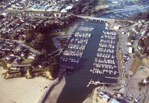
After over fifty years of relative peace and quiet on Woods Lagoon, things changed rapidly. In 1964, the U.S. Army Corps of Engineers dredged out the section of Woods Lagoon between the lagoon mouth and the railroad bridge in order to create the Santa Cruz Small Craft Harbor. Until this time, Santa Cruz did not have a proper harbor protected from the elements, and commercial use of the Santa Cruz Municipal Wharf, built in 1914, had declined to almost nothing. With the new harbor, residents would be able to safely protect their yachts, sailboats, and motorboats from the elements. In the process of creating the harbor, East Cliff Drive was bisected. To correct for this, a new vehicular bridge was extended from the end of Murray Street, which had previously ended at Seabright Avenue, to Eaton Street.

Santa Cruz Small Craft Harbor with the Glen E. Coolidge Memorial Bridge and railroad bridge at upper-center, 1973. [Santa Cruz Public Libraries]

Plans to replace the railroad bridge began in July 1968. The trestle viaduct blocked access to Woods Lagoon beyond the railroad grade. Plans for a new bridge were finalized in December 1969 and work began the next year. To maintain continuous rail service, the railroad bridge was built between the viaduct and the Murray Street bridge. Rather than a trestle, which would not allow boats to pass under it, the new design called for a concrete girder closed ballast deck bridge suspended above the lagoon via six concrete piers and two concrete abutments. The bridge reached a height of 31.88 feet above the mean tide line. To achieve this extra height, the bridge had to begin further back along the railroad grade, extending the final length of the bridge to 425 feet. Once the new bridge was completed, the old viaduct was completely dismantled. The expansion of the upper harbor began in 1972 and was completed the following year, adding 560 more berths for boats.

The bridge over the Santa Cruz Small Craft Harbor, 2017. [Derek Whaley]

The 1971 railroad bridge remains in place today and is one of the more recent bridges along the Santa Cruz Branch Rail Line. However, due to the closure of parts of the line further to the east, the bridge is only currently used for maintenance-of-way vehicles.

Geo-Coordinates & Access Rights:
Western abutment: 36.9681, -122.0036
Eastern abutment: 36.9681, -122.0022

The Woods Lagoon bridge is one of the easiest railroad bridges to view since it runs directly to the north of the Glen E. Coolidge Memorial (Murray Street) Bridge over the Santa Cruz Small Craft Harbor. It can also be viewed from below by parking at the northern end of the Mariner Park Way parking lot off Atlantic Avenue and taking the road under the bridge alongside the harbor. Another road beneath the railroad bridge is accessible off Murray Street on the east side of the harbor. As with the entire Santa Cruz Branch Rail Line, the railroad right-of-way is owned by the Santa Cruz County Regional Transportation Commission and any walking along the tracks without permission is trespassing.

Citations & Credits:

  • Clark, Donald. Santa Cruz County Place Names: A Geographical Dictionary, second edition. Santa Cruz, CA: Otter B Books, 2002.
  • Santa Cruz County GIS maps.
  • Santa Cruz Sentinel. Various articles 1874–1973.

Thursday, September 8, 2022

Curiosities: Travel Times and Speeds

Railroads do not operate in a vacuum—they run according to schedules. For large-scale railroad companies such as Southern Pacific, these are extraordinarily complex schedules that must take into account hundreds of its own trains as well as the schedules of other railroad companies and various bus systems. Thus, it should be unsurprising that railroad timetables, both public and internal-use, are invaluable sources of information to railroad historians. Yet, in the end, the primary purpose of any timetable is to keep a schedule. In fact, the entire standarization of time itself into zones was done for this precise purpose: to make it possible for railroads to run on time. And like all railroads, those that operated in and around the Santa Cruz Mountains ran according to these published schedules.

Men at the ticket window of the Santa Cruz Union Depot, 1911. [University of California, Santa Cruz, Digital Collections – colorized using MyHeritage]

Travel times for regularly-scheduled trains can vary greatly depending on the length of the route, the terrain, the gauge of rail, and the type of train. In the Santa Cruz Mountains, the terrain was a major factor, with many sharp curves and steep grades. Travel speeds through the forest were also often quite slow due to the risk of debris falling on the track that could potentially derail the train. As a result, Southern Pacific passenger train speeds were limited by 1940 to:

• 30 miles per hour between Vasona Junction and Los Gatos
• 20 mph between Los Gatos and Eva
• 25 mph between Eva and Santa Cruz, with a brief 15 mph section between Wright and Glenwood
• 20 mph between Santa Cruz and Davenport
• 30 mph between Santa Cruz and Watsonville Junction (Pajaro)
• 20 mph between Felton and Boulder Creek
• Between 40 and 75 mph (depending on locomotive type) between Gilroy and Watsonville Junction

In the earliest days of travel in Santa Cruz County, most trains ran as mixed, which means they carried both passenger and freight cars. On the other hand, the South Pacific Coast Railroad and the Southern Pacific Railroad both ran dedicated, regularly-scheduled passenger trains from the early 1880s. They did continue to operate mixed trains, but many of their trains were either regular or express passenger trains. Regular trains could stop at any registered station or flag-stop, as well as various recognized but unrecorded stops. These are, therefore, the slowest trains. Express trains, in contrast, usually only stop at a few locations along a line in order to achieve a faster travel time. Some express trains, such as the Del Monte Limited, Santa Cruz Limited, San Francisco Limited, and the seasonal Sun Tan Special were given names due to their popularity.

Early Santa Cruz County railroads, namely the Santa Cruz Railroad and the Santa Cruz & Felton Railroad, were narrow-gauge and rather crudely-built. This meant that they had slow travel times and often experienced delays or outright cancellations of service due to problems with the line or mechanical failures. When the railroads were operating normally, though, they were much better means of conveyance than the alternative of wagons or walking between destinations.

Santa Cruz Railroad's Santa Cruz depot on Park Street (now Chestnut Street), ca 1880. [Harold van Gorder Collection, Santa Cruz Museum of Art & History – colorized using DeOldify]

Santa Cruz Railroad and Branch

The earliest schedule that exists for a county railroad is that of the Santa Cruz Railroad, published in the Santa Cruz Sentinel on May 15, 1875. At this time, the line was only completed between Santa Cruz (Park Street Station) and Aptos on a journey that took about 50 minutes to cover 8.7 miles of track resulting in a train running at about 10.4 miles per hour. The first full timetable for the 21.5-mile-long Santa Cruz Railroad from Santa Cruz to Pajaro was released on June 10, 1876. At the time, an express train from Santa Cruz to Pajaro took 1 hour, 50 minutes, which translates to an average speed of 11.7 mph. The regular mixed train, in contrast, took 1 hour, 55 minutes, resulting in an average speed of 11.2 mph. Both of these trains were scheduled to meet with Southern Pacific passenger trains travelling along the Coast Division line between San José and Salinas. By 1879, the schedules had become drastically reduced, with the regular having a 1 hour, 45-minutes run and the express 1 hour, 25 minutes, resulting in speeds of 12.3 mph and 15.2 mph respectively.

When Southern Pacific took over in 1881, it immediately set about streamlining the system. The regular passenger train's time was reduced to 1 hour, 40 minutes run, while the express train was reduced to 1 hour, 3 minutes. On the final timetable before the line was standard-gauged in 1883, the time of the regular train was reduced further to 1 hour, 30 minutes, while that of the express increased slightly to 1 hour, 10 minutes. These meant that regular trains were running at 14.3 mph and express at 20.5 mph at the end of the narrow gauge era.

The upgrade to standard gauge tracks made trains larger but slightly safer to operate. Over time, this led to a gradual reduction in travel times across the Santa Cruz Branch. In 1890, regular trains took 1 hour, 25 minutes to travel from Pajaro to Santa Cruz, but express trains could make the distance in only 53 minutes. That resulted in speeds of between 15.2 and 24.3 mph. These were reduced further to 1 hour, 10 minutes for regular trains and 50 minutes for express trains by 1909. The speeds by this time, therefore, reached an average of 18.4 mph and 25.8 mph. These times remained the standard for the next 29 years, until regular passenger service ended along the Santa Cruz Branch.

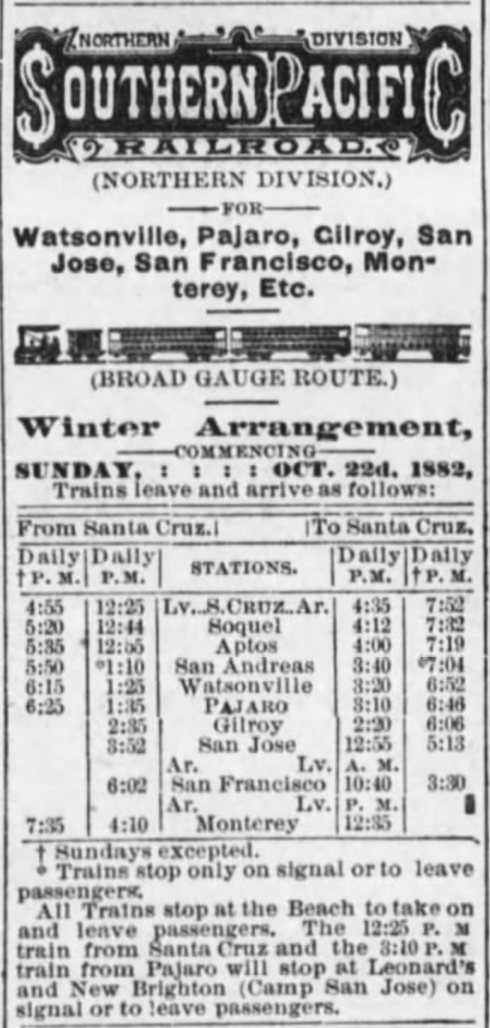
Southern Pacific Railroad schedule published in the Santa Cruz Sentinel, February 10, 1883.

San Francisco to Santa Cruz via Pajaro

The Santa Cruz Railroad was the first system in the county with the ability to connect to the Southern Pacific Railroad's Coast Division mainline at Pajaro, later Watsonville Junction. Once Southern Pacific took over and upgraded the line, a fluid exchange could happen linking Santa Cruz directly to San Francisco, although in reality there was rarely a through line between the points. Most of the time, passengers had to detrain at Pajaro and board a local train.

Passenger travel between Santa Cruz and San Francisco via the Coast Division mainline was never fast. In 1882, travel between the points—a distance of 121 miles—took around 5 hours, 10 minutes. This meant that the average speed of a journey to san Francisco was 23.4 mph. Around 1890, an express option was added that took just over 4 hours, which averaged 30.1 mph.  Over the next twenty years, the time was cut down further, eventually reaching 3 hours, 35 minutes in 1913. That brought the average speed up to 33.8 mph. From there, though, times increased again since all through traffic to San Francisco was directed north along the former South Pacific Coast route and then via the Los Altos Branch, popularly called the Mayfield Cutoff. By the end of passenger service along the Santa Cruz Branch in 1938, travel time from Santa Cruz to San Francisco via Watsonville Junction was 4 hours, 11 minutes, averaging a speed of 28.9 mph. Sun Tan Specials running from 1940 used this line to bring people to the Santa Cruz Beach and its travel time was 3 hours, 30 minutes, essentially the same as the regular passenger trains of the early 1910s.

Santa Cruz & Felton Railroad Time Table No. 2, from the Sentinel, February 10, 1877.

Santa Cruz & Felton Railroad

In some ways, the Santa Cruz & Felton Railroad was the shortest-lived of all the railroads in the county since it was wholly absorbed into the South Pacific Coast Railroad's mainline system in May 1880. It also did not formally engage in passenger service until several months after it began freight service in late 1875. But during the four years that it operated as a passenger railroad, it had a set scheduled that appeared in the local newspapers. Its No. 2 timetable, published in February 1877, gave travel time between Santa Cruz—then located at the Railroad Wharf—and Felton—near the Mountain Community Resources—as 1 hour exactly. This means that the 7-mile-long route transported passengers at a speed of...7 miles per hour. The Santa Cruz & Felton Railroad offered three runs in each direction. Later in the year, this was reduced to two runs, and in mid-1878 only one run each direction. This remained the status until the South Pacific Coast took over.

Cover of South Pacific Coast Railroad time table no. 3, March 28, 1886.

South Pacific Coast Railroad and Railway

The opening of the South Pacific Coast Railroad to Santa Cruz in 1880 heralded the first (nearly) seamless direct service between San Francisco and Santa Cruz. Nearly because a ferry was still required to transfer passengers from San Francisco to the Alameda Mole near Oakland. The South Pacific Coast was a narrow-gauge railroad that ran directly through the Santa Cruz Mountains, passing through Fremont, San José, Los Gatos, and eight tunnels before reaching the seaside town. Little changed along the line even after Southern Pacific acquired it in 1887, by which point it had reincorporated as the South Pacific Coast Railway. The entire line was not standard-gauged until spring 1909, after which most Santa Cruz–San Francisco traffic went via the Mayfield Cutoff rather than by the original Alameda route.

In the nearly thirty years from 1880, travel times between Alameda Junction and Santa Cruz remained remarkably stable. The speed of the train was always fastest between Alameda and Los Gatos, after which trains encountered a meandering track of steeper grades and sharper curves. Nonetheless, the route as a whole made good time. The April 4, 1881 timetable gave the travel time as 3 hours, 37 minutes, which resulted in an average speed of 20.8 miles per hour across 75.3 miles of trackage. Two years later, the time was reduced to 3 hours, 19 minutes leading to an uptick in the average speed to 23 mph. The timetables soon stabilized for the next decade at the slightly faster time 3 hours, 22 minutes, with trains travelling at an average speed of 22.4 mph. Perhaps due to safety concerns or constant repairs along the line, Southern Pacific eventually moved the time up around 1894 to 3 hours, 30 minutes, averaging 21.5 mph, which it retained until the 1906 San Francisco Earthquake shut down the line and it was standard-gauged.

Passengers boarding a South Pacific Coast Railway train at Ben Lomond, ca 1907. [UCSC Digital Collections – colorized using DeOldify]

Felton & Pescadero Railroad and Boulder Creek Branch

Travel time on the 7.30-mile-long Felton & Pescadero Railroad, a subsidiary of the South Pacific Coast Railroad, varied depending on which direction the train was travelling between Felton and Boulder Creek. If the train was heading north, it took 45 minutes to reach Boulder Creek. If it was heading south, possibly because trains needed to use their brakes more, it took 50 minutes to reach Felton. This meant that trains were travelling 9.7 and 8.8 miles per hour respectively. When Southern Pacific took over the line in 1887, it managed to cut the average travel time down to 33 minutes, which more or less remained standard for the next twenty years. Trains, therefore, could transport passengers between the two termini at a speed of 13.3 mph.

In 1908, when the line shifted to standard gauge, trains were finally able to run at a faster clip. For the first year, trains transported passengers between Felton and Boulder Creek in only 22 minutes! This meant the trains were running at an average speed of 19.9 mph. Clearly this was deemed unsafe, or perhaps the company changed to less efficient locomotives, since in 1909 the time was moved back to 30 minutes. Over two decades, the speed bounced between 25 and 30 minutes for the remainder of its time as a passenger line, which ceased around May 1931. Taking an average travel time of 27.5 minutes, the trains during the final years of the Boulder Creek Branch ran at a speed of 15.9 mph.

Ocean Shore Railway timetable no. 19, July 16, 1911.

Davenport-bound Railroads

Two railroads traversed the northern marine terraces of Santa Cruz County: the Ocean Shore Railway, later Railroad, and the Coast Line Railroad, a subsidiary of Southern Pacific. Both standard-gauge railroads were built at about the same time—between 1905 and 1907—and both had the stated, though unrealized, goal of linking Santa Cruz to San Francisco via a coastal route. The Ocean Shore did make it as far north as Swanton, 15.5 miles from Santa Cruz, but the most important destination along the line was Davenport, at least in the earlier years. This location was 10.8 miles from Santa Cruz on the Ocean Shore Railway, and 11.4 miles on the Coast Line Railroad.

The Ocean Shore's short, fourteen-year existence running passengers along the coast was a relatively consistent affair. All of the company's regular trains were mixed and trains took 28 minutes to run between Santa Cruz and Davenport. This resulted in an average speed of 23.1 miles per hour. The Coast Line, in contrast, began running incredibly slow trains. Initially, mixed trains took up to 1 hour, 15 minutes to transport passengers from Santa Cruz to Davenport, probably due to the number of freight stops trains along the way. So much time resulted in a dismal 9.1 mph speed. This soon picked up, though, and Southern Pacific managed to cut the time to 1 hour in late 1909, allowing trains to run at 11.4 miles per hour. By 1913, enough passenger traffic had picked up that dedicated passenger trains could operate, and these only took 30 minutes, matching the Ocean Shore's travel time and running at a far more comfortable speed of 22.8 mph. Both railroads retained this time for passenger trains until each ceased regular passenger service, in 1920 for the Ocean Shore, and in 1932 for Southern Pacific.

Southern Pacific's morning Santa Cruz express train arriving at San Francisco, August 19, 1937. Photo by Wilbur C. Whittaker [Jim Vail – colorized using DeOldify]

The Mayfield Route

The most efficient service that ever ran between Santa Cruz and San Francisco was the direct trains that Southern Pacific ran along the Los Altos Branch, commonly called the Mayfield Cutoff. What it "cut off" was San José, saving trains a major bottleneck of a station and saving several miles of track miles travelled. The Los Altos Branch, between Vasona Junction and Mayfield near Palo Alto, opened in 1908 and allowed through service from Santa Cruz beginning in mid-1909. The route proved so efficient that the mile markers along the Santa Cruz Branch were actually reversed so that they oriented north through the mountains rather than south toward Pajaro. By 1909, the latter route had been reduced to 120.5 miles between San Francisco and Santa Cruz, while the new Mayfield route was a trifling 79.2 miles.

In the early years of the Mayfield route, trains running between the two termini took 3 hours, 20 minutes to reach their destination. That meant they ran at an impressive average speed of 23.8 miles per hour. As with the South Pacific Coast Railway before it, the speed would have been considerably faster north of Los Gatos and slower through the mountains. In the early 1920s, Southern Pacific managed to shave off nearly half an hour from travel, reducing the time to 2 hours, 52 minutes, resulting in trains running at 27.6 mph. Over the subsequent twenty years, this time only got faster. By February 1940, just prior to the sudden shutdown of the route, regular trains travelling on the Mayfield route could reach San Francisco from Santa Cruz in only 3 hours, 9 minutes at a speed of 26.0 mph. But more incredible was the travel time of express trains, which could make the morning commute in 2 hours, 38 minutes at the then-incredible speed of 30.1 mph.

This was the end of regular or express commuter service in the Santa Cruz Mountains. Except for the occasional excursion train and the seasonal Sun Tan Specials, locals who wished to travel anywhere by train first had to drive or take a bus to Watsonville Junction, Los Gatos, or San José. An era of efficient, comparatively rapid transport had ended.

Citations & Credits:

  • Nanney, Duncan. Personal correspondence.
  • Santa Cruz Sentinel. Various articles, 1875-1940.
  • Southern Pacific Railroad Company, various records. California State Railroad Museum.